
Nyboder is a historic row house district of former Naval barracks in Copenhagen, Denmark. It was planned and first built by Christian IV to accommodate a need for housing for the personnel of the rapidly growing Royal Danish Navy and their families during that time. While the area is still commonly associated with the name of its founder as one of his numerous building projects around Copenhagen, the Nyboder seen today was in fact, except for a single row of houses in Sankt Pauls Gade, built from 1757.

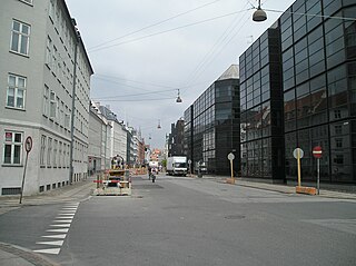
Borgergade is a street in central Copenhagen, Denmark. It runs from Gothersgade to Store Kongensgade. As one of relatively few streets in central Copenhagen, the street, in its western part, is dominated by modern buildings. The eastern part passes through the Nyboder district.

Dronningens Tværgade is a street in central Copenhagen, Denmark, which runs from Bredgade to Rosenborg Castle Garden. The street originally formed a link between the King's Garden and the Queen's Garden. With the Odd Fellows Mansion on Bredgade and the central pavilions of the east fringe of the castle garden located at each their end, the street has axial qualities. These are accentuated by the Dronningegården Estate, a Functionalist housing complex from the 1940s, which forms an urban space around the intersection with Adelgade.

Sølvgade Barracks is a former military facility from 1771 located on the corner of Sølvgade and Øster Voldgade in central Copenhagen, Denmark. The barracks closed in 1926 and the large Baroque complex designed by Nicolas-Henri Jardin then served as headquarters for DSB, the Danish state railways, until 2013, when the building was converted into student apartments.

Grønningen is a street in central Copenhagen, Denmark, connecting Bredgade and the intersecting street Esplanaden to Oslo Plads in front of Østerport Station along the southwestern margin of the fortification Kastellet. It lends its name to the artists' cooperative Grønningen which was originally based in the street.

Bygningskulturens Hus, the former Søetatens Pigeskole, is a listed Historicist building now serving as a centre for historic architecture and cultural heritage in Copenhagen, Denmark. It is located in Borgergade, next to Nyboder.

Søkvæsthuset is a former Naval hospice located on Christianshavn Canal in the Christianshavn district of Copenhagen, Denmark. The listed building housed the Royal Danish Naval Museum indtil 2016. The collection has been moved to and is exhibited at the Arsenal Museum (Tøjhusmuseet) at Christiansborg.

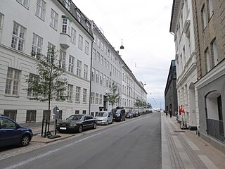
Sølvgade is a street in central Copenhagen, Denmark, extending north-west from Borgergade to The Lakes where Fredens Bro connects it to Fredensgade. The section from Kronprinsessegade to Øster Voldgade follows the walled north-eastern margin of Rosenborg Castle Garden and the next section, from Øster Voldgade to the intersection with Farimagsgade, named Sølvtorvet although it is little more than a busy street junction, separates Copenhagen Botanical Garden from Østre Anlæg.

Store Kongensgade is the longest street in central Copenhagen, Denmark. It extends northeast from Kongens Nytorv to Esplanaden, running parallel to Bredgade, where it breaks left, continuing northwest to Grønningen.

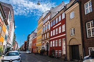
Adelgade is a street in central Copenhagen, Denmark. It runs from Gothersgade in the south to Sankt Pauls Plads with St. Paul's Church in the north. The first half of the street is dominated by modern buildings while its last section passes through the Nyboder district.
Wildersgade is a street in the Christianshavn district of Copenhagen, Denmark. It runs along the length of the neighbourhood, parallel to Christianshavn Canal, one block to the east, from the Christiansbro development in the south(west) to Wilder's Canal in the north(east). The street is bisected by Torvegade, Christianshavn's principal thoroughfare, but is otherwise a quiet mainly residential street with cobbling and many old townhouses and storages from the 18th and 19th century.
Bremerholm is a street in central Copenhagen, Denmark. It extends south from the major shopping street Strøget to Holmens Kanal. Together with Kristen Bernikows Gade, its extension to the north, it forms one of only two places where car traffic crosses pedestrianized Strøget on its way from Kongens Nytorv to the City Hall Square, the other being at Gammeltorv-Nytorv. The small square Magasins Torv is located in front of one of the entrances to the department store Magasin du Nord at the beginning of the street

Rigensgade is a street in central Copenhagen, Denmark. It links Sølvgade in the west with Øster Voldgade in the east. An underpass for pedestrians link the beginning of the street with Rosenborg Castle Gardens on the other side of Sølvgade. Notable buildings include the former Garrison Hospital. and the Methodist Jerusalem's Church.

Antonigade is a street in the Old Town of Copenhagen, Denmark. It runs from Pilestræde in the southwest to Kristen Bernikows Gade in the northeast. No. 3 and No. 9 are listed on the Danish registry of protected buildings and places.
Fredericiagade is a street in central Copenhagen, Denmark. It runs from Amaliegade in the south to Rigensgade in the north.
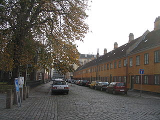
Sankt Pauls Gade is a street in the Nyboder Quarters of central Copenhagen, Denmark. The street passes St. Paul's Church from which it takes its name. The space in front of the church is called Sankt Pauls Plads.

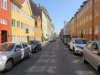
Gernersgade is a street in the Nyboder Quarter of central Copenhagen, Denmark. It runs from Store Kongensgade in the southeast to Rigensgade in the northwest and is closed to through traffic at Sankt Pauls Plads.

Silkegade is a minor street in the Old Town of Copenhagen, Denmark, linking busy shopping street Købmagergade in the west with Pilestræde in the east. Sparekassen Bikuben's former headquarters at No. 6–8 is listed on the Danish registry of protected buildings and places. The entrance to department store Illum's multi-storey parking facility is also located in the street.
Kvæsthusgade is a short street in the Nyhavn Quarter of central Copenhagen, Denmark. It runs from the mouth of the Nyhavn canal in the south to Ofelia Plads in the north. The rear side of the Royal Danish Playhouse dominates the east side of the street.

Store Kongensgade 77 is a property on Store Kongensgade, opposite Frederik's Church, in central Copenhagen, Denmark. It was listed in the Danish registry of protected buildings and places in 1964.


