
South Africa occupies the southern tip of Africa, its coastline stretching more than 2,850 kilometres from the desert border with Namibia on the Atlantic (western) coast southwards around the tip of Africa and then northeast to the border with Mozambique on the Indian (eastern) coast. The low-lying coastal zone is narrow for much of that distance, soon giving way to a mountainous escarpment that separates the coast from the high inland plateau. In some places, notably the province of KwaZulu-Natal in the east, a greater distance separates the coast from the escarpment. Although much of the country is classified as semi-arid, it has considerable variation in climate as well as topography. The total land area is 1,220,813 km2 (471,359 sq mi). It has the 23rd largest Exclusive Economic Zone of 1,535,538 km2 (592,875 sq mi).

Fynbos is a small belt of natural shrubland or heathland vegetation located in the Western Cape and Eastern Cape provinces of South Africa. This area is predominantly coastal and mountainous, with a Mediterranean climate and rainy winters. The fynbos ecoregion is within the Mediterranean forests, woodlands, and scrub biome. In fields related to biogeography, fynbos is known for its exceptional degree of biodiversity and endemism, consisting of about 80% species of the Cape floral kingdom, where nearly 6,000 of them are endemic. This land continues to face severe human-caused threats, but due to the many economic uses of the fynbos, conservation efforts are being made to help restore it.

The Karoo is a semi-desert natural region of South Africa. No exact definition of what constitutes the Karoo is available, so its extent is also not precisely defined. The Karoo is partly defined by its topography, geology and climate, and above all, its low rainfall, arid air, cloudless skies, and extremes of heat and cold. The Karoo also hosted a well-preserved ecosystem hundreds of million years ago which is now represented by many fossils.
The Olifants River is a river in the northwestern area of the Western Cape Province of South Africa. The upper and main catchment area of the Olifants river is around Ceres and the Cederberg mountains. The Clanwilliam and Bulshoek dams are located on the river and provide water for the towns and farms along the watercourse. The river is approximately 285 km long with a catchment area of 46,220 km2. It flows into the Atlantic Ocean at Papendorp, 250 km north of Cape Town.

The Swartberg mountains are a mountain range in the Western Cape province of South Africa. It is composed of two main mountain chains running roughly east–west along the northern edge of the semi-arid Little Karoo. To the north of the range lies the other large semi-arid area in South Africa, the Great Karoo. Most of the Swartberg Mountains are above 2000 m high, making them the tallest mountains in the Western Cape. It is also one of the longest, spanning some 230 km from south of Laingsburg in the west to between Willowmore and Uniondale in the east. Geologically, these mountains are part of the Cape Fold Belt.

The R62 is a provincial route in South Africa that connects Ashton with Humansdorp. The R62 runs through the Little Karoo and the Langkloof, passing through Montagu, Ladismith, Calitzdorp, Oudtshoorn, and Joubertina.

The Ponmudi Dam is a concrete gravity dam built across the Panniyar river which is a tributary of Periyar river at Konnathady panchayath of Konnathadi village in Idukki district of Kerala, India. The dam was constructed in 1963 as a part of a hydroelectric project. Construction was led by E.U.Philipose, Superintending Engineer, Kerala State Electricity Board. It has a length of 288.80 metres (947.5 ft). The hydropower component of the dam has an installed capacity of 30 MW with firm power of 17 MW, generating 158 GWh annually. Taluks through which the river flow are Udumbanchola, Devikulam, Kothamangalam, Muvattupuzha, Kunnathunadu, Aluva, Kodungalloor and Paravur.
The Enon Formation is a geological formation found in the Eastern and Western Cape provinces in South Africa. It is the lowermost of the four formations found within the Uitenhage Group of the Algoa Basin, its type locality, where it has been measured at a maximum thickness of 480 metres (1,570 ft). Discontinuous outcrops are also found in the Worcester-Pletmos and Oudshoorn-Gamtoos Basins, including isolated occurrences in the Haasvlakte, Jubilee, and Soutpansvlakte Basins near the small town Bredasdorp.
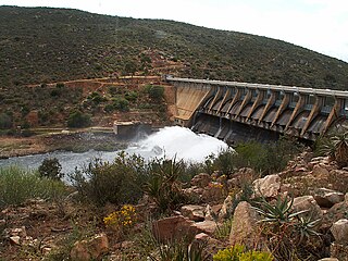
Clanwilliam Dam is a concrete gravity dam on the Olifants River, near Clanwilliam, Western Cape, South Africa. It was established in 1935, and the wall was raised to its current height of 43 metres (141 ft) in 1964. The main purpose of the dam is to provide irrigation water to the agricultural region downstream. It has a water storage capacity of 121,800,000 cubic metres (4.30×10⁹ cu ft).

Wemmershoek Dam is a rock-fill type dam located on the Wemmershoek River near Franschhoek and Paarl in South Africa. It was constructed between 1953 and 1957 on behalf of the City of Cape Town. With a reservoir capacity of 58,644 megalitres, it provides approximately 6.5% of the storage capacity of the Western Cape Water Supply System which supplies Cape Town and surrounding areas.
Gamka River is a river located in the Western Cape, South Africa. The name 'gamka' means 'Lion' and was probably named so by the San people (Bushmen). The river originates north of Beaufort West, generally flowing southwest towards the Gamkapoort Dam.

Gourits River, sometimes spelled 'Gouritz River', is situated in the Western Cape, South Africa.
The Tarka River is a river in the Eastern Cape, South Africa. Along with the Baviaans River, Grootbrak River and Kat River it is a major eastern tributary of the Great Fish River. The Lake Arthur Dam and the Kommandodrif Dam are located in this river. The latter is included in the Commando Drift Nature Reserve.
The Touws River is a river in the Western Cape province of South Africa. It is a tributary of the Groot River, part of the Gourits River basin. A notable resident of the town is Margaret Maritz who, as of 2022, aged 116, was regarded as one of the oldest people in South Africa.
Dysselsdorp is a small town that lies between Oudtshoorn and De Rust in the Little Karoo. It was founded as missionary station in 1838 for the emancipated slaves and dispossessed Khoekhoen who lived in the area. Since 1996 Dysselsdorp has been used as a case study for multiple agricultural reform programmes. 12 544 People live in Dysselsdorp and it is a predominantly Afrikaans-speaking coloured community. Majority of Dysselsdorp’s workers are employed in the agricultural industry or work in the nearby town of Oudtshoorn. Dysselsdorp is located in two wards of the Oudtshoorn Local Municipality.

The Groot River is a river in the southern area of the Western Cape province of South Africa. It is a right hand tributary of the Gourits River.

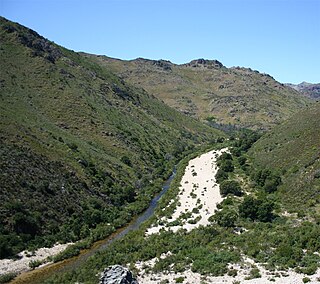
Buffelspoort is the westernmost of five defiles that cut through the Swartberg Mountain range, situated in the Western Cape province of South Africa. The others are the Seweweekspoort, Die Poort, where the Gamka River transects Die Hel, Meiringspoort, and Snykloof at its eastern extremity.
The Kammanassie Mountains are a mountain range in the Western Cape, South Africa. The highest peak is Mannetjiesberg at 1,955 metres above sea level and the mountain range is one of the prominent east-west trending ranges composing the southern branch of the Cape Fold Belt.
The Klein Berg River is a major right-hand tributary of the Berg River in the Western Cape province of South Africa. The Klein Berg drains the Tulbagh basin through the Nuwekloof into the Swartland, where it joins the Berg.
The 1981 Laingsburg Flood was a catastrophic event that occurred on 25 January 1981 in the town of Laingsburg, Western Cape, South Africa. The flood killed at least 104 residents, and the bodies of 72 people were never found. A total of 184 houses were destroyed.
