Oliphants Drift

Last updated

Oliphants Drift is a village in Kgatleng District of Botswana. It is located 85 km north-east of Mochudi, close to the border with South Africa. The village has a primary school and a health clinic, and the population was 758 in 2001 census. [1]

Kgatleng District District in Botswana

Kgatleng is one of the districts of Botswana, coterminous with the homeland of the Bakgatla people. Its capital is Mochudi, the hometown of protagonist Precious Ramotswe in Alexander McCall Smith's popular The No. 1 Ladies' Detective Agency series. According to the 2001 Census, Kgatleng had a population of 73,507 people.

Botswana republic in southern Africa

Botswana, officially the Republic of Botswana, is a landlocked country in Southern Africa. Formerly the British protectorate of Bechuanaland, Botswana adopted its new name after becoming independent within the Commonwealth on 30 September 1966. Since then, it has been a representative republic, with a consistent record of uninterrupted democratic elections and the best perceived corruption ranking in Africa since at least 1998. It is currently Africa's oldest continuous democracy.

Mochudi Village in Kgatleng District, Botswana

Mochudi is one of the larger villages in Botswana with a population of 44,815 people in 2011. It is situated in the Bakgatla tribal region, in Kgatleng District, about 37 km (23 mi) northeast of Gaborone. The village lies several kilometres from the main Gaborone–Francistown road, and can be accessed through a short turn at Pilane. Mochudi was settled by the Tswana people in 1871.

Related Research Articles

Riverton, Illinois Village in Illinois, United States

Riverton is a village in Sangamon County, Illinois, United States. The population was 3,455 at the 2010 census, up from 3,062 in 2000. It is part of the Springfield, Illinois Metropolitan Statistical Area.

Urbana, New York Town in New York, United States

Urbana is a town in Steuben County, New York, United States. The population was 2,546 at the 2000 census.

Newtonsville, Ohio Village in Ohio, United States

Newtonsville is a village in Clermont County, Ohio, United States. The population was 392 at the 2010 census.

Beallsville, Ohio Village in Ohio, United States

Beallsville is a village in Monroe County, Ohio, United States. As of the 2010 census, the village population was 409.

Novigrad, Zadar County Municipality in Zadar, Croatia

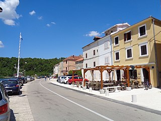
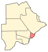
Novigrad is a village and municipality in Croatia in the Zadar County. According to the 2011 census, there are 2,375 inhabitants, absolute majority which are Croats.

Bystre, Lower Silesian Voivodeship Village in Lower Silesian, Poland

Bystre is a village in the administrative district of Gmina Oleśnica, within Oleśnica County, Lower Silesian Voivodeship, in south-western Poland. Prior to 1945 it was in Germany.

Artashar Place in Armavir, Armenia

Artashar, is a village in the Armavir Province of Armenia. Almost 42% of the population are from the Yazidi minority.

Dzyunashogh Place in Lori Province, Armenia

Dzyunashogh is a town in the Lori Province of Armenia. Until 1989 it was known as Kizil Shafaq and predominantly populated by ethnic Azerbaijanis. Between May and July 1989 the Azerbaijani population of Kizil Shafaq effected an unusual village exchange with the then-Armenian population of Kerkenj in Azerbaijan.

Lusashogh Place in Ararat, Armenia

Lusashogh is a village in the Ararat Province of Armenia.

Świeciechów Poduchowny Village in Lublin, Poland

Świeciechów Poduchowny is a village in the administrative district of Gmina Annopol, within Kraśnik County, Lublin Voivodeship, in eastern Poland. It lies approximately 6 kilometres (4 mi) north of Annopol, 26 km (16 mi) west of Kraśnik, and 62 km (39 mi) south-west of the regional capital Lublin.

Pomyków, Świętokrzyskie Voivodeship Village in Świętokrzyskie, Poland

Pomyków is a village in the administrative district of Gmina Końskie, within Końskie County, Świętokrzyskie Voivodeship, in south-central Poland. It lies approximately 3 kilometres (2 mi) south-east of Końskie and 36 km (22 mi) north of the regional capital Kielce.

Lockington, Leicestershire village in United Kingdom

Lockington is a village in the Leicestershire parish of Lockington-Hemington. The village is close to the Derbyshire border. The population at the 2011 census was included in the civil parish of Lockington-Hemington.

Rokci (Aleksandrovac) Village in Šumadija, Serbia

Rokci is a village in the municipality of Aleksandrovac, Serbia. According to the 2002 census, the village has a population of 213 people.

Balčak Village in Toplica District, Serbia

Balčak is a village in the municipality of Prokuplje, Serbia. According to the 2002 census, the village has a population of 26 people.

Lipenovići Village in Republika Srpska, Bosnia and Herzegovina

Lipenovići is a village in the municipality of Bratunac, Bosnia and Herzegovina.

Kõivuküla is a village in Kastre Parish, Tartu County in eastern Estonia.

Zalužje, Nevesinje Village in Republika Srpska, Bosnia and Herzegovina

Zalužje is a village in the municipality of Nevesinje, Republika Srpska, Bosnia and Herzegovina.

Dzahadjou is a village on the island of Grande Comore (Ngazidja) in the Comoros. According to the 1991 census, the village had a population of 1319.

Vinjište Village in Šumadija District, Serbia

Vinjište is a village in the municipality of Stanovo, Serbia. According to the 2002 census, the village has a population of 412 people.

Cetnica Village in Gradačac, Bosnia and Herzegovina

Cetnica is a village in the municipality of Gradačac, Bosnia and Herzegovina.

References

Coordinates: 24°10′52″S26°50′54″E / 24.18111°S 26.84833°E / -24.18111; 26.84833

Geographic coordinate system Coordinate system

A geographic coordinate system is a coordinate system that enables every location on Earth to be specified by a set of numbers, letters or symbols. The coordinates are often chosen such that one of the numbers represents a vertical position and two or three of the numbers represent a horizontal position; alternatively, a geographic position may be expressed in a combined three-dimensional Cartesian vector. A common choice of coordinates is latitude, longitude and elevation. To specify a location on a plane requires a map projection.