Allamakee County is the northeastern-most county in the U.S. state of Iowa. As of the 2010 census, the population was 14,330. Its county seat is Waukon.

Hopkins Park is a village in Kankakee County, Illinois, United States. The population was 603 at the 2010 census, down from 711 at the 2000 census. It is part of the Kankakee–Bradley Metropolitan Statistical Area.

White City is a village in Macoupin County, Illinois, United States. The population was 221 at the 2000 census.

Ulysses is a village in Butler County, Nebraska, United States. The population was 171 at the 2010 census.
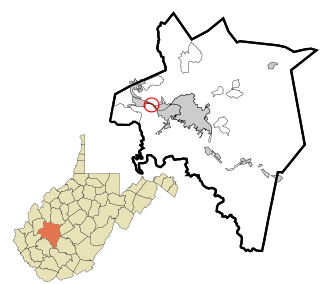
Jefferson is a census-designated place (CDP) in Kanawha County, West Virginia, United States, along the Kanawha River. The population was 676 at the 2010 census. Jefferson was incorporated on March 22, 1997, but was disincorporated less than a decade later on February 21, 2007.

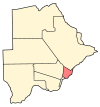
Nata is a village in Central District of Botswana. It is located in the northern part of the district, and is served by Nata Airport. The population was 4,150 at the 2001 census. The village of Nata lies along the Nata River, which carries its rainy season flow to the Makgadikgadi Pans, a seasonal hypersaline lake.
Kgomodiatshaba is a village in Kgatleng District of Botswana. The village is located around 110 km north of Mochudi, and it has a primary school. The population was 330 in 2001 census.

Arayi ; formerly known as Bazarjik and Ara, is a village in the Aragatsotn Province of Armenia. It is home to a ruined caravanserai dating back to 1213.
Norashen ; known as Sachlu until 1946, is a village in the western part of the Aragatsotn Province of Armenia.

Kotuszów is a village in the administrative district of Gmina Szydłów, within Staszów County, Świętokrzyskie Voivodeship, in south-central Poland. It lies approximately 6 kilometres (4 mi) east of Szydłów, 9 km (6 mi) north-west of Staszów, and 45 km (28 mi) south-east of the regional capital Kielce.
Pogorzele is a village in the administrative district of Gmina Ślesin, within Konin County, Greater Poland Voivodeship, in west-central Poland. It lies approximately 8 kilometres (5 mi) east of Ślesin, 21 km (13 mi) north-east of Konin, and 102 km (63 mi) east of the regional capital Poznań.
Wierzelin is a village in the administrative district of Gmina Ślesin, within Konin County, Greater Poland Voivodeship, in west-central Poland. It lies approximately 9 kilometres (6 mi) east of Ślesin, 21 km (13 mi) north-east of Konin, and 103 km (64 mi) east of the regional capital Poznań.
Kłączno is a village in Gmina Studzienice, Bytów County, Pomeranian Voivodeship, in northern Poland. It lies approximately 11 kilometres (7 mi) south-east of Bytów and 78 km (48 mi) south-west of Gdańsk.
Bukowo Człuchowskie is a village in the administrative district of Gmina Człuchów, within Człuchów County, Pomeranian Voivodeship, in northern Poland. It lies approximately 9 kilometres (6 mi) south of Człuchów and 121 km (75 mi) south-west of the regional capital Gdańsk.
Pobłocie is a village in the administrative district of Gmina Linia, within Wejherowo County, Pomeranian Voivodeship, in northern Poland.
Wilkasy is a village in the administrative district of Gmina Gołdap, within Gołdap County, Warmian-Masurian Voivodeship, in northern Poland, close to the border with the Kaliningrad Oblast of Russia.

Vrnčani is a village in the municipality of Gornji Milanovac, Serbia. According to the 2011 census, the village has a population of 330 people.
Borajno is a village in the municipality of Čajniče, Bosnia and Herzegovina.
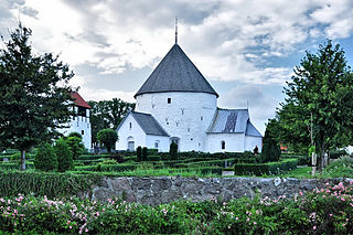
Nylars is a village in the southwest of the Danish island of Bornholm, 8 km west of Rønne and 8 km east of Aakirkeby. In January 2015 it had a population of 216. It is best known for Nylars Church, the island's second largest round church. The village developed at the beginning of the 20th century as a result of the railway line from Rønne to Nexø. It is located between the railway to the north and the main road from Rønne to Aarkirkeby to the south.
Daukšiagirė Manor is a former residential manor in Daukšiagirė village, Prienai District Municipality, Lithuania.