New Holland is a village in Logan County, Illinois, United States. The population was 269 at the 2010 census, down from 318 in 2000.

Junction City is a village in Marion County, Illinois, United States. The population was 559 at the 2000 census.

Raymond is a city in Black Hawk County, Iowa, United States. The population was 788 at the 2010 census. It is part of the Waterloo–Cedar Falls Metropolitan Statistical Area.

Gann, also known as Brinkhaven, is a village in Knox County, Ohio, United States. The population was 125 at the 2010 census.
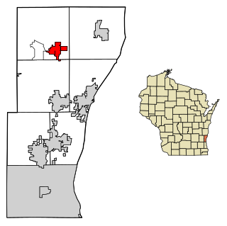
Friendship is a town in Fond du Lac County, Wisconsin, United States. The population was 2,406 at the 2000 census. The unincorporated communities of Dexter and Van Dyne are located within the town.

Carlisle is a village in northwestern Warren and southern Montgomery counties in the southwestern part of the U.S. state of Ohio. As of the 2010 census, the village's population was 4,915, down from 5,121 in the 2000 census. This population loss caused Carlisle to once again become a village. The village is in Franklin Township, Warren County, Ohio and German Township, Montgomery County, Ohio.
Fredonia is a village in Ozaukee County, Wisconsin, United States. The population was 2,160 at the 2010 census.

Polkovnik Zhelyazovo is a village in Krumovgrad municipality, Kardzhali Province, located in the Eastern Rhodope Mountains of southern Bulgaria.
Jiyyammavalasa is a village in Vizianagaram district of the Indian state of Andhra Pradesh.

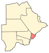
Nata is a village in Central District of Botswana. It is located in the northern part of the district, and is served by Nata Airport. The population was 4,150 at the 2001 census. The village of Nata lies along the Nata River, which carries its rainy season flow to the Makgadikgadi Pans, a seasonal hypersaline lake.

Nor Geghi is a major village in the Kotayk Province of Armenia, located around 22 km north of the capital Yerevan, near the town of Nor Hachen. As of the 2011 census, the population of the village is 5,319.

Nowa Wieś is a village in the administrative district of Gmina Długosiodło, within Wyszków County, Masovian Voivodeship, in east-central Poland. It lies approximately 8 kilometres (5 mi) west of Długosiodło, 20 km (12 mi) north of Wyszków, and 70 km (43 mi) north-east of Warsaw.
Karczówka is a village in the administrative district of Gmina Zwoleń, within Zwoleń County, Masovian Voivodeship, in east-central Poland. It lies approximately 3 kilometres (2 mi) north of Zwoleń and 101 km (63 mi) south-east of Warsaw.
Goraj is a village in the administrative district of Gmina Przytoczna, within Międzyrzecz County, Lubusz Voivodeship, in western Poland. It lies approximately 6 kilometres (4 mi) east of Przytoczna, 18 km (11 mi) north-east of Międzyrzecz, 38 km (24 mi) south-east of Gorzów Wielkopolski, and 73 km (45 mi) north of Zielona Góra.
Powalice is a village in the administrative district of Gmina Ińsko, within Stargard County, West Pomeranian Voivodeship, in north-western Poland. It lies approximately 6 kilometres (4 mi) west of Ińsko, 32 km (20 mi) east of Stargard, and 59 km (37 mi) east of the regional capital Szczecin.

Petrovac is a village in the municipality of Prokuplje, Serbia. According to the 2002 census, the village has a population of 436 people.

Gornje Pale is a village in the municipality of Pale, Bosnia and Herzegovina.
Vrba is a village in the municipality of Trebinje, Republika Srpska, Bosnia and Herzegovina.
Pribidoli is a village in the municipality of Srebrenica, Bosnia and Herzegovina.
Kumane is a village in the municipality of Veliko Gradište, Serbia. According to the 2002 census, the village has a population of 431 people.