Merakamudidam is a village in Vizianagaram district of the Indian state of Andhra Pradesh, India.

The Giardino Botanico Montano di Pratorondanino is a nature preserve and botanical garden located at 750 meters altitude in Pratorondanino, Campo Ligure, Province of Genoa, Liguria, Italy. It is open during the warmer months.
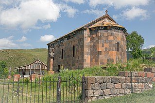
Gogaran, is a village in the Lori Province of Armenia.

Karaglukh is a town in the Vayots Dzor Province of Armenia.

Na Polach is a village in the administrative district of Gmina Tuchola, within Tuchola County, Kuyavian-Pomeranian Voivodeship, in north-central Poland. It lies approximately 4 kilometres (2 mi) east of Tuchola and 55 km (34 mi) north of Bydgoszcz.
Kawka is a village in the administrative district of Gmina Niemce, within Lublin County, Lublin Voivodeship, in eastern Poland. It lies approximately 12 kilometres (7 mi) west of Niemce and 17 km (11 mi) north-west of the regional capital Lublin.

Lələbağırlı is a village in the Lachin Rayon of Azerbaijan.
Januszowice is a village in the administrative district of Gmina Zielonki, within Kraków County, Lesser Poland Voivodeship, in southern Poland. It lies approximately 10 km (6 mi) north of the regional capital Kraków.
Wasylów is a village in the administrative district of Gmina Ulhówek, within Tomaszów Lubelski County, Lublin Voivodeship, in eastern Poland, close to the border with Ukraine. It lies approximately 9 kilometres (6 mi) east of Ulhówek, 34 km (21 mi) east of Tomaszów Lubelski, and 130 km (81 mi) south-east of the regional capital Lublin. The village is located in the historical region Galicia.
Brzostków is a village in the administrative district of Gmina Nowy Korczyn, within Busko County, Świętokrzyskie Voivodeship, in south-central Poland. It lies approximately 7 kilometres (4 mi) east of Nowy Korczyn, 22 km (14 mi) south-east of Busko-Zdrój, and 67 km (42 mi) south of the regional capital Kielce.
Chruszczyna Mała is a village in the administrative district of Gmina Kazimierza Wielka, within Kazimierza County, Świętokrzyskie Voivodeship, in south-central Poland. It lies approximately 5 kilometres (3 mi) south of Kazimierza Wielka and 73 km (45 mi) south of the regional capital Kielce.
Rudniki is a village in the administrative district of Gmina Połaniec, within Staszów County, Świętokrzyskie Voivodeship, in south-central Poland. It lies approximately 5 kilometres (3 mi) north of Połaniec, 13 km (8 mi) south-east of Staszów, and 66 km (41 mi) south-east of the regional capital Kielce.
Budzyno-Walędzięta is a village in the administrative district of Gmina Czerwonka, within Maków County, Masovian Voivodeship, in east-central Poland. It lies approximately 9 kilometres (6 mi) west of Czerwonka, 4 km (2 mi) north of Maków Mazowiecki, and 76 km (47 mi) north of Warsaw.

The Povilas Stulga Museum of Lithuanian Folk Instruments is located in the Old Town of Kaunas, Lithuania. Its permanent collection contains Lithuanian and international musical instruments, recordings, books, placards, photographs, and letters.

Tin Heng is an MTR Light Rail stop. It is at ground level of Tin Shui Road near Tin Heng Estate, in Tin Shui Wai, Yuen Long District, Hong Kong. It began service on 7 December 2003 and belongs to Zone 5A.
Kosobądź is a settlement in the administrative district of Gmina Ostrowice, within Drawsko County, West Pomeranian Voivodeship, in north-western Poland.
Hostovlice is a village and municipality in Kutná Hora District in the Central Bohemian Region of the Czech Republic.

El Ogla District is a district of Tébessa Province, Algeria.
Hilltop is a rural community in the Rural Municipality of Clanwilliam and is a mixed agricultural area.

Bandholm Church is a located in the harbor village of Bandholm some 8 km (5.0 mi) north of Maribo on the Danish island of Lolland. It was built in 1874 by Henrik Steffens Sibbern to a cruciform plan in the Romanesque Revival style. Built of red brick, it consists of a chancel, a nave and a tower with a conical spire.


