
Valkeala is a former municipality of Finland.
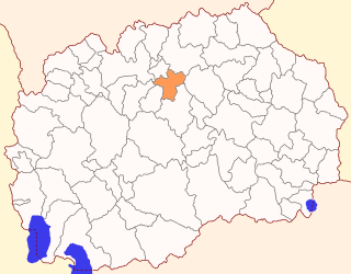
The Municipality of Petrovec is a municipality in northern Republic of North Macedonia, near the capital Skopje. Petrovec is also the name of the village where the municipal seat is found. It is located in the Skopje Statistical Region.

Renews–Cappahayden is a small fishing town on the southern shore of Newfoundland, 83 kilometres south of St. John's.

Lorut, is a village in the Lori Province of Armenia. It belongs to the municipality of Tumanyan.
Musayelyan or Musayelian; formerly known as Bozyoxush is a village in the Shirak Province of Armenia. It was named after the Bolshevik military leader Sargis Musayelyan.
Za Jeziorem is a former settlement in the administrative district of Gmina Tuchola, within Tuchola County, Kuyavian-Pomeranian Voivodeship, in north-central Poland.
Nowa Kamienna is a village in the administrative district of Gmina Dąbrowa Białostocka, within Sokółka County, Podlaskie Voivodeship, in north-eastern Poland.

Zielony Gaj is a village in the administrative district of Gmina Janów, within Sokółka County, Podlaskie Voivodeship, in north-eastern Poland. It lies approximately 7 kilometres (4 mi) north-east of Janów, 21 km (13 mi) north-west of Sokółka, and 46 km (29 mi) north of the regional capital Białystok.

Maralyansarov is a village in the Tartar Rayon of Azerbaijan.
Zagaje is a village in the administrative district of Gmina Iwanowice, within Kraków County, Lesser Poland Voivodeship, in southern Poland.
Bugaj is a village in the administrative district of Gmina Strawczyn, within Kielce County, Świętokrzyskie Voivodeship, in south-central Poland. It lies approximately 7 kilometres (4 mi) east of Strawczyn and 10 km (6 mi) north-west of the regional capital Kielce.
Potok-Kolonia is a village in the administrative district of Gmina Ożarów, within Opatów County, Świętokrzyskie Voivodeship, in south-central Poland. It lies approximately 6 kilometres (4 mi) north of Ożarów, 22 km (14 mi) north-east of Opatów, and 73 km (45 mi) east of the regional capital Kielce.
Chocimów is a village in the administrative district of Gmina Kunów, within Ostrowiec County, Świętokrzyskie Voivodeship, in south-central Poland. It lies approximately 4 kilometres (2 mi) south-west of Kunów, 11 km (7 mi) west of Ostrowiec Świętokrzyski, and 45 km (28 mi) east of the regional capital Kielce.
Trawniki is a village in the administrative district of Gmina Lubomia, within Wodzisław County, Silesian Voivodeship, in southern Poland. It lies approximately 3 kilometres (2 mi) west of Lubomia, 14 km (9 mi) west of Wodzisław Śląski, and 58 km (36 mi) south-west of the regional capital Katowice.
Podlesiec is a village in the administrative district of Gmina Dobiegniew, within Strzelce-Drezdenko County, Lubusz Voivodeship, in western Poland.

The Magech River is a river of Ethiopia. It rises just of the city of Gondar, and flows south into Lake Tana at the latitude and longitude of 12°16′10″N37°23′50″E. Its tributaries include the Dmaza, the Lesser Angereb, and the Ahyamezoriya.

Englewood is an unincorporated community in Humboldt County, California. It is located 0.5 miles (0.8 km) east-southeast of Redcrest, at an elevation of 364 feet. The area is the site of a few homes and a derelict Eel River Sawmills mill.

Kelly is a small village in west Devon, England.

Rudolfplatz is an interchange station and hub on the Cologne Stadtbahn lines 1, 7, 12 and 15 in the Cologne district of Innenstadt. The station is located at Rudolfplatz, a major junction between the Cologne Ring and Aachener Straße.

Syekh Hamzah Fansyuri Airport is an airport located in Singkil, Aceh Singkil Regency, Aceh, Indonesia.


