De Kempervennen is a Center Parcs holiday village situated in Westerhoven, North Brabant, Netherlands. Activities include the sub-tropical swimming paradise, various outdoor and indoor adventure activities, a sports hall, 'kids klub', children's farm, watersports, a "real snow" indoor ski slope, evening shows and forest surroundings.

Lower Wick is a small hamlet located in the county of Gloucestershire, England. It is situated about five miles south west of Dursley, eighteen miles southwest of Gloucester and fifteen miles northeast of Bristol. Lower Wick is within the civil parish of Alkington.
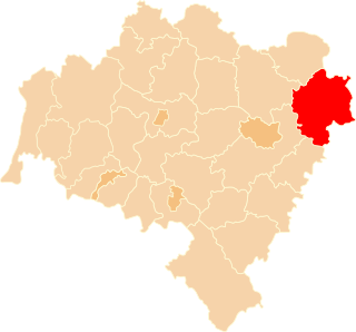
Tworzymirki Górne is a village in the administrative district of Gmina Milicz, within Milicz County, Lower Silesian Voivodeship, in south-western Poland. Prior to 1945 it was in Germany.

Heikant is a neighbourhood in the municipality of Veldhoven, in the Dutch province of North Brabant. With a population of over 6700 inhabitants, it is the largest neighbourhood in Veldhoven. Heikant contains a small shopping centre and a church. The Sint-Maartenchurch was built in 1990.

Borówki is a village in the administrative district of Gmina Sośno, within Sępólno County, Kuyavian-Pomeranian Voivodeship, in north-central Poland. It lies approximately 5 kilometres (3 mi) north-west of Sośno, 9 km (6 mi) south-east of Sępólno Krajeńskie, and 42 km (26 mi) north-west of Bydgoszcz.
Gocław is a village in the administrative district of Gmina Lubień Kujawski, within Włocławek County, Kuyavian-Pomeranian Voivodeship, in north-central Poland.
Siemiatycze-Stacja is a village in the administrative district of Gmina Siemiatycze, within Siemiatycze County, Podlaskie Voivodeship, in north-eastern Poland.
Kącik is a village in the administrative district of Gmina Drużbice, within Bełchatów County, Łódź Voivodeship, in central Poland. It lies approximately 5 kilometres (3 mi) south of Drużbice, 8 km (5 mi) north of Bełchatów, and 40 km (25 mi) south of the regional capital Łódź.

Hapıtlı is a village in the Agdash Rayon of Azerbaijan. The village forms part of the municipality of Aşağı Ləki.
Isaqlı is a village in the Jabrayil Rayon of Azerbaijan.
Ləpəhəyranlı is a village in the Qubadli Rayon of Azerbaijan.
Unuz is a village in the Astara Rayon of Azerbaijan.
Szczerków is a village in the administrative district of Gmina Zduny, within Krotoszyn County, Greater Poland Voivodeship, in west-central Poland. It lies approximately 5 kilometres (3 mi) north of Zduny, 3 km (2 mi) west of Krotoszyn, and 86 km (53 mi) south of the regional capital Poznań.
Pieczyska is a village in the administrative district of Gmina Doruchów, within Ostrzeszów County, Greater Poland Voivodeship, in west-central Poland. It lies approximately 7 kilometres (4 mi) west of Doruchów, 3 km (2 mi) north of Ostrzeszów, and 132 km (82 mi) south-east of the regional capital Poznań.
Niepoczołowice-Folwark is a village in the administrative district of Gmina Linia, within Wejherowo County, Pomeranian Voivodeship, in northern Poland. It lies approximately 5 kilometres (3 mi) south-west of Linia, 31 km (19 mi) south-west of Wejherowo, and 49 km (30 mi) west of the regional capital Gdańsk.

Modřany is a suburb of Prague south of the city centre on the banks of the Vltava. It belongs to the municipal district Prague 12. Before being joined with the capital Prague in year 1974, Modřany was de facto a town.
Koidula is a village in Saaremaa Parish, Saare County in western Estonia.

Tonbridge and Malling Borough Council (TMBC) is the second level local authority for the Borough of Tonbridge and Malling in Kent, United Kingdom.
South Woodbury is an unincorporated community in Morrow County, in the U.S. state of Ohio.
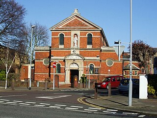
St Agatha's is a Roman Catholic Church in Kingston upon Thames, London. It is dedicated to Saint Agatha and is located at 1 Wyndham Road, Kingston upon Thames KT2 5JR.