Sandnes (help·info) is a city and municipality in Rogaland county, Norway. It is the 8th largest city in Norway and it lies immediately south of the city of Stavanger, the 4th largest city in Norway. Together, the Stavanger/Sandnes area is the 3rd largest urban area in Norway.

Time is a municipality in Rogaland county, Norway. It is located in the traditional district of Jæren. The administrative centre of the municipality is the town of Bryne. Some villages in the municipality include Kvernaland, Lyefjell, Mossige, and Undheim. Most of Time is fairly flat and it is used for agriculture. The eastern portion of the municipality is more rugged moorland.

Forsand is a municipality in Rogaland county, Norway. It is located in the traditional district of Ryfylke. The administrative centre of the municipality is the village of Forsand. Other villages in the municipality include Lysebotn, Øvre Espedal, Oanes, Kolabygda, and Fløyrli.

Ålgård is the administrative centre of Gjesdal municipality in Rogaland county, Norway. The village is located along the European route E39 highway, about 10 kilometres (6.2 mi) southeast of the city of Sandnes in the Jæren district of the county. The village includes the neighborhoods of Ålgård, Bærland, Fiskebekk, Opstad and Solås. The large lake Edlandsvatnet lies on the south side of the village, emptying into the river Figgjoelva which runs northwest to Sandnes.

Aksdal is the administrative centre of Tysvær municipality, Norway. The village is located on the northern shore of the large lake Aksdalsvatnet, at the junction of the European route E134 and European route E39 highways. The village of Førre lies about 3 kilometres (1.9 mi) to the west of Aksdal and the village of Grinde lies about 1.5 kilometres (0.93 mi) to the east. Aksdal Church is located in Aksdal.
Vikeså or Vigjeså is the administrative centre of Bjerkreim municipality in Rogaland county, Norway. The village is located along the European route E39 highway at a crossroads with the village of Ålgård about 20 kilometres (12 mi) to the northwest, the village of Dirdal about 25 kilometres (16 mi) to the northeast, and the town of Egersund about 20 kilometres (12 mi) to the south. The lake Svelavatnet lies along the south side of the village.
Undheim is a village in Time municipality in Rogaland county, Norway. The village is located in Jæren, about 14 kilometres (8.7 mi) south of the village of Ålgård, about 12 kilometres (7.5 mi) southeast of the town of Bryne, and about 7 kilometres (4.3 mi) east of the village of Nærbø. The village of Mossige lies just to the northwest of Undheim.

Hjelmelandsvågen is the administrative centre of Hjelmeland municipality, Norway. The village is located on the south side of the mouth of the Jøsenfjorden. The 0.67-square-kilometre (170-acre) village has a population (2015) of 558, giving the village a population density of 833 inhabitants per square kilometre (2,160/sq mi).

Oltedalsvatnet is a lake in the municipality of Gjesdal in Rogaland county, Norway. The 3.12-square-kilometre (1.20 sq mi) lake lies just south of the village of Oltedal. It is a reservoir along the river Oltedalsåna that is used to store water for the Oltedal Hydroelectric Power Station. The lake sits at an elevation of 101.5 to 112.5 metres and it holds about 28,800,000 cubic metres.

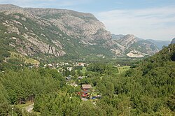
Dirdal is a village in Gjesdal municipality in Rogaland county, Norway. The village is located where the Frafjorden joins the main Høgsfjorden. The village lies at the end of the Dirdalen valley, which stretches to the southeast from Dirdal. The village of Gilja lies about 5 kilometres (3.1 mi) into the valley. The village of Oltedal lies about 8 kilometres (5.0 mi) west of Dirdal. Dirdal Church is located in the village.

Hommersåk is a village in Sandnes municipality in Rogaland county, Norway. The village is located in the borough of Riska in the northern part of the municipality. It is situated about 12 kilometres (7.5 mi) northeast of the city centre of Sandnes, along the shore of the Riskafjorden, an arm off the main Gandsfjorden. The 2.14-square-kilometre (530-acre) village has a population (2015) of 6,312; giving the village a population density of 2,950 inhabitants per square kilometre (7,600/sq mi).
Edlandsvatnet is a lake in the municipality of Gjesdal in Rogaland county, Norway. The 2.11-square-kilometre (0.81 sq mi) lake lies just south of the large village of Ålgård, immediately southwest of the lake Limavatnet. The European route E39 highway runs along the northern shore of the lake. The lake empties into the river Figgjoelva on the northwestern end of the lake. The lake has many brown trout in it.

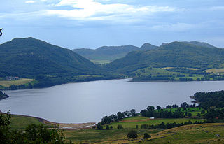
Limavatnet is a lake in the municipality of Gjesdal in Rogaland county, Norway. The 1.73 km2 (0.67 sq mi) lake lies between the villages of Ålgård and Gjesdal. On the western end of the lake, the European route E39 highway crosses the lake on the Vaula Bridge. The lake Edlandsvatnet lies immediately to the west of the bridge.
Flassavatnet is a lake in Rogaland county, Norway. The lake lies on the border of the municipalities of Gjesdal and Sandnes. The 0.9243-square-kilometre (0.3569 sq mi) lake sits about 1 kilometre (0.62 mi) north of the large village of Ålgård, not far north of the lakes Edlandsvatnet and Limavatnet. The lake is a reservoir with a small dam on the southern edge of the lake. The water level is kept at about 177 metres (581 ft) above sea level. The reservoir holds about 900,000 cubic metres.
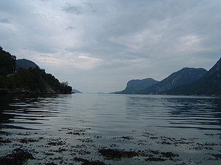
Høgsfjorden is a fjord in Rogaland county, Norway. The innermost part of the fjord is located at the village of Frafjord in the municipality of Gjesdal. It flows west to Dirdal and then heads northwards. At the village of Forsand, the Lysefjord branches off to the northeast. The Høgsfjorden continues to the northwest past the islands of Idsal and Idse before emptying into the Horgefjorden and ultimately into the vast Boknafjorden. The fjord runs through the municipalities of Gjesdal, Forsand, Sandnes, and Strand.

Gilja is a village in Gjesdal municipality in Rogaland county, Norway. The village is located about 5 kilometres (3.1 mi) southeast of the village of Dirdal in the Dirdalen valley. The Frafjord Tunnel connects Gilja with the village of Frafjord, located in the next valley on the other side of the mountains.

Gjesdal is a small farming village in Gjesdal municipality in Rogaland county, Norway. The village is located just southeast of the lake Limavatnet and about 8 kilometres (5.0 mi) east of the municipal centre of Ålgård. The village is the site of Gjesdal Church. The area is locally referred to as Bygda.

Oltedal Church is a parish church in Gjesdal municipality in Rogaland county, Norway. It is located in the village of Oltedal. The church is part of the Gjesdal parish in the Jæren deanery in the Diocese of Stavanger. The white, concrete church was built in 2002 by the architect Olav Urstad. The church was consecrated on 10 February 2002.
Øvrebygd is a small village in Bjerkreim municipality in Rogaland county, Norway. The village is located about 10 kilometres (6.2 mi) northeast of the municipal centre of Vikeså along the road leading to the neighboring municipality of Gjesdal. Ivesdal Chapel is located in this village. The village lies on the north shore of the lake Hofreistæ and the lake Byrkjelandsvatnet lies less than 2 kilometres (1.2 mi) to the north.