Ombella-M'Poko

Last updated
Ombella-M'Poko
Central African Republic - Ombella-M'Poko.svg
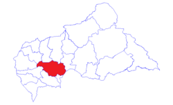
Ombella-M'Poko, prefecture of Central African Republic
Ombella-M'Poko sub-prefectures.png
Sub-prefectures of Ombella-M'Poko
Country Central African Republic
Capital Boali
Area
  Total31,835 km2 (12,292 sq mi)
Population
 (2003 census)
  Total155,438
  Density4.9/km2 (13/sq mi)

Ombella-M'Poko is one of the 20 prefectures of the Central African Republic. [1] [2] Its capital is Boali since 10 December 2020. [3] One important tourist attraction is the Falls of Boali; however, due to the Boali dam, the falls only carry water on the weekends.

Geography

The prefecture lies in the southwestern part of the country and borders the prefectures of Ouham to the north; Lobaye to the south; Ouham-Pendé, Nana-Mambéré, and Mambéré-Kadéï to the west; and Kémo, as well as the independent city of Bangui and the Democratic Republic of the Congo to the east.

Lake Manuela is also located in this region.

Related Research Articles

<span class="mw-page-title-main">Prefectures of the Central African Republic</span> Administrative districts of the Central African Republic

Since 10 December 2020, The Central African Republic is administratively divided into 20 prefectures and the capital city of Bangui, which is an autonomous commune.

<span class="mw-page-title-main">Lobaye</span> Prefecture of the Central African Republic

Lobaye is one of the 20 prefectures of the Central African Republic. Its capital is Mbaïki. Emperor Duy Tân of Vietnam died here on December 26, 1945 in a plane crash. David Dacko, the first and third president of the Central African Republic from 1960–1965 and 1979–1981, was from Lobaye.

<span class="mw-page-title-main">Nana-Mambéré</span> Prefecture of the Central African Republic

Nana-Mambéré is one of the 20 prefectures of the Central African Republic. It covers an area of 26,600 km2 and has a population of 233,666 (2003 census). The capital is Bouar. It was part of Kamerun when it was a German colony between 1884 and 1916.

<span class="mw-page-title-main">Ouham</span> Prefecture of the Central African Republic

Ouham is one of the 20 prefectures of the Central African Republic. Its capital is Bossangoa.

<span class="mw-page-title-main">Ouham-Pendé</span> Prefecture of the Central African Republic

Ouham-Pendé is one of the 20 prefectures of the Central African Republic. Its capital is Bozoum. The region contains several ghost towns such as Goroumo, Beogombo Deux and Paoua due to government forces ransacking them and armed bandits killing all the male inhabitants over the years from 2005 to 2008.

<span class="mw-page-title-main">Bouar</span> Place in Nana-Mambéré, Central African Republic

Bouar is a market town in the western Central African Republic, lying on the main road from Bangui (437 km) to the frontier with Cameroon (210 km). The city is the capital of Nana-Mambéré prefecture, has a population of 40,353, while the whole sous-préfecture has a population of 96,595. Bouar lies on a plateau almost 1000m above sea level and is known as the site of Camp Leclerc, a French military base.

<span class="mw-page-title-main">Berbérati</span> Place in Mambéré-Kadéï, Central African Republic

Berbérati is the second-largest city in the Central African Republic, with a population of 105,155. Located in the south-west of the country, near the border with Cameroon, it serves as capital of the Mambéré-Kadéï Prefecture and the Berbérati sub-prefecture.

Batangafo is a town located in the Central African Republic prefecture of Ouham-Fafa at the confluence of Ouham River and its affluent Fafa.

Bimbo is located 25.5 kilometres (15.8 mi) by road southwest of the centre of the capital, Bangui. The country's second-largest city, Bimbo had a population of 124,176 as of the 2003 census and a calculated 2013 population of 267,859. Bimbo used to be the capital city of Ombella-M'Poko until December 2020. Since December 2020, Bimbo has been part of Bangui Prefecture.

Carnot is a city located in the south west of the Central African Republic (CAR), in the prefecture of Mambéré.

<span class="mw-page-title-main">Paoua</span> Place in Lim-Pendé, Central African Republic

Paoua is a town located in the Central African Republic prefecture of Lim-Pendé.The town is the birthplace of the former president of the Central African Republic, Ange-Félix Patassé.

The Central African Republic is divided into 20 prefectures and one autonomous commune. The prefectures (préfectures) are further divided into 84 sub-prefectures (sous-préfectures).

<span class="mw-page-title-main">Health in the Central African Republic</span>

Health in the Central African Republic has been degraded by years of internal conflict and economic turmoil since independence from France in 1960. One sixth of the country's population is in need of acute medical care. Endemic diseases put a high demand on the health infrastructure, which requires outside assistance to sustain itself.

Nana-Bakassa is a sub-prefecture of Ouham in the Central African Republic.

Bossemptélé is a sub-prefecture of Ouham-Pendé in the Central African Republic.

The following is a timeline of events during the Central African Republic Civil War.

<span class="mw-page-title-main">Lim-Pendé</span> Prefecture of the Central African Republic

Lim-Pendé is a prefecture in Central African Republic. In 2022, the prefecture had a population of around 442,151. The size of Lim-Pendé is 13,210 km2. Paoua is the capital of the prefecture.

<span class="mw-page-title-main">Mambéré</span> Prefecture of the Central African Republic

Mambéré is a prefecture in the Central African Republic. In 2022, the prefecture had a population of around 265,479. Mambéré has a size of 15,740 km2. Carnot is the capital of the prefecture. It is named for the Mambéré River.

<span class="mw-page-title-main">Ouham-Fafa</span> Prefecture of the Central African Republic

Ouham-Fafa is a prefecture in Central African Republic. With an area of 32,530 km2, the prefecture had a population of 225,479 in 2022. Batangafo is the capital of Ouham-Fafa.

References

  1. "Population Prefecture". stat-centrafrique.com. Archived from the original on 26 June 2015. Retrieved 2 February 2012.
  2. "Central African Republic Prefectures". statoids.com. Retrieved 2 February 2012.
  3. Oubangui Médias, Oubangui Médias. "La Centrafrique dispose désormais de 20 préfectures et de 84 sous-préfectures". oubanguimedias.com. Oubangi Medias. Retrieved 27 May 2023.

5°0′N18°0′E / 5.000°N 18.000°E / 5.000; 18.000