Related Research Articles

Ongole is a city in Prakasam district of the Indian state of Andhra Pradesh. It is the headquarters of Prakasam district. It is famous for Ongole cattle, an indigenous breed of oxen.

Prakasamdistrict is one of the twelve districts in the coastal Andhra region of the Indian state of Andhra Pradesh. It was formed in 1970 and reorganised on 4 April 2022. The headquarters of the district is Ongole. It is located on the western shore of Bay of Bengal and is bounded by Bapatla district and Palnadu districts in the north, Nandyal district in the west, Kadapa and Nellore districts in the south. A part of north west region also borders with Nagarkurnool district of Telangana. It is the largest district in the state with an area of 14,322 km2 (5,530 sq mi) and had a population of 22,88,026 as per 2011 Census of India.

Markapuram is a town in Prakasam district of the Indian state of Andhra Pradesh. It is a municipality and is the headquarters of Markapuram mandal in Markapuram revenue division. Markapuram is notable for the Chennakesava Swamy Temple, built by King Sri Krishnadevaraya. During Ratha Yatra there occurs a popular carnival; the town is also famous for Chenna Kesavaswamy on the day of Rathsapthami, which is attended by thousands of people coming from different parts of the state. It is the second-largest town in Prakasam district after Ongole and it is the main place within West Prakasam district to avail all facilities.
Kandukur or Kandukuru is a town in SPSR Nellore district of the Indian state of Andhra Pradesh. It is a municipality and the headquarters of Kandukur mandal as well as Kandukur revenue division. Kandukur Mandal is located at the south-east side of the Prakasam District having geographical area around 225 km2.There is only 1 city in the Kandukur Mandal, which is Kandukur Municipality having an area of 37.63 km2.

Donakonda is a town in the Prakasam district of the Indian state of Andhra Pradesh.

Kanigiri is a town in Prakasam district of the Indian state of Andhra Pradesh. It is a municipality and the headquarters of Kanigiri mandal in Kanigiri revenue division.
Naguluppalapadu is a village in Prakasam district of the Indian state of Andhra Pradesh. It is the mandal headquarters of Naguluppalapadu mandal in Ongole revenue division.

Parchur or Parchuru is a town and an Assembly constituency in Bapatla district of Andhra Pradesh, India. It is also the mandal headquarters of Parchur mandal in chirala revenue division.

Podili is a Municipality Town in Prakasam district of the Indian state of Andhra Pradesh. It is the mandal headquarters of Podili mandal. Podili is also known as Prudulapuri. Before British rule its name was "Prudulapuri" meaning "Head quarters of the universe". There is purana reference to this related to Prudhu Chakravarthi.

Andhra Pradesh lies between 12°41' and 19.07°N latitude and 77° and 84°40'E longitude, and is bordered by Telangana to the north and west, Chhattisgarh to the north-west, Orissa to the north, the Bay of Bengal to the east, Tamil Nadu to the south and Karnataka to the southwest and west. Andhra Pradesh has a coastline of around 974 km, which gives it the second longest coastline in the nation. Two major rivers, the Godavari and the Krishna run across the state. A small enclave 12 sq mi (30 km²), the Yanam district of Puducherry, lies in the Godavari Delta in the north east of the state. The state includes the eastern part of Deccan plateau as well as a considerable part of the Eastern Ghats.
Venkatapuram is a village in the Addanki Mandal of the Prakasam district in the Indian state of Andhra Pradesh.
Manduvavaripalem is a small village in Ongole mandal, Prakasam district in the state of Andhra Pradesh, India. It is 3 km (1.9 mi) from Ongole towards Guntur on NH 16. The village has become in the limelight as Andhra Pradesh's main opposition Telugu Desam Party (TDP) held its 'Mahandu- 2022' or annual conclave in this village Manduvavaripalem near Ongole on 27 & 28 May 2022.
Guntur Urban mandal was a former mandal in Guntur district of the Indian state of Andhra Pradesh, before it was split into Guntur East and Guntur West mandals in 2018. It was under the administration of Guntur revenue division and its headquarters at Guntur, The mandal was bounded by Medikonduru, Tadikonda, Pedakakani, Edlapadu, Prathipadu, Vatticherukuru and Chebrole mandals.
Ongole mandal is one of the 56 mandals in Prakasam district of the state of Andhra Pradesh, India. It is administered under Ongole revenue division and its headquarters are located at Ongole. The mandal is bounded by Naguluppalapadu, Maddipadu, Santhanuthlapadu, and Kothapatnam Tangutur mandals. The mandals lies on the shore of Bay of Bengal.
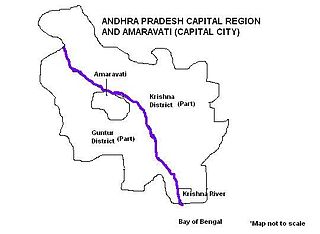
Andhra Pradesh Capital Region is the metropolitan area of the de facto capital city Amaravati of Andhra Pradesh in India. The region is spread across the districts of NTR, Krishna, Guntur, Palnadu, Bapatla and Eluru. It includes the major ancient cities of Vijayawada, Guntur and Tenali. Vijayawada is the largest city and headquarters of the region. It is one the most populated metropolitan areas in Andhra Pradesh. The region is under the jurisdiction of Andhra Pradesh Capital Region Development Authority and covers an area of 8,352.69 km2 (3,224.99 sq mi) under 58 mandals . The de facto capital city Amaravati is an urban notified area and will cover 217.23 km2 (83.87 sq mi), within the Andhra Pradesh Capital Region.
National Highway 216 is a National Highway in the Indian state of Andhra Pradesh. The former highways of NH 214 and 214A were merged and renumbered as NH 216. It starts from NH 16 junction at Kattipudi and passes through Kakinada, Amalapuram, Digamarru (Palakollu), Narasapuram, Machilipatnam, Repalle, Cherukupalle, Bapatla, Chirala before it junctions NH 16 again at Ongole. Visakhapatnam–Kakinada Petro Chemical Corridor, is a proposed project along the highway.
K. Rajupalem is a village in Prakasam district of Andhra Pradesh in India. It belongs to Ballikurava, Martur mandals and is inhabited by approximately 5371 people.

Vykuntapuram, also spelled as Vaikuntapuram, is a village in Guntur district of the Indian state of Andhra Pradesh. It is located in Amaravathi mandal of Guntur revenue division. The village forms a part of Andhra Pradesh Capital Region, under the jurisdiction of APCRDA.

Guntur West mandal is one of the 18 mandals in Guntur district of the Indian state of Andhra Pradesh. It is under the administration of Guntur revenue division and was formed by bifurcating Guntur urban mandal into Guntur East and Guntur West, with its headquarters at Guntur.
Guntur East mandal is one of the 18 mandals in Guntur district of the Indian state of Andhra Pradesh. It is under the administration of Guntur revenue division and was formed by bifurcating Guntur urban mandal into Guntur East and Guntur West, with its headquarters at Guntur.
References
- ↑ "Constitution of Chittoor Urban Development Authority" (PDF). Director of Town and Country Planning. Municipal Administration and Urban Development, Andhra Pradesh. 12 February 2019. Retrieved 12 June 2019.
| | This article about government in India is a stub. You can help Wikipedia by expanding it. |