Kinshasa, formerly Léopoldville, is the capital and the largest city of the Democratic Republic of the Congo. Once a site of fishing and trading villages situated along the Congo River, Kinshasa is now one of the world's fastest growing megacities.

The Democratic Republic of the Congo, informally Congo-Kinshasa, DR Congo, the DRC, the DROC, or the Congo, and formerly and also colloquially Zaire, is a country in Central Africa. It is bordered to the northwest by the Republic of the Congo, to the north by the Central African Republic, to the northeast by South Sudan, to the east by Uganda, Rwanda and Burundi, and by Tanzania, to the south and southeast by Zambia, to the southwest by Angola, and to the west by the South Atlantic Ocean and the Cabinda exclave of Angola. By area, it is the second-largest country in Africa and the 11th-largest in the world. With a population of around 108 million, the Democratic Republic of the Congo is the most populous officially Francophone country in the world. The capital and largest city is Kinshasa, which is also the nation's economic center.

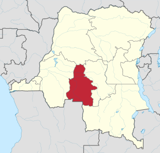
Bandundu is one of eleven former provinces of the Democratic Republic of the Congo. It bordered the provinces of Kinshasa and Bas-Congo to the west, Équateur to the north, and Kasai-Occidental to the east. The provincial capital is also called Bandundu.

Équateur was a province in the northwest of the Belgian Congo and the successor Republic of the Congo, now known as Democratic Republic of the Congo. It had its origins in the Équateur District of the Congo Free State, the private property of King Leopold II of Belgium. It was upgraded to the status of a province in 1917. Between 1933 and 1947 it was named Coquilhatville. In 1962 it was divided into three smaller provinces, but there were recombined in 1966. Équateur was one of the eleven provinces of the Democratic Republic of the Congo until 2015, when it was split into the new, smaller Équateur province, as well as the Tshuapa, Mongala, Nord-Ubangi and Sud-Ubangi provinces.

Kasaï-Occidental was one of the eleven provinces of the Democratic Republic of the Congo between 1966 and 2015, when it was split into the Kasaï-Central and the Kasaï provinces.

Kisangani is the capital of Tshopo province in the Democratic Republic of the Congo. It is the fifth most populous urban area in the country, with an estimated population of 1,312,000 in 2021, and the largest of the cities that lie in the tropical woodlands of the Congo.

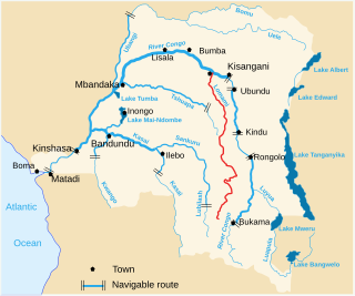
The Lomami River is a major tributary of the Congo River in the Democratic Republic of the Congo. The river is approximately 1,280 km (800 mi) long. It flows north, west of and parallel to the upper Congo.

Équateur is one of the 21 new provinces of the Democratic Republic of the Congo created in the 2015 repartitioning. Équateur, Mongala, Nord-Ubangi, Sud-Ubangi, and Tshuapa provinces are the result of the dismemberment of the former Équateur province. The new province was formed from the Équateur district and the independently administered city of Mbandaka which retained its status as a provincial capital.

Article 2 of the Constitution of the Democratic Republic of the Congo divides the country into the capital city of Kinshasa and 25 named provinces. It also gives the capital the status of a province. Therefore, in many contexts Kinshasa is regarded as the 26th province.

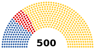
The National Assembly is the lower house and main legislative political body of the Parliament of the Democratic Republic of the Congo. It was established by the 2006 constitution.

The Republic of the Congo, also known as Congo-Brazzaville, the Congo Republic or simply either Congo or the Congo, is a country located in the western coast of Central Africa to the west of the Congo river. It is bordered to the west by Gabon, to its northwest by Cameroon and its northeast by the Central African Republic, to the southeast by the Democratic Republic of the Congo, to its south by the Angolan exclave of Cabinda and to its southwest by the Atlantic Ocean.
Lokilo is a community in the Opala Territory of the Tshopo Province of the Democratic Republic of Congo.
Opala is a territory in the Tshopo Province of the Democratic Republic of the Congo.
Ilambi is a community in the Tshopo Province of the Democratic Republic of the Congo, on the Lomami River. It is 20 kilometres (12 mi) to the south of the point where the Lomani enters the Congo River. Most of the inhabitants are Topoke people.
Yatolema is a village in the Opala Territory of the Tshopo Province of the Democratic Republic of the Congo. It is on the N7 road which connects it to Kisangani to the east. Yatolema is about 58 miles (93 km) from Kisangani. It has a weekly market where local people can exchange goods with traders from the city. The village serves the surrounding area with a rural health center.

Bas-Uélé is one of the 21 new provinces of the Democratic Republic of the Congo created in the 2015 repartitioning. Bas-Uélé, Haut-Uélé, Ituri, and Tshopo provinces are the result of the dismemberment of the former Orientale Province. Bas-Uélé was formed from the Bas-Uele District whose town of Buta was elevated to capital city of the new province.

Haut-Uélé is one of the 21 new provinces of the Democratic Republic of the Congo created in the 2015 repartitioning. Haut-Uélé, Bas-Uélé, Ituri, and Tshopo provinces are the result of the dismemberment of the former Orientale province. Haut-Uélé was formed from the Haut-Uélé district whose town of Isiro was elevated to capital city of the new province.

Tshopo is one of the 21 new provinces of the Democratic Republic of the Congo created in the 2015 repartitioning. It is situated in the north central part of the country on the Tshopo River, for which it is named.

The Katanga insurgency refers to the ongoing rebellion by a number of rebel groups in the Democratic Republic of the Congo, some of which aim for the creation of a separate state within Katanga. While the insurgency has been active in various forms since 1963, insurgent groups have recently redoubled their efforts after the 2011 jail break that freed Gédéon Kyungu Mutanga, who commanded the majority of the Katangese separatist groups until his surrender to Congolese authorities in October 2016.


