Related Research Articles

Coromandel, also called Coromandel town to distinguish it from the wider district, is a town on the Coromandel Harbour, on the western side of the Coromandel Peninsula, which is in the North Island of New Zealand. It is 75 kilometres east of the city of Auckland, although the road between them, which winds around the Firth of Thames and Hauraki Gulf coasts, is 190 km long. The population was 1,750 as of June 2018.
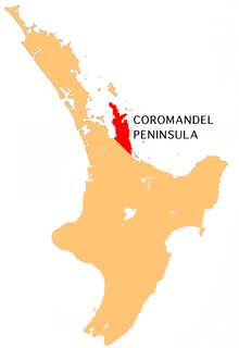
The Coromandel Peninsula on the North Island of New Zealand extends 85 kilometres north from the western end of the Bay of Plenty, forming a natural barrier to protect the Hauraki Gulf and the Firth of Thames in the west from the Pacific Ocean to the east. It is 40 kilometres wide at its broadest point. Almost the entire population lies on the narrow coastal strips fronting the Hauraki Gulf and the Bay of Plenty. In clear weather the peninsula is clearly visible from Auckland, the country's biggest city, which lies on the far shore of the Hauraki Gulf, 55 kilometres to the west. The peninsula is part of the Thames-Coromandel District of the Waikato Region.
Moturoa / Rabbit Island is a small island that lies across the southernmost part of Tasman Bay, on the northern coast of New Zealand's South Island. The long narrow island runs east-west for 8 kilometres (5 mi), and covers 15 km2 (5.8 sq mi).

Te Rerenga is a locality on the Whangapoua Harbour, Coromandel Peninsula, New Zealand. State Highway 25 runs through it. Coromandel is 12 km to the west. Whitianga lies to the south east. The Waitekuri and Opitonui Rivers flow from the Coromandel Range in the west and south through the area to drain in the Whangapoua Harbour.
Whenuakite is a locality on the Coromandel Peninsula of New Zealand. State Highway 25 runs through it. Whitianga is north west, Coroglen 8 km west, Cooks Beach and Hahei north, Hot Water Beach north east, and Tairua 18 km to the south east. The Whenuakite River flows from coastal hills in the east through the area to drain in the Whitianga Harbour.
Matarangi is a small modern tourist town on the Coromandel Peninsula of New Zealand, with around 300 permanent residents increasing to over 7000 holiday residents during the summer period of late December to February. It was developed in the 1980s as a purpose built resort town and occupies a white sand spit between the Whangapoua Harbour and historic Mercury Bay.
The Kaimarama River is a river of New Zealand's Coromandel Peninsula. It flows from its source within Coromandel Forest Park, joining with the Mahakirau River to flow into Whitianga Harbour on the peninsula's east coast.
The Kapowai River is a river in the Waikato Region of New Zealand. It is located on the Coromandel Peninsula, and flows north from its source inland from Tairua, reaching the sea at Whitianga Harbour
The Kuaotunu River is a short river on the eastern Coromandel Peninsula on the North Island of New Zealand. It flows north towards the coast at Kuaotunu.
The Mahakirau River is a river of the Coromandel Peninsula in New Zealand's North Island. It flows east from its source in the Coromandel Range, reaching the sea at Whitianga Harbour southwest of Whitianga.
The Manaia River is a river of the Coromandel Peninsula in New Zealand's North Island. It flows north from its sources in the Coromandel Range, reaching the waters of the Hauraki Gulf at Manaia Harbour, 10 kilometres (6 mi) southwest of Coromandel.
The Ounuora River is a river of the Coromandel Peninsula in the Waikato Region of New Zealand's North Island. It flows generally east from the Coromandel Range, reaching the Whitianga Harbour close to the small settlement of Mill Creek, 5 kilometres (3 mi) southwest of Whitianga.
The Purangi River is a river of the Coromandel Peninsula in New Zealand's North Island. It flows north to reach Mercury Bay to the east of Whitianga.
The Waitekuri River is a river of the Coromandel Peninsula in New Zealand's North Island. It flows east from its sources in the Coromandel Range east of Coromandel to reach Whangapoua Harbour four kilometres south of Whangapoua.
The Waiwawa River is the longest river on the Coromandel Peninsula, in the Waikato Region of New Zealand's North Island. It flows initially northwest from its sources on the slopes of Mount Rowe before turning northeast to reach the southern end of the Whitianga Harbour.
The Whangamaroro River is a short river of the Coromandel Peninsula, in the Waikato Region of New Zealand's North Island. It flows east to reach a northwestern arm of Whitianga Harbour
The Whenuakite River is one of the longer rivers on the Coromandel Peninsula, in the Waikato Region of New Zealand's North Island. It flows initially north from its sources close to the peninsula's southeast coast north of Tairua, before turning west to reach the southernmost point of the Whitianga Harbour.

Whangapoua is a small settlement of mostly holiday houses on the Coromandel Peninsula of New Zealand. It is situated 25 minutes drive east over the Coromandel Range from Coromandel along the northeastern coastline encompassing popular white sand beaches New Chums Beach, Matarangi, Kuaotunu Beach and Otama Beach.

Whangapoua Harbour is a shallow natural harbour in the northeast of the Coromandel Peninsula. It is located between Whangapoua in the north, Te Rerenga in the southwest, and Matarangi on the Omara Spit in the north separating it from the ocean. Two boat ramps and a jetty provide boat access into the harbour.
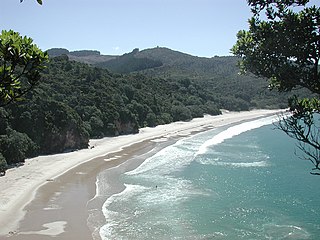
New Chums Beach is a beach in the Wainuiototo Bay on the northeast coast of the Coromandel Peninsula, New Zealand, near Whangapoua.
References
"Place name detail: Opitonui River". New Zealand Gazetteer. Land Information New Zealand . Retrieved 12 July 2009.
Coordinates: 36°45′S175°37′E / 36.750°S 175.617°E
| This article about a river in the Waikato Region is a stub. You can help Wikipedia by expanding it. |