
Stryn is a municipality in the county of Sogn og Fjordane, Norway. It is located in the traditional district of Nordfjord. The administrative center of the municipality is the village of Stryn. The municipality is located along the innermost part of the Nordfjorden. Some of the main villages in Stryn include Loen, Innvik, Utvik, Randabygda, Olden, and Flo.

Nordfjord is a traditional district of Norway.

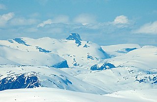
Myklebustbreen or Snønipbreen is the seventh largest glacier in mainland Norway. It is located in the municipalities of Jølster, Gloppen, and Stryn in Sogn og Fjordane county. Its highest point is located just below the nunatak Snønipa, with an altitude of 1,827 metres (5,994 ft). The lowest point on the glacier is at an elevation of 890 metres (2,920 ft) above sea level.

Flo is a small village in the municipality of Stryn in Sogn og Fjordane county, Norway. It is located on the northern shore of the lake Oppstrynsvatn, about 18 kilometres (11 mi) east of the municipal center of Stryn. Directly south across the lake is the Jostedalsbreen nasjonalparksenter, a visitor's center for the nearby Jostedalsbreen National Park.

Oppstrynsvatn is a lake in the municipality of Stryn in Sogn og Fjordane county, Norway. It is located about 8 kilometres (5.0 mi) east of the village of Stryn. The villages of Flo, Oppstryn, and Erdal are located on the shores of the lake.

Loen is a village in Stryn Municipality in Sogn og Fjordane county, Norway. It is located in the inner part of the Nordfjord region, at the easternmost end of the Nordfjorden. Loen is located about 6 kilometres (3.7 mi) north of the village of Olden and about 11 kilometres (6.8 mi) southeast of the municipal center of Stryn. The lake Lovatnet is located just to the southeast of the village of Loen. The Hotel Alexandra was established in Loen in 1884. The historic Loen Church is also located in the village.

Lovatnet is a lake in the municipality of Stryn in Sogn og Fjordane county, Norway. It is located about 2 kilometres (1.2 mi) southeast of the village of Loen and about 6 kilometres (3.7 mi) east of the village of Olden. The lake lies just 2 kilometres (1.2 mi) southwest of the mountain Skåla. The water from the lake flows down from the mountains; especially from the Jostedalsbreen and Tindefjellbreen glaciers. It then flows out through the Loelva river into the Nordfjorden.
Lodalskåpa is the highest nunatak on the glacier Jostedalsbreen. It is located on the border between the municipalities of Stryn and Luster in Sogn og Fjordane county, Norway, within Jostedalsbreen National Park.

Jostedalsbreen nasjonalparksenter is a visitors center that is located in the village of Oppstryn in the municipality of Stryn in Sogn og Fjordane county, Norway. The center is located east of the villages of Loen and Olden, on the shore of the lake Oppstrynsvatn. The mountain Skåla and the glaciers Briksdalsbreen and Jostedalsbreen are located to the southwest of this visitor's center.
Tindefjellbreen is a glacier in the municipality of Stryn in Sogn og Fjordane county, Norway. The 20-square-kilometre (7.7 sq mi) glacier lies about 4 kilometres (2.5 mi) east of the mountain Skåla, roughly halfway between the villages of Bødalen and Erdalen. The glacier is in the mountains east of the lake Lovatnet and south of the lake Oppstrynsvatn. The glacier is part of Jostedalsbreen National Park, about 10 kilometres (6.2 mi) east of the village of Loen.
Olden is a village and urban area in the municipality of Stryn in Sogn og Fjordane county, Norway. Olden is located at the mouth of the Oldeelva river at the northern end of the Oldedalen valley on the southern shore of the Nordfjorden. The 0.57-square-kilometre (140-acre) village has a population (2013) of 498, giving the village a population density of 874 inhabitants per square kilometre (2,260/sq mi). Olden is located about 6 kilometres (3.7 mi) southwest of the village of Loen, about a 16 kilometres (9.9 mi) drive southeast of the municipal center of Stryn, and about 15 kilometres (9.3 mi) east of the village of Innvik.
Tystigbreen is a glacier that is located on the border between Sogn og Fjordane and Oppland counties in Norway. The 21-square-kilometre (8.1 sq mi) glacier is located in the municipalities of Stryn and Skjåk, about 10 kilometres (6.2 mi) east of the lake Oppstrynsvatnet. The Norwegian National Road 15 passes the northwest side of the glacier. A summer ski center is located at the glacier.
Eimhjellevatnet or Emhjellevatnet is a lake in Hyen area of Gloppen Municipality in Sogn og Fjordane county, Norway. The 11.39-square-kilometre (4.40 sq mi) lake is located in the western part of the municipality near the border with Flora Municipality. The villages of Eimhjellen and Solheim can be found along its shore and the village of Straume lies about 15 kilometres (9.3 mi) to the north. The lake lies about 25 kilometres (16 mi) southwest of the municipal center of Sandane. It is the second largest lake in all of Gloppen municipality and it has a good population of trout for fishing.

Oldedalen is a river valley in Stryn Municipality in Sogn og Fjordane county, Norway. The 20-kilometre (12 mi) long valley runs north-south and ends at the Nordfjorden at the village of Olden. The south end of the valley reaches up to the great Jostedalsbreen glacier inside Jostedalsbreen National Park. The small Briksdalsbreen is a smaller arm that branches off the main Jostedalsbreen glacier, and it sits at the end of the Oldedalen valley. It is a tourist attraction due to its easy to reach location. The western side of the valley is a fairly steep wall of mountains with the Myklebustbreen glacier at the top.
Innvik is a village in Stryn Municipality in Sogn og Fjordane county, Norway. The village is located on the southern shore of the Nordfjorden. The village is located about 15 kilometres (9.3 mi) west of the village of Olden and about 7 kilometres (4.3 mi) northeast of the village of Utvik. Directly across the fjord from Innvik lies the village of Roset.

Stryn is the administrative centre of Stryn Municipality in Sogn og Fjordane county, Norway. The village is located on the shore of a small bay off of the main Nordfjorden. The mouth of the river Stryneelva is in the village. The village sits about 3.5 kilometres (2.2 mi) west of the village of Nedstryn.
Roset or Nordsida is a village in Stryn Municipality in Sogn og Fjordane county, Norway. The village is located on the northern shore of the Nordfjorden. The village is located about 15 kilometres (9.3 mi) east of the village of Randabygda and about 15 kilometres (9.3 mi) west of the village of Stryn. The village of Innvik lies directly across the Nordfjorden from Roset. Nordsida Church is located in Roset.

Randabygda or Hopland is a village in Stryn Municipality in Sogn og Fjordane county, Norway. The village is located on the northern shore of the Nordfjorden on a rather steep sloping area along the fjord. The village lies about 15 kilometres (9.3 mi) east of the village of Lote and about 15 kilometres (9.3 mi) west of the village of Roset. Randabygda Church is located in this village. The village is divided by the river Hoplandselva, where Hopland lies to the west and Randabygda lies to the east.

Utvik is a village in Stryn Municipality in Sogn og Fjordane county, Norway. The village is located on the southern shore of the Nordfjorden. The village lies about 7 kilometres (4.3 mi) southwest of the village of Innvik and about 10 kilometres (6.2 mi) north of the village of Byrkjelo. Utvik Church is located in this village. Historically, the village was an important trading post and ferry port with a regular route across the fjord. The ferry was stopped in 1936 when the new road was completed along the Nordfjorden connecting Utvik to the village of Stryn.

Nedstryn is a village in Stryn Municipality in Sogn og Fjordane county, Norway. The village is located along the river Stryneelva, about 3.5 kilometres (2.2 mi) east of the village of Stryn and the same distance west of the large lake Oppstrynsvatnet. The small village is home to Nedstryn Church. The church serves all of the residents in the area surrounding the church, including the nearby village of Stryn and the areas north of the lake Oppstrynsvatnet including the village of Flo.


