
Stryn is a municipality in the county of Sogn og Fjordane, Norway. It is located in the traditional district of Nordfjord. The administrative center of the municipality is the village of Stryn. The municipality is located along the innermost part of the Nordfjorden. Some of the main villages in Stryn include Loen, Innvik, Utvik, Randabygda, Olden, and Flo.

Kaupanger is a village situated along the northern shore of the Sognefjorden in the municipality of Sogndal in Sogn og Fjordane county, Norway. It sits along the Norwegian National Road 5, about 12 kilometres (7.5 mi) southeast of the municipal centre of Sogndalsfjøra and about 8 kilometres (5.0 mi) northeast of the Sogndal Airport, Haukåsen. Kaupanger IL is a sports club located in Kaupanger. The 0.87-square-kilometre (210-acre) village has a population (2013) of 931, giving the village a population density of 1,135 inhabitants per square kilometre (2,940/sq mi).

Myra is the administrative centre of the municipality of Vegårshei in Aust-Agder, Norway. The village is located along the river Storelva, which flows out of the large Vegår lake, just to the north. The 0.92-square-kilometre (230-acre) village has a population (2017) of 781 which gives the village a population density of 849 inhabitants per square kilometre (2,200/sq mi).

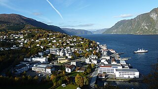
Sogndalsfjøra is the administrative center of the municipality of Sogndal in Sogn og Fjordane county, Norway. It is located where the river Sogndalselvi runs out in the Sogndalsfjorden, a branch of the large Sognefjorden. The village is located about 3.5 kilometres (2.2 mi) northwest of the village of Kjørnes, about 10 kilometres (6.2 mi) northwest of the village of Kaupanger, and about 31 kilometres (19 mi) southeast of the village of Fjærland.

Brandsøy (Brandsoy) is a village in the municipality of Flora in Sogn og Fjordane county, Norway. It is located on both sides of small strait that separates the east end of the island of Brandsøya and the mainland. The village sits along the Norwegian National Road 5 highway, about 6.9 kilometres (4.3 mi) east of the town of Florø and about 10 kilometres (6.2 mi) west of the village of Grov. The 0.4-square-kilometre (99-acre) village has a population (2013) of 420, giving the village a population density of 1,337 inhabitants per square kilometre (3,460/sq mi).
Skei is the administrative centre of the municipality of Jølster in Sogn og Fjordane county, Norway. The village is located at the northeastern end of the lake Jølstravatnet. Skei is 20 kilometres (12 mi) south of the village of Byrkjelo, 25 kilometres (16 mi) northeast of the villages of Vassenden/Langhaugane, and about 13 kilometres (8.1 mi) east of the village of Ålhus. Skei is located just west of Jostedalsbreen National Park. The village lies at the intersection of two major regional highways: European route E39 and Norwegian National Road 5.
Dale or Dale i Sunnfjord is the administrative centre of the municipality of Fjaler in Sogn og Fjordane county, Norway. The village is located at the mouth of the river Vassdalselva on the southern shore of the Dalsfjorden in the northern part of Fjaler, about 6.5 kilometres (4.0 mi) northeast of the village of Flekke and about 20 kilometres (12 mi) west of the village of Bygstad.

Oppstrynsvatn is a lake in the municipality of Stryn in Sogn og Fjordane county, Norway. It is located about 8 kilometres (5.0 mi) east of the village of Stryn. The villages of Flo, Oppstryn, and Erdal are located on the shores of the lake.

Skare or Skarde is a village in Odda municipality in Hordaland county, Norway. The village is located about 15 kilometres (9.3 mi) straight south of the town of Odda and about 5 kilometres (3.1 mi) northwest of the village of Seljestad. The village sits at the junction of Norwegian National Road 13 and European route E134. Skare Church is located in the village. The 0.29-square-kilometre (72-acre) village has a population (2013) of 320, giving the village a population density of 1,103 inhabitants per square kilometre (2,860/sq mi). The Espelandsfossen waterfall lies about 1.5 kilometres (0.93 mi) north of the village, just off the side of the National Road 13.
Olden is a village and urban area in the municipality of Stryn in Sogn og Fjordane county, Norway. Olden is located at the mouth of the Oldeelva river at the northern end of the Oldedalen valley on the southern shore of the Nordfjorden. The 0.57-square-kilometre (140-acre) village has a population (2013) of 498, giving the village a population density of 874 inhabitants per square kilometre (2,260/sq mi). Olden is located about 6 kilometres (3.7 mi) southwest of the village of Loen, about a 16 kilometres (9.9 mi) drive southeast of the municipal center of Stryn, and about 15 kilometres (9.3 mi) east of the village of Innvik.

Båtsfjord is the administrative centre of Båtsfjord Municipality in Finnmark county, Norway. The fishing village is located along the 13-kilometre (8.1 mi) long Båtsfjorden, an inlet from the Barents Sea, along the northern coast of the Varanger Peninsula. The village sits at the northern end of Norwegian County Road 891. The Båtsfjord Airport lies just south of the village. The Hurtigruten coastal express has regular stops at Båtsfjord.

Eide is the administrative centre of Eide Municipality in Møre og Romsdal county, Norway, where it sits on the Romsdal Peninsula at the intersection of the Kornstadfjorden and Kvernesfjorden.
Stranda is the administrative centre of Stranda Municipality in Møre og Romsdal county, Norway. The village is located on the western shore of the Storfjorden. The 2.38-square-kilometre (590-acre) village has a population (2013) of 2,907; giving the village a population density of 1,221 inhabitants per square kilometre (3,160/sq mi), and making it the largest settlement in the municipality.
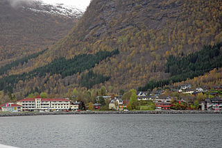
Innvik is a village in Stryn Municipality in Sogn og Fjordane county, Norway. The village is located on the southern shore of the Nordfjorden. The village is located about 15 kilometres (9.3 mi) west of the village of Olden and about 7 kilometres (4.3 mi) northeast of the village of Utvik. Directly across the fjord from Innvik lies the village of Roset.
Naustdal is the administrative centre of Naustdal Municipality in Sogn og Fjordane county, Norway. The village is located on the northern shore of the Førdefjorden at the mouth of the river Nausta, which flows through the Naustdalen valley. The village sits about 12 kilometres (7.5 mi) northwest of the town of Førde and about 10 kilometres (6.2 mi) northeast of the village of Helle. Kletten Hill rises southeast of the village.
Granvin, also known as Eide, is the administrative centre of Granvin municipality in Hordaland county, Norway. The village is located at the head of the Granvin Fjord in the central part of the municipality. The large village of Vossevangen lies about 25 kilometres (16 mi) to the northwest and the village of Ulvik lies about 20 kilometres (12 mi) to the northeast. The 0.71-square-kilometre (180-acre) village has a population (2013) of 426, giving the village a population density of 600 inhabitants per square kilometre (1,600/sq mi).

Eidfjord is the administrative centre of Eidfjord municipality in Hordaland county, Norway. The village is located on the shore of the Eid Fjord, an inner branch of the large Hardangerfjorden. The village sits about 15 kilometres (9.3 mi) east of the Hardanger Bridge along the Norwegian National Road 7.

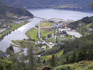
Evje is the administrative centre of Evje og Hornnes municipality in Aust-Agder county, Norway. The village is located along the river Otra. It sits along the Norwegian National Road 9, about 10 kilometres (6.2 mi) south of the village of Byglandsfjorden and immediately north of Evjemoen, a former military base. Historically, the village of Evje was the administrative centre of the municipality of Evje og Vegusdal from 1838 until 1877, then from 1877 until 1960 it was the administrative centre of the municipality of Evje, and since then it has been the centre of Evje og Hornnes municipality.
Klæbu is the administrative centre of Klæbu municipality in Trøndelag county, Norway. The village is located on the eastern shore of the river Nidelva, about 2 kilometres (1.2 mi) east of the village of Tanem and about 15 kilometres (9.3 mi) south of the city of Trondheim. The village sits at the junction of Norwegian county roads 805 and 921. The historic Klæbu Church is located in the village.

Namdalseid is the administrative centre of Namdalseid municipality in Trøndelag county, Norway. The village is located along the Norwegian County Road 17, about 30 kilometres (19 mi) north of the town of Steinkjer and about the same distance south of the town of Namsos. The Namdalseid Church sits just southwest of the village. There's a school in the village as well.


