Rivers Inlet is a fjord in the Central Coast region of the Canadian province of British Columbia, its entrance off Fitz Hugh Sound, about 125 kilometres (78 mi) southwest of the community of Bella Coola and about 65 kilometres (40 mi) north of the northern tip of Vancouver Island and the western entrance of the Queen Charlotte Strait.

The Homathko River is one of the major rivers of the southern Coast Mountains of the Canadian province of British Columbia. It is one of the few rivers that penetrates the range from the interior Chilcotin Country to the coastal inlets of the Pacific Ocean. The Homathko River reaches the sea at the head of Bute Inlet adjacent to the mouth of the Southgate River, just to its east.

Bute Inlet is one of the principal inlets of the British Columbia Coast. It is 80 km long from the estuaries of the Homathko and Southgate Rivers at the head of the inlet, to the mouth, where it is nearly blocked by Stuart Island, and it averages about 4 km in width. Bute Inlet is in a spectacular wilderness setting and is one of the most scenic waterways in the world. In the upper reaches of the inlet mountains rise 9000 feet above sea level. Bute Inlet is a spectacular wilderness that is visited by very few people. In more recent years tourists are travelling from around the world to view grizzly bears in a natural setting and explore the wilderness of Bute Inlet.
Toba Inlet is one of the lesser, but still principal, inlets of the British Columbia Coast. It is fourth in the series north from the 49th parallel which begins with Burrard Inlet, which is the harbour for the city of Vancouver. Between it and Jervis Inlet to its east, however, there is a freshwater fjord, Powell Lake, which has been augmented by a small hydro project to supply power to the large pulp mill at Powell River, the principal town of the Malaspina Peninsula of the upper Sunshine Coast.
Kingcome Inlet is one of the lesser principal fjords of the British Columbia Coast, north and east of Broughton Island. It is sixth in sequence of the major saltwater fjords north from the 49th parallel north near Vancouver and similar in width to longer inlets such as Knight Inlet and Bute Inlet, but it is only 35 km in length from the mouth of the Kingcome River to Sutlej Channel, which ultimately connects around Broughton Island to the main regional waterway of the Queen Charlotte Strait. Kingcome Inlet has a short side inlet, Wakeman Sound, fed by the Wakeman River.
Seymour Inlet is one of the lesser traveled of the principal inlets of the British Columbia Coast. Unlike larger inlets such as Knight or Bute, it is not flanked by mountains but by relatively low, but still rugged, coastal hill-country and forms a maze of complex, narrow waterways and tidal pools and lagoons. It is located within a corresponding maze of peninsulas on the mainland on the northwest side of the Queen Charlotte Strait region.
Loughborough Inlet is one of the lesser principal inlets of the British Columbia Coast. It penetrates the Coast Mountains on the north side of the Discovery Islands archipelago, running about 35 kilometres (22 mi) from its head at the mouth of the Stafford River to Chancellor Channel and Cordero Channel, which are on the north side of West Thurlow Island. A further 14 kilometres (8.7 mi) west along Chancellor Channel is Johnstone Strait.
Bishop River Provincial Park is a provincial park in the Pacific Ranges of the Coast Mountains on the Mainland of British Columbia, Canada, located southwest of and adjoining Ts'yl-os Provincial Park."Bishop River Park". BC Geographical Names. It lies along the upper course of the Bishop River, the main tributary of the Southgate River, from the Bishop's source at the western side of the Lillooet Icecap to midway along its course above its confluence with the Southgate. The park is 19,947 ha. in size. There are no roads or trails in the park although a forest service road from Waddington Harbour at the head of Bute Inlet leads up the Southgate to within a few miles of the park boundary.

Hardy Island Marine Provincial Park is a provincial park in British Columbia, Canada. Hardy and Nelson Island partially 'block' the mouth of Jervis Inlet and Hotham Sound to Malaspina Strait. Hardy Island is flatter in terrain and has the large Blind Bay within it. Blind Bay is an important anchorage for tugboats, tows and marine pleasure craft escaping the weather in Malaspina Strait.

Harmony Islands Marine Provincial Park is a provincial park in British Columbia, Canada, located on the east side of Hotham Sound, which is a side-inlet of the lower reaches of Jervis Inlet, on that inlet's north side roughly opposite the mouth of Sechelt Inlet.
Homathko Estuary Provincial Park is a provincial park in British Columbia, Canada, located at the head of Bute Inlet surrounding the mouth of the Homathko River in the Pacific Ranges of the Coast Mountains.
Denham Island is an islet north of Sonora Island in Cordero Channel, near the mouth of Bute Inlet in British Columbia, Canada.
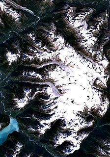
The Homathko Icefield is an icefield in British Columbia, Canada. Officially named the Homathko Snowfield from 1950 until the current name was adopted in 1976, it is one of the largest icefields in the southern half of the Coast Mountains, with an area of over 2,000 km2 (770 sq mi). It is located between Chilko Lake and the Homathko River, and lies across the Great Canyon of that river to the east of the Waddington Range. Although adjacent to Mount Queen Bess, the Homathko Icefield is largely an expanse of ice, about 30 km (19 mi) across, ringed by relatively minor peaks and distinguished, relative to the other Coast Mountains icefields, by lack of any major ones. The Lillooet Icecap and the Compton Névé, both similar in size to the Homathko Icefield but much more peak-studded, lie to the Homathko Icefield's southeast across the Southgate River which bends around the icefield-massif's southern flank to reach the head of Bute Inlet adjacent to the mouth of the Homathko River. The icefield is essentially one large ice-girt montane plateau between these two rivers.

West Redonda Island is an island in British Columbia, Canada. It is part of the Discovery Islands, an archipelago between Vancouver Island and the mainland, and between the Strait of Georgia and Johnstone Strait.
Observatory Inlet is an inlet on the North Coast of British Columbia. It is a northward extension of Portland Inlet, other branches of which include the Portland Canal. The entrance of Observatory Inlet, from Portland Inlet, lies between Ramsden Point and Nass Point. Ramsden Point also marks, to the west, the entrance of Portland Canal. Observatory Inlet was named by George Vancouver in 1793, because he set up his observatory on the shore of the inlet, at Salmon Cove, in order to calibrate his chronometers. His two vessels, HMS Discovery and HMS Chatham, stayed in Salmon Cove from July 23 to August 17, 1793. During this time a boat surveying expedition under Vancouver himself explored Behm Canal. Vancouver also named three headlands at the entrance of Observatory Inlet: Maskelyne Point, for Nevil Maskelyne, the Astronomer Royal, Wales Point, for William Wales, the mathematical master who sailed with James Cook, and Ramsden Point, after the famed mathematical instrument-maker Jesse Ramsden.
Musket Island Marine Provincial Park is a provincial park in British Columbia, Canada, located on the west side of Nelson Island, at the mouth of Jervis Inlet and near Earl's Cove in the Sunshine Coast region.
The Southgate River is a river in the Pacific Ranges of the Coast Mountains in British Columbia, Canada, entering the head of Bute Inlet, on that province's South Coast, just east of the mouth of the Homathko River at Waddington Harbour. The lower reaches of the river's course are flat-bottomed and are named Pigeon Valley. The river is approximately 65 km in length, beginning on the western flank of Good Hope Mountain, to the east of the Homathko Icefield, and then flows generally SSW for about 40 km before turning WNW towards the head of Bute Inlet. The Bishop River enters it from the east after the first 20 km of its course and has its origin at Ring Pass, which lies between the Compton Neve (W) and the Lillooet Icecap (E) and forms the divide with the uppermost Lillooet River.
Lancelot Inlet is an inlet in the Sunshine Coast region of the South Coast of British Columbia, Canada. It is a sidewater of Malaspina Inlet, and immediately east of the Gifford Peninsula. Via Thors Cove on its east side, its own sidewater is Theodosia Inlet, at the head of which is the mouth of the Theodosia River. The locality of Theodosia Arm is located here.
Waddington Harbour is a harbour at the head of Bute Inlet in the Central Coast region of British Columbia, Canada. Also issuing into the head of Bute Inlet and Waddington Harbour, just east of the mouth of the Homathko, is the Teaquahan River. Issuing directly into the inlet a few miles south on the harbour's southeast is the Southgate River, one of the major rivers of the central Pacific Ranges, which begins on the west side of the Lillooet Icecap. Its lower valley adjacent to the inlet's shores is called Pigeon Valley.
The Teaquahan River, formerly Teaquahan Creek, is a river in the Pacific Ranges of the Coast Mountains, flowing into the head of Bute Inlet at Waddington Harbour, immediately east of the mouth of the Homathko River.


