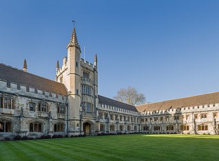
Magdalen College is a constituent college of the University of Oxford. It was founded in 1458 by William of Waynflete. Today, it is the fourth wealthiest college, with a financial endowment of £332.1 million as of 2019 and one of the strongest academically, setting the record for the highest Norrington Score in 2010 and topping the table twice since then. It is home to several of the university's distinguished chairs, including the Agnelli-Serena Professorship, the Sherardian Professorship, and the four Waynflete Professorships.

Brasenose College (BNC) is one of the constituent colleges of the University of Oxford in the United Kingdom. It began as Brasenose Hall in the 13th century, before being founded as a college in 1509. The library and chapel were added in the mid-17th century and the new quadrangle in the late 19th and early 20th centuries.

Corpus Christi College is one of the constituent colleges of the University of Oxford in the United Kingdom. Founded in 1517, it is the 12th oldest college in Oxford.

Hertford College is a constituent college of the University of Oxford in England. It is located on Catte Street in the centre of Oxford, directly opposite the main gate to the Bodleian Library. The college is known for its iconic bridge, the Bridge of Sighs. There are around 600 students at the college at any one time, comprising undergraduates, graduates and visiting students from overseas.

Oriel College is a constituent college of the University of Oxford in Oxford, England. Located in Oriel Square, the college has the distinction of being the oldest royal foundation in Oxford. In recognition of this royal connection, the college has also been historically known as King's College and King's Hall. The reigning monarch of the United Kingdom is the official visitor of the college.
Drury Lane is a street on the eastern boundary of the Covent Garden area of London, running between Aldwych and High Holborn. The northern part is in the borough of Camden and the southern part in the City of Westminster.

Liverpool Road is a street in Islington, North London. It covers a distance of 1+1⁄4 miles (2.0 km) between Islington High Street and Holloway Road, running roughly parallel to Upper Street through the area of Barnsbury. It contains several attractive terraces of Georgian houses and Victorian villas, many of which are listed buildings. There are a number of pubs, small businesses and restaurants along its route, as well as some secluded garden squares. The vast majority of the street is residential, with a bustling shopping and business area at the southern, Angel, end.

St Mary Hall was a medieval academic hall of the University of Oxford. It was associated with Oriel College from 1326 to 1545, but functioned independently from 1545 until it was incorporated into Oriel College in 1902.
Cable Street is a road in the East End of London, England, with several historic landmarks nearby. It was made famous by the Battle of Cable Street in 1936.
Basil Champneys was an English architect and author whose most notable buildings include Manchester's John Rylands Library, Somerville College Library (Oxford), Newnham College, Cambridge, Lady Margaret Hall, Oxford, Mansfield College, Oxford and Oriel College, Oxford's Rhodes Building.

The High Street in Oxford, England, known locally as the High, runs between Carfax, generally seen as the centre of the city, and Magdalen Bridge to the east.
The Oriel Square tennis court was a real tennis court that was located in Oriel Square, central Oxford, England. The Liber Albus mentions the Oriel court being in Vinehall Lane in 1577.

Merton Street is a historic and picturesque cobbled street in central Oxford, England. It joins the High Street at its northeastern end, between the Ruskin School of Drawing and Fine Art and the Eastgate Hotel at the historic east gate of the city. It then runs east–west, parallel and to the south of the High Street for most of its length.

Alfred Street is a street running between the High Street to the north and the junction with Blue Boar Street and Bear Lane at the southern end, in central Oxford, England. To the south is Christ Church, one of Oxford University's historic colleges.
Bear Lane is a short historic street in central Oxford, England. The lane is located just north of Christ Church. It runs between the junction of Blue Boar Street and Alfred Street to the west, and King Edward Street and the north of Oriel Square to the east.
King Edward Street is a street running between the High Street to the north and Oriel Square to the south in central Oxford, England.
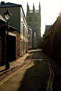
Magpie Lane is a narrow historic lane in central Oxford, England. It leads south from the High Street where it is at its narrowest, now completely pedestrianised as a pavement, and north from the cobbled Merton Street.

Richard Lane was an English architect of the early and mid-19th century. Born in London and based in Manchester, he was known in great part for his restrained and austere Greek-inspired classicism. He also designed a few buildings – mainly churches – in the Gothic style. He was also known for masterplanning and designing many of the houses in the exclusive Victoria Park estate.

Marylebone is a district in the West End of London, in the City of Westminster. Oxford Street, Europe's busiest shopping street, forms its southern boundary.

New Road is a street in west central Oxford, England. It links Park End Street and Worcester Street to the west with Queen Street and Castle Street to the east. To the south is Oxford Castle and the former Oxford Prison, now a Malmaison hotel. To the north is Nuffield College, a graduate college of Oxford University. At the eastern end on the south side is New County Hall, the headquarters of Oxfordshire County Council.

