Gallery
 Orr Street, 1896
 Snow in Orr Street, date unknown
 Looking east up Orr Street, with the post office tower mid right, 2010
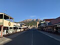 Looking east up Orr Street, post office tower mid right, 2022
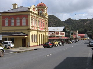
Orr Street, Queenstown is the main street of Queenstown, Tasmania, Australia.
Constructed and utilised by 1901, it had operating banks and hotels such as the prominent Empire Hotel at its western end. It also had many commercial offices and shops until the decline of the local Mount Lyell copper mine in the 1990s.
The junction at the western end is Driffield Street which links to the Lyell Highway.
The street provides a clear view of Mount Owen that lies above Queenstown to the east. At its western end was the original railway station, railway yard and railway that was the main connection with the outside world until completion of roads in the 1930s (those being Lyell Highway and the Queenstown to Zeehan highway).
The street view inspired the local camera club in the 1930s to have a scene from the street in its regular competitions. [1]
Until the bituminization, the street required regular resurfacing. [2]
Many structures remain in the historic streetscape, but are no longer functioning in their original purpose.
The street was named after William Orr (born 1843), who was one of the first major investors in the Mount Lyell Mine.


Queenstown is a town in the West Coast region of the island of Tasmania, Australia. It is in a valley on the western slopes of Mount Owen on the West Coast Range.
West Coast Council is a local government body in Tasmania, covering much of the western region of the state. West Coast is classified as a rural local government area and has a population of 4,167. The major towns and localities of the region include Strahan, Rosebery, Zeehan and the principal town of Queenstown.

Zeehan is a town on the west coast of Tasmania, Australia 139 kilometres (86 mi) south-west of Burnie. It is part of the West Coast Council, along with the seaport Strahan and neighbouring mining towns of Rosebery and Queenstown.

The West Coast of Tasmania is mainly isolated rough country, associated with wilderness, mining and tourism. It served as the location of an early convict settlement in the early history of Van Diemen's Land, and contrasts sharply with the more developed and populous northern and eastern parts of the island state.
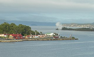
Regatta Point is the location of a port and rail terminus on Macquarie Harbour.

The North East Dundas Tramway was a 2 ft narrow gauge tramway, that ran between Zeehan and Deep Lead on the West Coast of Tasmania. Opening in 1896 and closing in 1932, it was part of the Tasmanian Government Railways network. The world's first Garratt locomotives, the K class, were used on the line.
Crotty is a former gazetted townsite that was located in Western Tasmania, Australia. The township was located on the eastern lower slopes of Mount Jukes, below the West Coast Range, and on the southern bank of the King River. The locality had had a former name of King River
The mines of the West Coast of Tasmania have a rich historical heritage as well as an important mineralogical value in containing or having had found, specimens of rare and unusual minerals. Also, the various mining fields have important roles in the understanding of the mineralization of the Mount Read Volcanics, and the occurrence of economic minerals.
The history of the Railways on the West Coast of Tasmania has fascinated enthusiasts from around the world, because of the combination of the harsh terrain in which the railways were created, and the unique nature of most of the lines.

Linda is the site of an old ghost town in the Linda Valley in the West Coast Range of Tasmania, Australia. It has also been known as Linda Valley.

Mount Murchison is a mountain on the West Coast Range, located in the West Coast region of Tasmania, Australia.
Mount Dundas is a mountain located in the West Coast region of Tasmania, Australia. The mountain is situated at the north west edge of the West Coast Range.
The Mount Dundas – Zeehan Railway was a railway line running 7 miles (11 km) from Dundas to Zeehan on the West Coast of Tasmania. It operated from 1892 until 1932, and the rails were removed in 1940.

Iron Blow was the site of the earliest major mining venture at Mount Lyell on the west coast of Tasmania, Australia in 1883.

Zeehan railway station in Tasmania, was a major junction and railway yard for numerous different railway and tramway systems in western Tasmania in the town of Zeehan.

Philosophers Ridge is the long spur that connects Mount Lyell and Mount Owen in the West Coast Range of Western Tasmania.
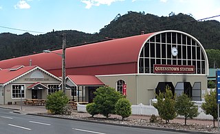
Queenstown in Western Tasmania has had two railway stations. The original was built for the railway built for the Mount Lyell Mining and Railway Company, and lasted until the closing of the railway line in 1962. The newer station was built for the re-built railway, the West Coast Wilderness Railway.
Zeehan Highway is a road between Zeehan and Queenstown in Western Tasmania.
Queenstown to Strahan road is a road that connects Queenstown with Strahan in Western Tasmania.
Driffield Street, Queenstown is the main north to south street of Queenstown, Tasmania, Australia.