Related Research Articles

Mokhotlong is a constituency, city and seat of Mokhotlong District in the mountainous northeastern part of Lesotho. It is the first major city with an airport along the road from South Africa across the Sani Pass, near the Maloti Mountains. The name of the city is a word in Sesotho, the language of the people of Lesotho, meaning "Place of the Bald Ibis." Thabana Ntlenyana, the highest point in southern Africa, is found in Mokhotlong.

The Grossglockner, or just Glockner, is, at 3,798 metres above the Adriatic (12,461 ft), the highest mountain in Austria and the highest mountain in the Alps east of the Brenner Pass. It is part of the larger Glockner Group of the Hohe Tauern range, situated along the main ridge of the Central Eastern Alps and the Alpine divide. The Pasterze, Austria's most extended glacier, lies on the Grossglockner's eastern slope.

U.S. Route 550 (US 550) is a spur of U.S. Highway 50 that runs from Bernalillo, New Mexico to Montrose, Colorado in the western United States. The section from Silverton to Ouray is frequently called the Million Dollar Highway. It is one of the roads on the Trails of the Ancients Byway, one of the designated New Mexico Scenic Byways.

Chimanimani, originally known as Melsetter, is a mountainous district in Manicaland Province of eastern Zimbabwe. The district headquarters is the town of Chimanimani.

Toubkal or Tubkal, also Jbel Toubkal or Jebel Toubkal, is a mountain peak in southwestern Morocco, located in the Toubkal National Park. At 4,167 m (13,671 ft), it is the highest peak in Morocco, the Atlas Mountains, North Africa and the Arab world. Located 63 km (39 mi) south of the city of Marrakesh, and visible from it, Toubkal is an ultra prominent peak, the highest for over 2,000 km (1,200 mi). Toubkal is ranked 27th by topographic isolation.

Mountain running is a sports discipline which takes place mainly off-road in mountainous terrain, but if there is significant elevation gain on the route, surfaced roads may be used. In this it differs from fell running; also its courses are more clearly marked and avoid dangerous sections. It is a form of trail running if it is run on unpaved surfaces. Mountain running is a combination of running, jogging, and walking, depending on how steep the trail is.

The R37 is a provincial route in South Africa that connects Polokwane with Nelspruit (Mbombela) via Burgersfort and Lydenburg.

Huayna Potosí is a mountain in Bolivia, located near El Alto and about 25 km north of La Paz in the Cordillera Real.
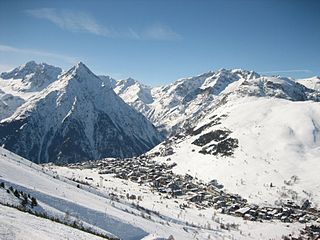
Les 2 Alpes is a ski resort in the French department of Isère, Auvergne-Rhône-Alpes. The village sits at 1,650 m (5,413 ft) and lifts run to 3,600 m (11,811 ft). It has the largest skiable glacier in Europe and is France's second oldest ski resort behind Chamonix. It has the longest, normally open full on-piste vertical available in the world. It is a 71 km (44 mi) drive southeast of Grenoble.

Sani Pass is a mountain pass located in the West of KwaZulu-Natal, South Africa on the road between Himeville, KwaZulu-Natal and Mokhotlong, Lesotho. The pass traverses the Great Escarpment of southern Africa in its highest region, the Drakensberg Mountains, which reach an elevation of over 3,000 meters.

State Highway 118 is a 155.3-mile (249.9 km) state highway in the U.S. state of Texas that runs from Big Bend National Park north to Kent and passes through the towns of Study Butte, Alpine, and Fort Davis. SH 118 is maintained by the Texas Department of Transportation (TxDOT). The road lies entirely within the Trans-Pecos region of Texas. SH 118 is a two-lane road along its length except for a section in Alpine where the route follows the path of U.S. Route 67 and U.S. Route 90. All of the route except for the 2.8-mile (4.5 km) section between Big Bend National Park and Farm to Market Road 170 is included in the Texas Historical Commission's Texas Mountain Trail.

Mafadi is a peak on the border of South Africa and Lesotho. At a height of 3,446.1 metres (11,306 ft), it is the highest mountain in the nation of South Africa, but is lower than Thabana Ntlenyana, the highest peak in Lesotho which is, at 3,482 metres (11,424 ft), the highest point in Southern Africa.

Montara Mountain, positioned between the unincorporated community of Montara, California, to the southwest and the city of Pacifica, California, to the north, forms the northern spur of the Santa Cruz Mountains, a narrow mountain range running the length of the San Francisco Peninsula that separates San Francisco Bay from the Pacific Ocean. Its highest point rises to 1,898 feet (579 m) above sea level. Montara and Pacifica are connected by the Tom Lantos Tunnels, which run through the Mountain.

Nacimiento-Fergusson Road is the only road across the Santa Lucia Range on the Central Coast of California, connecting California State Route 1 and the Big Sur coast to U.S. Route 101 and the Salinas Valley. The road is well-paved and maintained over its length, but is winding and has precipitous drops. It is widely regarded as one of the best motorcycling roads in central California due to its ocean views and forest setting.

Tully Mountain, 1,163 ft (354 m), is a prominent, steep-sided monadnock located in north central Massachusetts in the town of Orange. It is part of the Tully Mountain Wilderness Management Area. An exposed east facing ledge on the summit provides views of the Millers River valley, Mount Monadnock, Mount Wachusett, and the Wapack Range. The 22-mile (35 km) Tully Trail traverses the mountain.

Hay Bluff is a prominent hill at the northern tip of the Black Mountains, an extensive upland massif which straddles the border between south-east Wales and England. The mountain sits at the point where the main northeast-facing escarpment of the Black Mountains meets the northwest facing escarpment, the next peak to the west being Twmpa. The flat summit of Hay Bluff which is marked by a triangulation pillar at a height of 677 metres (2,221 ft) overlooks the middle Wye Valley and the book town of Hay-on-Wye.

The Conejo Grade is a 7% grade incline on a section of US 101. Also known as the Camarillo Grade, it links Thousand Oaks and cities of the Conejo Valley, with Camarillo and the cities on the Oxnard Plain. With a summit elevation of 841.1 feet (256.4 m), California Highway Patrol inspection stations for trucks are situated on both sides of the highway at the upper terminus of the grade.

The R518 is a Regional Route in South Africa that connects Lephalale with Zebediela via Mokopane.
Kloof Nek Road, one of South Africa's oldest roads, was built in 1848 as an access road for the suburban pass with the same name which was used primarily as a look-out post for soldiers and a supply route to Camps Bay. The route starts at Kloof Street on the edge of the city bowl and turns into Camps Bay Road at the end of a mountain pass running between Table Mountain and Lion's Head. Despite being only two kilometers long, it is very steep with an average gradient 1:11. The summit of Kloof Nek Road is a small but complicated intersection that's not clearly visible on approach and often catches motorists unaware. The road's steepness may be a contributor to the regular occurrence of often-fatal accidents on Kloof Nek Road.

Lekgalameetse Provincial Park is a conserved mountain wilderness of 18,718 ha in the northern Drakensberg of Limpopo Province, South Africa. The reserve entrance is 5 km by dirt road from Ofcolaco. Indigenous forest and mixed woodland occupy the valleys, while the mountain crests are covered in grassland. In the north the Park is contiguous with the Wolkberg Wilderness Area.
References
- ↑ Roberts, Trygve. "Orrie Baragwanath Pass - Mountain Passes South Africa". www.mountainpassessouthafrica.co.za. Retrieved 26 March 2023.
24°08′48″S30°12′01″E / 24.14667°S 30.20028°E
| | This Limpopo location article is a stub. You can help Wikipedia by expanding it. |