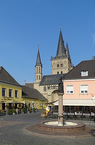
Kleve is a town in the Lower Rhine region of northwestern Germany near the Dutch border and the River Rhine. From the 11th century onwards, Cleves was capital of a county and later a duchy. Today, Cleves is the capital of the district of Kleve in the German state of North Rhine-Westphalia. The city is home to one of the campuses of the Rhine-Waal University of Applied Sciences.

The County of Mark was a county and state of the Holy Roman Empire in the Lower Rhenish–Westphalian Circle. It lay on both sides of the Ruhr River along the Volme and Lenne rivers.
Kleve or Kreis Kleve is a Kreis in the Lower Rhine region of northwestern North Rhine-Westphalia, Germany. Neighbouring districts are Borken, Wesel, and Viersen in Germany, and the Dutch provinces of Limburg and Gelderland.

Neuss is a city in North Rhine-Westphalia, Germany. It is located on the west bank of the Rhine opposite Düsseldorf. Neuss is the largest city within the Rhein-Kreis Neuss district. It is primarily known for its historic Roman sites, as well as the annual Neusser Bürger-Schützenfest. Neuss and Trier share the title of "Germany's oldest city", and in 1984 Neuss celebrated the 2000th anniversary of its founding in 16 BCE.
Xanten is a town in the state of North Rhine-Westphalia, Germany. It is located in the district of Wesel.

The Duchy of Cleves was a State of the Holy Roman Empire which emerged from the medieval Hettergau. It was situated in the northern Rhineland on both sides of the Lower Rhine, around its capital Cleves and the towns of Wesel, Kalkar, Xanten, Emmerich, Rees and Duisburg bordering the lands of the Prince-Bishopric of Münster in the east and the Duchy of Brabant in the west. Its history is closely related to that of its southern neighbours: the Duchies of Jülich and Berg, as well as Guelders and the Westphalian county of Mark. The Duchy was archaically known as Cleveland in English.

Geldern is a city in the federal German state of North Rhine-Westphalia. It is part of the district of Kleve, which is part of the Düsseldorf administrative region. The nearby Dutch province of Gelderland is named after this city.

Weeze is a municipality in the Lower Rhine (Niederrhein) region, located in the northwestern part of North Rhine-Westphalia, specifically in the district of Kleve and the Düsseldorf region.

Rees is a town in the district of Kleve in the state of North Rhine-Westphalia, Germany. It is located on the right bank of the Rhine, approximately 20 km east of Kleve. The population in 2005 was 22,559. Founded in 1228, Rees is the oldest town in the lower Rhine area.

Rheinberg is a town in the district of Wesel, in North Rhine-Westphalia, Germany. It is situated on the left bank of the Rhine, approx. 10 kilometres north of Moers and 15 km south of Wesel.
Zons, formerly known as Feste Zons(Fortress Zons), today officially called Stadt Zons is an old town in Germany on the west bank of the Lower Rhine between Cologne and Düsseldorf. It has been a part (Stadtteil) of the town of Dormagen since 1975. In 2020 its population was 5,452.
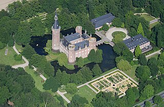
Moyland Castle is a moated castle in Bedburg-Hau in the district of Kleve, one of the most important neo-Gothic buildings in North Rhine-Westphalia. Its name derives from the Dutch word Mooiland which means "beautiful country". The name was probably coined by Dutch workers, whom the then-leaseholder Jacob van den Eger of the Lower Rhine brought to the property in 1307 to drain the surrounding wetlands.

Moers station is located on the Lower Rhine Railway, which was built in 1904 by the Prussian state railways. It lies on the eastern edge of central Moers in the German state of North Rhine-Westphalia on the road to Duisburg-Homberg. The station is now a stop for Regional-Express service RE 44 and Regionalbahn service RB 31. It is classified by Deutsche Bahn as a category 5 station.

The earliest Austrian walled towns started to appear in the late 11th century to the early 13th century. Their establishment was closely connected with the development of Austria as a march of the Holy Roman Empire and in particular by the Hohenstaufen emperors and their Marcher Lords, the Babenbergs. In present-day Austria, there are 106 towns or cities that were walled. The walls of Radstadt, Freiburg, Hainburg and Drosendorf survive almost intact, and Austria has some of the most impressive walled towns in Europe.

The siege of Meurs took place between 29 August to 3 September 1597 during the Eighty Years' War and the Anglo–Spanish War. The Spanish occupied city of Moers under Governor Andrés de Miranda was besieged by Dutch and English troops under the command of Prince Maurice of Orange. The siege ended with the capitulation and the withdrawal of the Spanish garrison. The siege was part of Maurice's campaign of 1597 known as the Ten Glory Years, his highly successful offensive against the Spaniards.

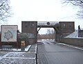
Schenkenschanz is a small community in North Rhine-Westphalia, Germany that was incorporated into the town of Kleve (Cleves) in 1969. Schenkenschanz is site of the former Schenkenschans fortress that was of significance in the Dutch Revolt.

A Landesburg or landesherrliche Burg was a castle that a territorial lord, such as a prince-bishop, duke or prince built for the defence or expansion of his sovereign estates. They were thus the central and most important castles of the great princely territories. The Landesburgen were usually the property of the territorial lord, but they sometimes referred to castles that he did not own, but were available to him as a safe house (Offenhaus). The large castles of the 8th to 10th centuries, east of the Rhine and outside the towns were often described as Landesburgen because they performed important functions in the control of the state.

The County of Moers was a historical princely territory on the left bank of the Lower Rhine that included the towns of Moers and Krefeld as well as the surrounding villages and regions.

The Treaty of Vossem was signed on 6 June 1673, between Frederick William, Elector Brandenburg and Louis XIV of France; England, then a French ally against the Dutch, was included as a party to the terms but not a signatory. It was ratified by both parties on 20 July.

Frederick von Saarwerden was archbishop-elector of Cologne as Frederick III from 1370 to 1414. Through the promotion of his great-uncle, Archbishop Kuno II of Falkenstein of Trier, Frederick von Saarwerden was elected archbishop of Cologne at the age of 20, which the Pope in Avignon also confirmed two years later after some misgivings. Frederick found the archbishopric completely plundered by his two predecessors of the County of Mark, Adolf and Engelbert, and had himself promised high payments to the Curia on the occasion of his election. Nevertheless, with the help of his very rich great-uncle Kuno, he succeeded in paying off the debts of the archbishopric within a few years.