Look up Orwell in Wiktionary, the free dictionary.
Orwell may refer to:
Orwell may refer to:

Suffolk is a ceremonial county of England in East Anglia. It borders Norfolk to the north, Cambridgeshire to the west and Essex to the south; the North Sea lies to the east. The county town is Ipswich; other important towns include Lowestoft, Bury St Edmunds, Newmarket, and Felixstowe which has one of the largest container ports in Europe.

East Anglia is an area in the East of England, often defined as including the counties of Norfolk, Suffolk and Cambridgeshire. The name derives from the Anglo-Saxon kingdom of the East Angles, a people whose name originated in Anglia, in what is now Northern Germany.
Albany, derived from the Gaelic for Scotland, most commonly refers to:
Ipswich is a town and borough in Suffolk, England, of which it is the county town. The town is located in East Anglia about 9.9 mi (16 km) away from the mouth of the River Orwell and the North Sea.
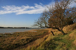
The River Orwell flows through the county of Suffolk in England from Ipswich to Felixstowe. Above Ipswich, the river is known as the River Gipping, but its name changes to the Orwell at Stoke Bridge, where the river becomes tidal. It broadens into an estuary at Ipswich, where the Ipswich dock has operated since the 7th century, and then flows into the North Sea at Felixstowe, the UK's largest container port, after joining the River Stour at Shotley forming Harwich harbour.
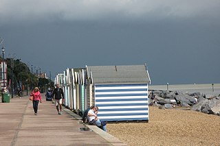
Felixstowe is a port town in Suffolk, England. The estimated population in 2017 was 24,521. The Port of Felixstowe is the largest container port in the United Kingdom. Felixstowe is approximately 72 miles (116 km) northeast of London.

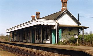
The Felixstowe branch line is a railway branch line in Suffolk, England, that connects the Great Eastern Main Line to Felixstowe and its port.

Orwell railway station was on the Felixstowe Branch Line near the small village of Nacton, Suffolk, England. It was situated between Derby Road and Trimley stations and was opened in 1877 but was closed in 1959 to allow an acceleration of the service to the remaining stations. The former station building is now a private residence near to the modern Seven Hills crematorium.

Walton is a settlement and former civil parish in the East Suffolk district, in the county of Suffolk, England, lying between the rivers Orwell and Deben. It is now part of Felixstowe parish. In 1911 the parish had a population of 4226.

Nacton is a village and civil parish in the East Suffolk district of Suffolk, England. The parish is bounded by the neighbouring parishes of Levington to the east and Bucklesham in the north. It is located between the towns of Ipswich and Felixstowe.
The Seaplane Experimental Station, formerly RNAS Felixstowe, was a British aircraft design unit during the early part of the 20th century.
Felixstowe School is a secondary school and sixth form with academy status, located in Felixstowe, Suffolk, England.
Felixstowe Beach is a disused railway station which served the seafront and southern part of Felixstowe in Suffolk, England. First opened in 1877, the station closed to freight on 5 December 1966 and to passenger traffic on 11 September 1967. The line remains open and sidings to the south of the station connect with railway lines in the Port of Felixstowe.
Vulcan may refer to:
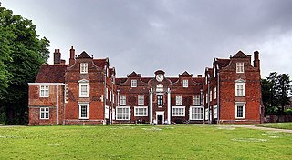
George Tomline, referred to as Colonel Tomline, was an English politician who served as Member of Parliament (MP) for various constituencies. He was the son of William Edward Tomline and grandson of George Pretyman Tomline.
Unity may refer to:

Ipswich is the county town of Suffolk, England. It is a medieval port and industrial town with a strong transport history; the urban area has a population of 122,000 and currently offers urban transport services for cars, cycles and buses. In addition there are 3 railway stations and regional coach services. London Stansted Airport is accessible by the airlink coach.
Felixstowe Pier was a railway station on the Felixstowe Branch Line built in 1877 the site of which is now within the boundary of the Port of Felixstowe. There were a number of sidings that served the docks that were situated to the north of the line as well as one that served the seaplane bases on the south side. The station consisted of a single platform and run round loop. The siding at the "river" end of the run round loop extended onto a jetty.

Newbourne is a village and civil parish in the East Suffolk region of Suffolk, England. It lies on the peninsula between the River Orwell and the River Deben, to the east of Ipswich and south of Woodbridge.
The Shotley Peninsula is a rural area east of the A137 Ipswich-Colchester road located between the rivers Stour and Orwell in Suffolk, England. The peninsula is named after the settlements of Shotley and Shotley Gate which are situated near its south-eastern tip. Other villages on the peninsula include Chelmondiston, Erwarton (Arwarton), Freston, Harkstead, Holbrook, Stutton, Tattingstone, Wherstead and Woolverstone.