Oshakati East

Last updated
Oshakati East constituency (red) in the Oshana Region (yellow) Wahlkreis Oshakati (Ost) (2014).svg
Oshakati East constituency (red) in the Oshana Region (yellow)

Oshakati East is an electoral constituency in the Oshana Region of Namibia. It comprises the eastern parts of the town of Oshakati. The constituency had 22,634 inhabitants in 2004 [1] and 19,606 registered voters in 2020. [2]

Oshakati East was created in 1998. Following a recommendation of the Second Delimitation Commission of Namibia, and in preparation of the 1998 general election, the old Oshakati Constituency was split into Oshakati West and Oshakati East. [3] The Okatana River separates the two constituencies. [4]

Politics

Oshakati is traditionally a stronghold of the South West Africa People's Organization (SWAPO) party. In the 2004 regional election SWAPO candidate Lotto Kuushomwa received 6,697 of the 7,324 votes cast. [5] Kuushomwa was reelected in the 2010 regional elections with 6,501 votes. He defeated challengers Epafras Nghinamundova of the Rally for Democracy and Progress (RDP, 276 votes), Agatus Antanga of the Democratic Turnhalle Alliance (DTA, 72 votes), Timoteus Kambishi of the Congress of Democrats (CoD, 34 votes) and Ndateelela Nakale of SWANU (16 votes). [6] Councillor Kuushomwa (SWAPO) was again reelected in the 2015 regional elections. He won with 5,559 votes, far ahead of Daniel Andreas (DTA) with 241 votes and Natangwe Shiwayu (RDP) with 81 votes. [7]

The SWAPO candidate also won the 2020 regional election, albeit by a much smaller margin. Abner Shikongo obtained 4,575 votes, followed by Simon Neshiko of the Independent Patriots for Change (IPC), an opposition party formed in August 2020, with 2,411 votes. [2]

Related Research Articles

<span class="mw-page-title-main">Linyanti Constituency</span> Electoral constituency in Namibia

Linyanti Constituency is a constituency located in Namibia's Zambezi Region, and has a population of 10,425 residents as of 2023.

<span class="mw-page-title-main">Sibbinda Constituency</span> Electoral constituency in Namibia

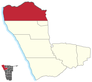
Sibbinda Constituency is a constituency in Namibia's Zambezi Region, with its administrative centre located in the settlement of Sibbinda. As of 2023, it has a population of 17,126 residents.

<span class="mw-page-title-main">Katima Mulilo Urban</span> Electoral constituency in Zambezi region, Namibia

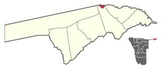
Katima Mulilo UrbanConstituency is an electoral district in Namibia. It is situated in the Zambezi Region. The region's capital, Katima Mulilo, is in this constituency. The constituency has a population of 28,362 people. In the 2020 Regional Council Elections, there were 13,860 registered voters.

<span class="mw-page-title-main">Katima Mulilo Rural</span> Electoral constituency in Zambezi region, Namibia

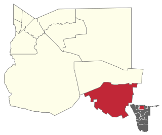
Katima Mulilo Rural is a constituency in the Zambezi Region of Namibia. It comprises the area south of the town of Katima Mulilo, the regional capital. As of 2020, the constituency had 6,712 registered voters.

<span class="mw-page-title-main">Windhoek East</span> Electoral constituency in the Khomas region of central Namibia

Windhoek East is a constituency in the Khomas Region of Namibia. It consists of the upper-class suburbs of Windhoek: Auasblick, Avis, Klein Windhoek, Ludwigsdorf, Luxury Hill, Olympia, and Suiderhof. It had a population of 22,712 in 2011, up from 17,674 in 2001. As of 2020, it has 17,308 registered voters.

<span class="mw-page-title-main">Epupa Constituency</span> Electoral constituency in the Kunene region of north-western Namibia

Epupa Constituency is a constituency in the Kunene Region of Namibia. The constituency contains the Epupa Falls after which it is named, located on the Angolan-Namibian border. Its population in 2004 was 12,816. In 2020 it had 12,182 registered voters.

<span class="mw-page-title-main">Rehoboth Rural</span> Electoral constituency in Hardap region, Namibia

Rehoboth Rural is an electoral constituency in the Hardap region of Namibia. It had a population of 7,288 in 2011, down from 7,524 in 2001. The constituency office is in Schlip. Other settlements in Rehoboth Rural are Klein Aub, Khauxas and Rietoog. As of 2020, the constituency had 4,701 registered voters.

<span class="mw-page-title-main">Rehoboth Urban East</span> Electoral constituency in Namibia

Rehoboth Urban East is an electoral constituency in the Hardap region of Namibia, comprising the suburbs of Rehoboth that are situated to the east of the national road B1. It had a population of 18,035 in 2011, up from 12,891 in 2001. As of 2020 the constituency had 12,112 registered voters.

<span class="mw-page-title-main">Kalahari Constituency</span> Electoral constituency in the Omaheke region of eastern Namibia

Kalahari Constituency is an electoral constituency in the Omaheke Region of eastern central Namibia. It had 9,234 inhabitants in 2004 and 5,294 registered voters in 2020. The constituency covers the rural area east of Gobabis as well as Gobabis' Nossobville suburb. The constituency office has been inaugurated in 2009 and is located at the Ben-Hur settlement. Kalahari constituency forms part of the border between Namibia and Botswana.

<span class="mw-page-title-main">Ohangwena Constituency</span> Electoral constituency in the Ohangwena region of northern Namibia

Ohangwena is a constituency in the Ohangwena Region of northern Namibia. It had 17,539 inhabitants in 2004 and 13,181 registered voters in 2020. It is named after the settlement of Ohangwena, today part of the town Helao Nafidi.

<span class="mw-page-title-main">Omundaungilo Constituency</span> Electoral constituency in the Ohangwena region of northern Namibia

Omundaungilo is an electoral constituency in the Ohangwena Region of Namibia, on the border to Angola. It has 8,085 inhabitants in 2004 and 6,642 registered voters in 2020.

<span class="mw-page-title-main">Ongenga Constituency</span> Electoral constituency in the Ohangwena region of northern Namibia

Ongenga is a constituency in the Ohangwena Region of Namibia, on the border to Angola. It had 21,474 in 2004 and 12,682 registered voters in 2020.

<span class="mw-page-title-main">Ruacana Constituency</span> Electoral constituency in the Omusati region of northern Namibia

Ruacana Constituency is an electoral constituency in the Omusati Region of Namibia on the border to Angola. It had 10,722 inhabitants in 2004 and 9,285 registered voters in 2020. Its district capital is the town of Ruacana.

<span class="mw-page-title-main">Ongwediva Constituency</span> Electoral constituency in the Oshana region of northern Namibia

Ongwediva Constituency is an electoral constituency in the Oshana Region of Namibia. It had 27,396 inhabitants and 22,061 registered voters in 2020. Its district capital is the town of Ongwediva.

<span class="mw-page-title-main">Oshakati West</span> Electoral constituency in the Oshana region of northern Namibia

Oshakati West is an electoral constituency in the Oshana Region of Namibia. It contains the western parts of the town of Oshakati. The constituency had 20,015 inhabitants in 2004 and 15,120 registered voters in 2020.

<span class="mw-page-title-main">Windhoek West Constituency</span> Electoral constituency in Windhoek, Namibia

Windhoek West Constituency is an electoral constituency in the Khomas Region of Namibia. It contains the affluent suburbs of Hochland Park, Pioneers Park, Academia, Cimbebasia, Rocky Crest, Windhoek North and Windhoek West. It had a population of 53,438 in 2011, up from 42,201 in 2001. As of 2020, it has 33,556 registered voters.

<span class="mw-page-title-main">Swakopmund Constituency</span> Electoral constituency in Erongo region, Namibia

Swakopmund constituency is a constituency in the Erongo Region of Namibia. The constituency had a population of 44,725 in 2011, up from 26,310 in 2001. The coverage of the constituency and its district capital is the city of Swakopmund. As of 2020 the constituency had 35,668 registered voters.

<span class="mw-page-title-main">Walvis Bay Urban</span> Electoral constituency in the Erongo region of eastern central Namibia

Walvis Bay Urban is a constituency in the Erongo Region of Namibia, comprising most of the city of Walvis Bay. It had a population of 35,828 in 2011, up from 27,941 in 2001. As of 2020 the constituency had 25,311 registered voters.

<span class="mw-page-title-main">Rundu Urban</span> Electoral constituency in the Kavango East region of north-eastern Namibia

Rundu Urban is an electoral constituency in the Kavango East region of Namibia. It covers the urban area of Rundu, the region's capital and one of Namibia's largest cities. The constituency also covers parts of the Sauyemwa, Safari, Tutungeni, Katutura, Donkerhoek and Kehemu neighborhoods. It had a population of 20,953 in 2011, up from 19,173 in 2001. As of 2020 the constituency had 35,740 registered voters.

<span class="mw-page-title-main">Tsumeb Constituency</span> Electoral constituency in the Oshikoto region of northern Namibia

Tsumeb Constituency is an electoral constituency in the Oshikoto Region of Namibia, comprising the town area and surroundings of Tsumeb. It had a population of 44,113 in 2004 and 19,065 registered voters in 2020.

References

  1. Constituencies of Namibia, 2004
  2. 1 2 "Regional Council 2020 Election Results". Interactive map. Electoral Commission of Namibia. 18 January 2021. Retrieved 10 November 2021.
  3. "Re-division of certain regions into constituencies: Regional Councils Act, 1992" (pdf). Government Gazette of the Republic of Namibia. No. 1940. Government of Namibia. 31 August 1998. pp. 12–13.
  4. Kadhikwa, Pendapawa (13 September 2011). "Oshakati to deepen river". The Namibian . p. 1. Archived from the original on 3 June 2012.
  5. "Electoral Act, 1992: Notification of Result of General Election for Regional Councils" (pdf). Government Gazette of the Republic of Namibia. No. 3366. Government of Namibia. 3 January 2005. p. 7.
  6. Election results from Electoral Commission of Namibia
  7. "Regional Council Election Results 2015". Electoral Commission of Namibia. 3 December 2015. p. 2. Archived from the original on 8 December 2015. Retrieved 19 December 2015.

17°47′S15°41′E / 17.783°S 15.683°E / -17.783; 15.683