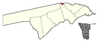
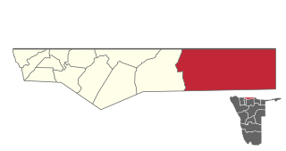
Katima Mulilo UrbanConstituency is an electoral district in Namibia. It is situated in the Zambezi Region. The region's capital, Katima Mulilo, is in this constituency. The constituency has a population of 28,362 people. In the 2020 Regional Council Elections, there were 13,860 registered voters.

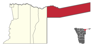
Katima Mulilo Rural is a constituency in the Zambezi Region of Namibia. It comprises the area south of the town of Katima Mulilo, the regional capital. As of 2020, the constituency had 6,712 registered voters.

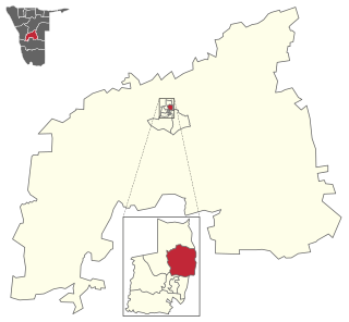
Rehoboth Urban West is an electoral constituency in the Hardap region of Namibia, comprising the suburbs of Rehoboth that are situated to the west of the national road B1. It had a population of 11,197 in 2011, up from 9,238 in 2001. As of 2020 the constituency had 8,324 registered voters.

Omaruru is a constituency in the Erongo Region of central-eastern Namibia. Its district capital is the city of Omaruru. It had a population of 8,577 in 2011, up from 7,156 in 2001. As of 2020 the constituency had 6,672 registered voters.
Tobias Hainyeko constituency is an electoral constituency in Windhoek, the capital of Namibia. It had a population of 45,912 in 2011, up from 34,348 in 2001. As of 2020 it had 36,530 registered voters.

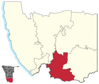
Kalahari Constituency is an electoral constituency in the Omaheke Region of eastern central Namibia. It had 9,234 inhabitants in 2004 and 5,294 registered voters in 2020. The constituency covers the rural area east of Gobabis as well as Gobabis' Nossobville suburb. The constituency office has been inaugurated in 2009 and is located at the Ben-Hur settlement. Kalahari constituency forms part of the border between Namibia and Botswana.
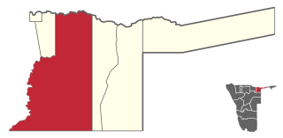
Mukwe is a constituency in the Kavango East region of Namibia. The district centre is the settlement of Mukwe. It had a population of 27,690 in 2011, up from 27,250 in 2001. The constituency contains the major settlements of Bagani, Kangongo and Divundu, and a number of small populated places such as Andara and Diyogha. As of 2020 the constituency had 16,678 registered voters.
Mashare is a constituency in the Kavango East region of northern Namibia. The district centre is the settlement of Mashare. It had a population of 15,688 in 2011, down from 16,007 in 2001. As of 2020 the constituency had 9,165 registered voters.
Okongo is a constituency in the Ohangwena Region of Namibia, on the border to Angola. It had about 18,000 inhabitants in 2011 and 12,562 registered voters in 2020.

Ruacana Constituency is an electoral constituency in the Omusati Region of Namibia on the border to Angola. It had 10,722 inhabitants in 2004 and 9,285 registered voters in 2020. Its district capital is the town of Ruacana.

Okatyali Constituency is an electoral constituency in the Oshana Region of Namibia. It had 2,815 inhabitants in 2004 and 2,051 registered voters in 2020. Its district capital is the settlement of Okatyali.

Oshakati East is an electoral constituency in the Oshana Region of Namibia. It comprises the eastern parts of the town of Oshakati. The constituency had 22,634 inhabitants in 2004 and 19,606 registered voters in 2020.

Grootfontein Constituency is an electoral constituency in the Otjozondjupa Region of Namibia. It had 21,595 inhabitants in 2004 and 16,629 registered voters in 2020. The constituency consists of the town of Grootfontein and the surrounding rural area. Until 1998 it also contained the area that today is Tsumkwe Constituency. It was split off following a recommendation of the Second Delimitation Commission of Namibia, and in preparation of the 1998 general election.

Okahandja Constituency is an electoral constituency in the Otjozondjupa Region of Namibia. It had 18,155 inhabitants in 2004 and 18,109 registered voters in 2020. The constituency consists of the town of Okahandja and the surrounding rural area.

Otjiwarongo Constituency is an electoral constituency in the Otjozondjupa Region of Namibia. It had 22,614 inhabitants in 2004 and 22,931 registered voters in 2020. The constituency consists of the town of Otjiwarongo and the surrounding rural area.

Tsumkwe Constituency is an electoral constituency in the Otjozondjupa Region of Namibia. It had 8,823 inhabitants in 2004 and 7,075 registered voters in 2020. About 2,400 San people live in this constituency. The constituency consists of the settlement of Tsumkwe and the surrounding rural area.

Windhoek West Constituency is an electoral constituency in the Khomas Region of Namibia. It contains the affluent suburbs of Hochland Park, Pioneers Park, Academia, Cimbebasia, Rocky Crest, Windhoek North and Windhoek West. It had a population of 53,438 in 2011, up from 42,201 in 2001. As of 2020, it has 33,556 registered voters.

Moses ǁGaroëb Constituency is an electoral constituency in Windhoek, the capital of Namibia. It had a population of 45,564 in 2011, up from 25,642 in 2001. As of 2020 it had 41,550 registered voters.
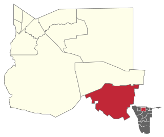
Karasburg West is an electoral constituency in the ǁKaras Region of Namibia. As of 2020 the constituency had 6,609 registered voters.
Tsumeb Constituency is an electoral constituency in the Oshikoto Region of Namibia, comprising the town area and surroundings of Tsumeb. It had a population of 44,113 in 2004 and 19,065 registered voters in 2020.
