Bytown is the former name of Ottawa, Ontario, Canada. It was founded on September 26, 1826, incorporated as a town on January 1, 1850, and superseded by the incorporation of the City of Ottawa on January 1, 1855. The founding was marked by a sod turning, and a letter from Governor General Dalhousie which authorized Lieutenant Colonel John By to divide up the town into lots. Bytown came about as a result of the construction of the Rideau Canal and grew largely due to the Ottawa River timber trade. Bytown's first mayor was John Scott, elected in 1847.
Guildwood, also known as Guildwood Village, is a residential neighbourhood in Toronto, Ontario, Canada. It is located in the eastern area of the city, in the district of Scarborough. It is bounded by the Scarborough Bluffs, south of Kingston Road, from Grey Abbey Trail in the east.

West Hill is a neighbourhood in Toronto, Ontario, Canada. It is located in the eastern end of the city, in the former suburb of Scarborough. It is roughly bounded by Scarborough Golf Club Road and a branch of Highland Creek on the west, the CNR railway tracks and Lake Ontario on the south, and Highland Creek on the north-east. The name comes from its elevated position on the west side of Highland Creek, a deep glacial ravine.

New Fort York, later the Stanley Barracks, is a former British and Canadian military base in Toronto, Ontario, Canada, located on the Lake Ontario shoreline. It was built in 1840–1841 to replace Toronto's original Fort York at the mouth of Garrison Creek as the primary military base for the settlement. Unlike the older fort, many of the new fort buildings were made with limestone instead of wood. A protective wall was planned for the new fort but was never built. The fort was used by the British army until 1870, and the Canadian military subsequently used the fort to train troops for the Second Boer War, World War I and World War II. It also trained one of the first regiments of the North-West Mounted Police. The Canadian military stopped using it after World War II and the fort was demolished in the 1950s. Only the Officers' Quarters building remains on the site.

Clarkson, also called Clarkson Village, is a neighbourhood in the city of Mississauga, Ontario, Canada, situated in the southwest corner of the city, along the shore of Lake Ontario. It is bordered by Lake Ontario to the south, Oakville to the west, Erindale and Erin Mills to the north, and Lorne Park to the east.

The Scarborough Bluffs, also known as The Bluffs, is an escarpment in the Scarborough district of Toronto, Ontario, Canada. There are nine parks along the bluffs, with Bluffers Park being the only one with a beach. Forming much of the eastern portion of Toronto's waterfront, the Scarborough Bluffs stands above the shoreline of Lake Ontario. At its highest point, the escarpment rises 90 metres (300 ft) above the coastline and spans a length of 15 kilometres (9.3 mi).

Montgomery's Inn is a historic building located in the Etobicoke area of Toronto, Ontario. Originally constructed as an inn, it now serves as a living history museum and is owned by the City of Toronto.

The Golden Mile is a commercial district in the Scarborough district of Toronto, Ontario, Canada. Situated along Eglinton Avenue East, east of Victoria Park Avenue, it was one of Canada's first model industrial parks. The original Golden Mile of Industry ran along Eglinton from Pharmacy Avenue east to Birchmount Road.

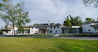
The Guild Inn, or simply The Guild was a historic hotel in the Guildwood neighbourhood of Scarborough, Toronto, Ontario and was once an artists colony. The surrounding Guild Park and Gardens is notable for a sculpture garden consisting of the rescued facades and ruins of various demolished downtown Toronto buildings such as bank buildings, the old Toronto Star building and the Granite Club. The park is situated on the Scarborough Bluffs with views of Lake Ontario. Guild Park remained open and the refurbishment of the Guild Inn into a facility for social events was completed in May 2017.

John Scadding was an early settler in York, Upper Canada. He is remembered for constructing the Scadding Cabin, which is now the oldest surviving building in Toronto. He served as a clerk to John Graves Simcoe, the first Lieutenant Governor of Upper Canada.
Cedar Grove is a community in Markham, Ontario on the Little Rouge River. It is centred on 14th Avenue and Reesor Road and within the boundaries of the future national Rouge Park.

The Ashbridge Estate is a historic estate in eastern Toronto, Ontario, Canada. The property was settled by the Ashbridge family, who were English Quakers who left Pennsylvania after the American Revolutionary War. In 1796, as United Empire Loyalists, the family were granted 600 acres (240 ha) of land on Lake Ontario east of the Don River, land which they had begun clearing two years earlier.

The dogtrot, also known as a breezeway house, dog-run, or possum-trot, is a style of house that was common throughout the Southeastern United States during the 19th and early 20th centuries. Some theories place its origins in the southern Appalachian Mountains. Some scholars believe the style developed in the post-Revolution frontiers of Kentucky and Tennessee. Others note its presence in the South Carolina Lowcountry from an early period. The main style point was a large breezeway through the center of the house to cool occupants in the hot southern climate.

John Cox Cottage, at 469 Broadview Avenue, Toronto, Ontario, Canada, is the oldest known house in the city still used as a residence, and it still resides on its original site. The property, immediately to the east of what was John Scadding's original lot, was deeded to John Cox by Governor Simcoe in 1796.
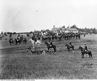
The Toronto Hunt Club was established in 1843 as a fox hunting club by British Army officers of the Toronto garrison. It held gymkhana equestrian events at various sites around Toronto. In 1895, it acquired its first permanent home in a rural area east of the city in Scarborough, between Kingston Road and Lake Ontario.

The Paul Bishop's House is actually a pair of historic townhouses located at 363-365 Adelaide Street East in the St. Lawrence neighborhood downtown Toronto, Ontario, Canada. The houses, constructed in 1848 by Paul Bishop, sit upon the foundations laid by William Jarvis for his home in 1798. Jarvis was a member of the Queen's Rifles and Provincial Secretary and Registrar of Upper Canada. He selected a site at what is now the southeast corner of Sherbourne and Adelaide Streets and constructed a 30 by 41 foot building of squared logs that he covered with clapboards which he named Jarvis House.

The Middletown Historic District is a national historic district located in Middletown, Virginia. It originally encompassed 234 contributing properties, the majority of which are residential buildings and their associated outbuildings. The boundaries of the historic district are approximately Church Street, Senseney Avenue, and First through Sixth Streets, except for a portion of Main Street that ends just south of Reliance Road.

Berkeley House was a prominent house in York, Upper Canada. It was the home of two Clerks of Upper Canada's Privy Council – John Small, and his son Charles Coxwell Small. Upper Canada's first small Parliament buildings were built next door to Berkeley House. Small is reported to have hosted meetings of the province's executive committee in his home.

Guild Park and Gardens is a public park in the Scarborough district of Toronto, Ontario, Canada. The park was formerly the site of an artist colony and is notable for its collection of relics saved from the demolition of buildings primarily in downtown Toronto arranged akin to ancient ruins. Located on the Scarborough Bluffs, Guild Park and Gardens has an outdoor Greek stage and a 19th-century log cabin among the oldest in Toronto. The principal building in the park is the Guild Inn, a former inn and estate mansion.

