
Wulingyuan is a scenic and historical site in the Wulingyuan District of south-central China's Hunan Province. It was inscribed as a UNESCO World Heritage Site in 1992. It is noted for more than 3,000 quartzite sandstone pillars and peaks across most of the site, many over 200 metres (660 ft) in height, along with many ravines and gorges with attractive streams, pools, lakes, rivers and waterfalls. It features 40 caves, many with large calcite deposits, and a natural bridge named Tianqiashengkong, which is one of the highest natural bridges in the world.
Oldřišov is a village in the Moravian-Silesian Region of the Czech Republic. It is part of micro-region Hlučínsko. It has around 1,300 inhabitants.

Jezbořice is a village in the Pardubice Region of the Czech Republic. It has around 320 inhabitants.
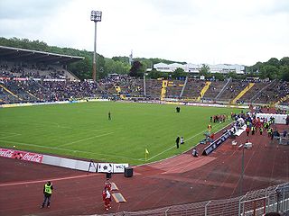
Ludwigsparkstadion is a multi-purpose stadium in Saarbrücken, Germany. It was built in 1953 and holds 35,303 people. After renovation from 2016 to 2017 which costs about € 16 million, the capacity is reduced to around 16,000 seats.
Myalyeshkavichy is a village in Gomel Region in Belarus. It is located 16 kilometres (10 mi) south west of Mazyr.
Bahr is a hamlet in the Dutch province of Gelderland. It is located in the municipality Zevenaar, about 3 km southeast of Rheden.

Bród Kamienny is a village in the administrative district of Gmina Rojewo, within Inowrocław County, Kuyavian-Pomeranian Voivodeship, in north-central Poland. It lies approximately 12 kilometres (7 mi) north-east of Rojewo, 23 km (14 mi) north of Inowrocław, 18 km (11 mi) west of Toruń, and 29 km (18 mi) south-east of Bydgoszcz.

Oglodak Island is an island in the U.S. State of Alaska. It is located in the Aleutians West Census Area, which encompasses most of the Aleutian Island chain. The island is currently uninhabited and has an area of roughly one and a half square mile. The island is 1.19 miles (1.92 km) long and 2.3 miles (3.7 km) wide.
Stoczek is a settlement in the administrative district of Gmina Knyszyn, within Mońki County, Podlaskie Voivodeship, in north-eastern Poland.
Nowe Sójki is a village in the administrative district of Gmina Kutno, within Kutno County, Łódź Voivodeship, in central Poland. It lies approximately 5 kilometres (3 mi) north-east of Kutno and 54 km (34 mi) north of the regional capital Łódź.

Margina is a commune in Timiș County, Romania. It is composed of nine villages: Breazova (Béganyiresd), Bulza (Bulza), Coșevița (Kiskossó), Coșteiu de Sus (Felsőkastély), Groși (Marosgórós), Margina, Nemeșești (Nemcse), Sintești (Bégaszentes) and Zorani (Zorány).
Dęba is a village in the administrative district of Gmina Poświętne, within Opoczno County, Łódź Voivodeship, in central Poland. It lies approximately 10 kilometres (6 mi) south-west of Poświętne, 10 km (6 mi) north of Opoczno, and 66 km (41 mi) south-east of the regional capital Łódź.
Kupientyn-Kolonia is a village in the administrative district of Gmina Sabnie, within Sokołów County, Masovian Voivodeship, in east-central Poland.
Wola Lipieniecka Duża is a village in the administrative district of Gmina Jastrząb, within Szydłowiec County, Masovian Voivodeship, in east-central Poland.
Henrykowo is a settlement in the administrative district of Gmina Kętrzyn, within Kętrzyn County, Warmian-Masurian Voivodeship, in northern Poland.
Żabiniec is a settlement in the administrative district of Gmina Białogard, within Białogard County, West Pomeranian Voivodeship, in north-western Poland. It lies approximately 4 kilometres (2 mi) south-west of Białogard and 110 km (68 mi) north-east of the regional capital Szczecin.
Łatno is a village in the administrative district of Gmina Brojce, within Gryfice County, West Pomeranian Voivodeship, in north-western Poland. It lies approximately 4 kilometres (2 mi) north of Brojce, 14 km (9 mi) north-east of Gryfice, and 82 km (51 mi) north-east of the regional capital Szczecin.
Taylor Pass is a mountain pass in the Chilcotin Ranges of the Coast Mountains of British Columbia, Canada, located at the divide between the headwaters of the Taseko River and those of Gun Creek, a tributary of the Bridge River.

Saarlandhalle is a 5,500-capacity multi-purpose indoor arena located in Saarbrücken, Germany. Originally opened in 1967 with funds from Saarland Sporttoto for sports competitions, it was later converted to multi-purpose indoor arena. The Ludwigsparkstadion is located near the hall. Saarlandhalle is also the first indoor arena in (West) Germany to be organized as a limited liability company.
Throwley Priory was an English priory south of Faversham in Kent.


