Related Research Articles

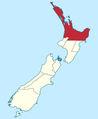
The Northland Region is the northernmost of New Zealand's 16 local government regions. New Zealanders sometimes refer to it as the Winterless North because of its mild climate all throughout the year. The main population centre is the city of Whangārei, and the largest town is Kerikeri. At the 2018 New Zealand census, Northland recorded a population growth spurt of 18.1% since the previous 2013 census, placing it as the fastest growing region in New Zealand, ahead of other strong growth regions such as the Bay of Plenty and Waikato.

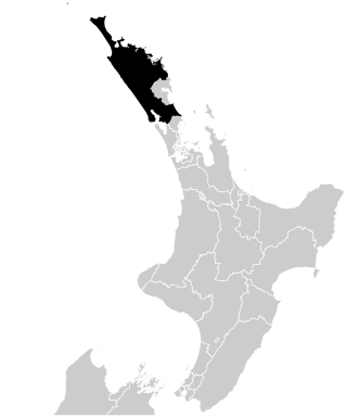
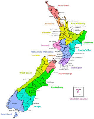
The Kaipara District is located in the Northland Region in northern New Zealand.

A system of counties of New Zealand was instituted after the country dissolved its provinces in 1876, and these counties were similar to other countries' systems, lasting with little change until 1989, when they were reorganised into district and city councils within a system of larger regions.

Ngāti Whātua is a Māori iwi (tribe) of the lower Northland Peninsula of New Zealand's North Island. It comprises a confederation of four hapū (subtribes) interconnected both by ancestry and by association over time: Te Uri-o-Hau, Te Roroa, Te Taoū, and Ngāti Whātua-o-Ōrākei. The four hapū can act together or separately as independent tribes.
Helensville is a town in the North Island of New Zealand. It is sited 40 kilometres (25 mi) northwest of Auckland, close to the southern extremity of the Kaipara Harbour. State Highway 16 passes through the town, connecting it to Waimauku 16 kilometres (10 mi) to the south, and Kaukapakapa about 12 kilometres (7.5 mi) to the north-east. Parakai is two kilometres (1.2 mi) to the north-west.

The North Auckland Line is a major section of New Zealand's national rail network, and is made up of the following parts: the portion of track that runs northward from Westfield Junction to Newmarket Station; from there, westward to Waitakere; from there, northward to Otiria via Whangārei. The first section was opened in 1868 and the line was completed in 1925. The line, or sections of it, have been known at various times as the Kaipara Line, the Waikato-Kaipara Line, the Kaipara Branch and the North Auckland Main Trunk.
The Auckland Province was a province of New Zealand from 1853 until the abolition of provincial government in 1876.
The Northland Rugby Union is the governing body for rugby union in Northland, New Zealand; Northland is a region of New Zealand that covers areas in the districts of Far North, Kaipara, and Whangārei. Established in 1920, they represent the Bunnings NPC side, Northland Taniwha, and Farah Palmer Cup side, Northland Kauri. It is also affiliated with the Blues Super Rugby franchise. Their home playing colours are sky blue and they play their home games at Semenoff Stadium in Morningside.

Rodney is a local government area in the northernmost part of New Zealand's Auckland Region, governed by the Rodney Local Board and Auckland Council. It currently aligns with the council's Rodney Ward.
Northland is a New Zealand parliamentary electorate, returning one Member of Parliament to the New Zealand House of Representatives. The electorate was established for the 1996 election. It was represented by National Party MP John Carter from 1996 to 2011, and then National's Mike Sabin until his resignation on 30 January 2015. The by-election in March 2015 was won by New Zealand First party leader Winston Peters. Peters was defeated by National's Matt King in the 2017 general election. King in turn was defeated by the Labour Party's Willow-Jean Prime in the 2020 general election, who became the first Labour MP elected for the area since the party won the predecessor electorate Bay of Islands in 1938.
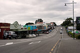
Kaiwaka "the little town of lights" is a settlement in Northland, New Zealand. The Kaiwaka River runs from the east through the area and joins with the Wairau River to form the Otamatea River, which drains into the Kaipara Harbour. State Highway 1 passes through Kaiwaka. Wellsford is 20 km south, Brynderwyn is 8 km north and Whangarei the closest city, being 60 km north. The Mangawhai Heads are 18 km north east.

Te Uri-o-Hau is a Māori iwi (tribe) based around New Zealand's Kaipara Harbour. It is both an independent iwi and a hapū (sub-tribe) of the larger Ngāti Whātua iwi, alongside Ngāti Whātua-o-Ōrākei, Te Roroa and Te Taoū. Its rohe includes Dargaville, Maungaturoto, Mangawhai, Kaiwaka and Wellsford.
Hobson is a former New Zealand parliamentary electorate. It existed from 1946 to 1978 and then from 1987 to 1996, and was represented by five Members of Parliament, four of whom represented the National Party. It is notable for returning a member of the Social Credit Party in the 1966 election, as no other candidate not aligned with either Labour or National had been elected to Parliament since 1943. With the re-drawing of boundaries in the first MMP election in 1996, the seat was absorbed into the Northland and Whangarei electorates.
Kaipara is a former New Zealand parliamentary electorate north of Auckland that existed from 1902 to 1946, and from 1978 to 1996.
A district in New Zealand is a territorial authority area governed by a district council as a second-tier of local government in New Zealand, below regional councils. They were formed as a result of the local government reforms in 1989. There are 53 districts in New Zealand, and they do not include the 12 city councils, the Auckland Council, and the Chatham Islands Council. District councils serve a combination of rural and urban communities, while city councils administer the larger urban areas. Three districts are unitary authorities also performing the functions of a regional council.
Christchurch South was a parliamentary electorate in the city of Christchurch, New Zealand from 1881 to 1890 and then from 1905 to 1946.
The Brynderwyn Range or Brynderwyn Hills is a ridge extending east–west across the Northland Peninsula in northern New Zealand some 60 kilometres south of Whangārei, from the southern end of Bream Bay in the east to the Otamatea River in the west. Though not of great height it is a notable feature of the Northland Region's geography, not least because it is traversed by State Highway 1, which is forced to follow a tortuous route for some distance as it descends to the south. The small settlement of Brynderwyn lies at the southern foot of the hills, at the junction of SH1 and SH12. There are different walks of up to 10 km giving views of the Whangārei Heads, Bream Bay and out to sea.
Hobson County was one of the counties of New Zealand in the North Island, from 1876 until 1989. It came into existence in November 1876, when the provinces were abolished. The county seat was at Aratapu, on the western bank of the Wairoa River, 9.5 kilometres (5.9 mi) south of Dargaville, until 1909, when it moved to Dargaville. In 1908, the town of Dargaville and neighboroughing Mangawhare split from Hobson County to form Dargaville Borough. In the 1989 local government reforms, Hobson County re-amalgamated with Dargaville Borough and merged with Otamatea County and parts of Rodney County and Whangarei County to create Kaipara District.

Portages in New Zealand, known in Māori as Tō or Tōanga Waka, are locations where waka (canoes) could easily be transported overland. Portages were extremely important for early Māori, especially along the narrow Tāmaki isthmus of modern-day Auckland, as they served as crucial transportation and trade links between the east and west coasts. Portages can be found across New Zealand, especially in the narrow Northland and Auckland regions, and the rivers of the Waikato Region.
References
- ↑ "Counties Act 1886" . Retrieved 15 March 2022.
- ↑ "Management implementation of memorandum understanding between Kaipara District Council and Te Uri O Hau, Ngati Whatua". Kaipara District Council. Archived from the original on 14 October 2008.
| | This Northland Region-related geography article is a stub. You can help Wikipedia by expanding it. |