
The Sangha River, a tributary of the Congo River, is located in Central Africa.

Since 10 December 2020, The Central African Republic is administratively divided into 20 prefectures and the capital city of Bangui, which is an autonomous commune.
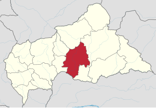
Ouaka is one of the 16 prefectures of the Central African Republic. It borders the Democratic Republic of the Congo, covers an area of 49,900 km2, and has a population of 224,076, giving a population density of under 5 inhabitants/km2. The capital is Bambari.
The Chari River, or Shari River, is a 1,400 kilometres (870 mi) long river, flowing in Central Africa. It is Lake Chad's main source of water.
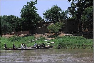
Bambari is a town in the Central African Republic, lying on the Ouaka River. It has a population of 41,356 and is the capital of Ouaka prefecture. Bambari is an important market town and is home to Bambari Airport, and the Roman Catholic Diocese of Bambari.
Ippy is a town located in the Central African Republic prefecture of Ouaka, and is located near the geographic center of the country. It is 364 kilometers from the city of Bangui directly. Driving distance, however, is 496 kilometers.
Kouango is a town located in the Central African Republic prefecture of Ouaka.

Tovuz is a city and the capital of the Tovuz District of Azerbaijan. It's famous for its wine-making, and it also has several archaeological sites. Tovuz region was established on August 8, 1930. The district is one of the largest agricultural districts in the country, its area is 1942 sq. km, and its population is 177.2 thousand people as of 01.01.2020.
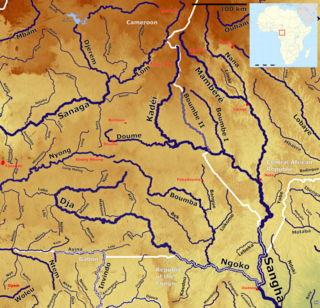
The Kadéï River is a tributary of the Sangha River that flows through Cameroon and the Central African Republic. Its total drainage basin is 24,000 km2. The river rises from the eastern Adamawa Plateau, southeast of Garoua-Boulaï in Cameroon's East Province. The Kadéï is swelled by two tributaries, the Doumé at Mindourou and the Boumbé, before flowing east into the Central African Republic. At Nola, the Kadéï meets the Mambéré and becomes the Sangha. The Kadéï is part of the Congo River basin.
Bambari Airport is an airport serving Bambari, a city in the Ouaka prefecture of the Central African Republic.

The Roman Catholic Diocese of Bambari is a suffragan Latin Rite diocese in Bambari in the Ecclesiastical province of Bangui, which covers the Central African Republic, yet depends on the missionary Roman Congregation for the Evangelization of Peoples.
Grimari is a city located in the Ouaka prefecture in Central African Republic, approximately 222.7 kilometres (138.4 mi) away from the capital, Bangui. The politician Abel Goumba was born in Grimari.

Bakala is a sub-prefecture and town in the Ouaka Prefecture of the southern-central Central African Republic. It is located near the geographic center of the country.
The Central African Republic is divided into 20 prefectures and one autonomous commune. The prefectures (préfectures) are further divided into 84 sub-prefectures (sous-préfectures).

Health in the Central African Republic has been degraded by years of internal conflict and economic turmoil since independence from France in 1960. One sixth of the country's population is in need of acute medical care. Endemic diseases put a high demand on the health infrastructure, which requires outside assistance to sustain itself.

The Plain of Vic is a 30 km long depression located at the eastern end of the Catalan Central Depression in the Osona comarca. It is named after the town of Vic, an important and ancient urban center in this natural region that lies in the midst of the plain. Other significant towns in the plain are Manlleu and Tona.
The Mantsa River is a river of southern Ethiopia. It is a south-flowing tributary of the Omo River, entering it on the right bank at 6°42′28″N36°55′52″E.
Honey Creek is a stream in Pottawattamie and Harrison counties, Iowa, in the United States. It is a tributary of Missouri River.
