The Rhine is one of the major European rivers. The river begins in the Swiss canton of Graubünden in the southeastern Swiss Alps. It forms part of the Swiss-Liechtenstein border, then part of the Swiss-Austrian border. From Lake Constance downstream, it forms part of the Swiss-German border. After that the Rhine defines much of the Franco-German border. It then flows in a mostly northerly direction through the German Rhineland. Finally in Germany, the Rhine turns into a predominantly westerly direction and flows into the Netherlands where it eventually empties into the North Sea. It drains an area of 9,973 km2.

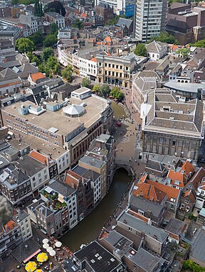
Utrecht is the fourth-largest city of the Netherlands, as well as the capital and the most populous city of the province of Utrecht. The municipality of Utrecht is located in the eastern part of the Randstad conurbation, in the very centre of mainland Netherlands, and includes Haarzuilens, Vleuten and De Meern. It has a population of 361,699 as of December 2021.

Alphen aan den Rijn is a city and municipality in the western Netherlands, in the province of South Holland. The city is situated on the banks of the river Oude Rijn, where the river Gouwe branches off. The municipality had a population of 112,587 in 2021, and covers an area of 132.50 km2 (51.16 sq mi) of which 6.27 km2 (2.42 sq mi) is water.

The Lek is a river in the western Netherlands of some 60 km (37 mi) in length. It is the continuation of the Nederrijn after the Kromme Rijn branches off at the town of Wijk bij Duurstede. The main westbound waterway is hereafter called the Lek River. The Nederrijn is, itself, a distributary branch of the river Rhine.

Castlefield is an inner-city conservation area in Manchester, North West England. The conservation area which bears its name is bounded by the River Irwell, Quay Street, Deansgate and Chester Road. It was the site of the Roman era fort of Mamucium or Mancunium which gave its name to Manchester. It was the terminus of the Bridgewater Canal, the world's first industrial canal, built in 1764; the oldest canal warehouse opened in 1779. The world's first passenger railway terminated here in 1830, at Liverpool Road railway station and the first railway warehouse opened here in 1831.

The Nederrijn is the Dutch part of the Rhine from the confluence at the town of Angeren of the cut-off Rhine bend of Oude Rijn (Gelderland) and the Pannerdens Kanaal. The city of Arnhem lies on the right (north) bank of the Nederrijn, just past the point where the IJssel branches off. The Nederrijn flows on to the city of Wijk bij Duurstede, from where it continues as the Lek. The once-important but now small Kromme Rijn branch carries the name "Rhine" towards the city of Utrecht.

The Kromme Rijn is a river in the central Netherlands.

The Vecht is a Rhine branch in the Dutch province of Utrecht. It is sometimes called Utrechtse Vecht to avoid confusion with its Overijssel counterpart. The area along the river is called the Vechtstreek.

The Oude Rijn is a branch of the Rhine delta in the Dutch provinces of Utrecht and South Holland, starting west of Utrecht, at Harmelen, and running by a mechanical pumping station into the North Sea at Katwijk. Its present-day length is 52 kilometres.

Leidsche Rijn is a new construction site and neighborhood in Utrecht, the capital of the Dutch province of Utrecht. The area is located west of the Amsterdam–Rhine Canal and its name is derived from the Leidse Rijn canal, which runs through it. At the time of its inception in the 1990s and in the decades that followed, Leidsche Rijn was the largest Vinex location in the Netherlands. Most of this location was on the territory of the former municipality of Vleuten-De Meern, located west of the city of Utrecht. A smaller part of this location, namely the area of Hoge and Lage Weide, was located in the municipality of Utrecht.

Lower Rhine is the section of the Rhine between Bonn in Germany and the North Sea at Hook of Holland in the Netherlands, including the Nederrijn within the Rhine–Meuse–Scheldt delta; alternatively, Lower Rhine may also refer to just the part upstream of Pannerdens Kop, excluding the Nederrijn.

The Westport Canal was built in the late 1830s to link Westport and Langport in Somerset, England. It was part of a larger scheme involving improvements to the River Parrett above Burrow Bridge. Langport is the point at which the River Yeo joins the River Parrett and the intention was to enable trade via the port at Bridgwater. It remained in use until the 1870s, but closed when the Somerset Drainage Commissioners took over control of the River Parrett. Despite a petition against closure by local people, the Commissioners ruled that navigation of the canal must cease due to their interpretation of the Act which gave them control of it, leaving the canal to serve as a drainage channel since 1878.

The Leidse Rijn is a canal in the province of Utrecht, Netherlands.

Amsterdam, capital of the Netherlands, has more than 100 kilometers (62 mi) of grachten (canals), about 90 islands and 1,500 bridges. The three main canals, dug in the 17th century during the Dutch Golden Age, form concentric belts around the city, known as the Grachtengordel. Alongside the main canals are 1550 monumental buildings. The 17th-century canal ring area, including the Prinsengracht, Keizersgracht, Herengracht and Jordaan, were listed as UNESCO World Heritage Site in 2010, contributing to Amsterdam's fame as the "Venice of the North".
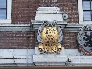
In the Netherlands, a water board, water council or water authority is a regional governing body solely charged with the management of surface water in the environment. Water boards are independent of administrative governing bodies like provinces and municipalities. In general, they are responsible for managing rivers and canals, issues with the flow of watercourses and drainage issues, water collection, flood and erosion prevention and provision of potable water. They manage polder systems, water levels, water barriers and locks, enforcements, water quality and sewage treatment in their respective regions. The concept of a coordinating "High Water Authority" (Hoogheemraadschap) originated in what now is the province of South Holland in the 12th century.

The name Rijnland means "Rhineland" in Dutch. When referring to the Rhine in Germany, "Rijnland" has the same meaning as "Rhineland" in English or "Rheinland" in German. However, "Rijnland" has a specific, different meaning in a Dutch context - the area along the Oude Rijn.

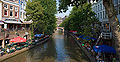
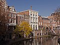
The Vaartse Rijn is a canal connecting the city of Utrecht with Nieuwegein and the Lek river in the Dutch province of Utrecht. The Vaartse Rijn was formerly a major shipping route between Utrecht and the Rhine basin.

Tivoli is a popular music venue and cultural center in Utrecht, Netherlands. Tivoli is run by a non-profit organisation. The original organisation dates back to 1823 and functioned as a relaxing place outside the city's Stadsbuitengracht. In May 2014 Tivoli "Oudegracht" closed its doors. A large new venue, named TivoliVredenburg, came to existence when Tivoli and the former Muziekcentrum Vredenburg merged as part of the fusion between the two, with TivoliVredenburg having 5 event halls with a capacity of 5500 people. Tivoli "De Helling", formerly known as "De Vloer" before they went bankrupt in 2003 and after Tivoli decided to reopen and rebrand the venue, remained to continue as an independent music venue.
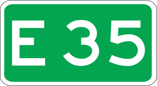
European route E 35 (E 35) is a north–south European route, running from Amsterdam in the Netherlands to Rome in Italy. In the Netherlands, the highway runs from its northern terminus in Amsterdam eastwards through Utrecht and Arnhem to the German border, near Zevenaar. The road runs concurrently with three other motorways over its entire length, starting on Rijksweg 10 (A10) around Amsterdam, then A2 from southern Amsterdam up to Utrecht, and the last part on A12 until it reaches the German border in the east.