
Lake Ladoga is a freshwater lake located in the Republic of Karelia and Leningrad Oblast in northwestern Russia, in the vicinity of Saint Petersburg.

The Gambia is a very small and narrow African country with the border based on the Gambia River. The country is less than 48 kilometres (30 mi) wide at its greatest width. The country's present boundaries were defined in 1889 after an agreement between the United Kingdom and France. It is often claimed by Gambians that the distance of the borders from the Gambia River corresponds to the area that British naval cannon of the time could reach from the river's channel. However, there is no historical evidence to support the story, and the border was actually delineated using careful surveying methods by the Franco-British boundary commission. The Gambia is almost an enclave of Senegal and is the smallest country on mainland Africa.
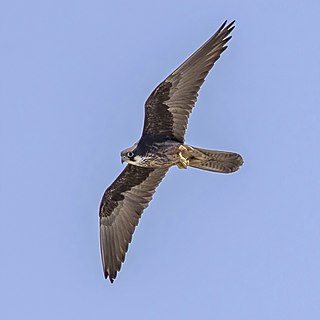
Eleonora's falcon is a medium-sized falcon. It belongs to the hobby group, a rather close-knit number of similar falcons often considered a subgenus Hypotriorchis. The sooty falcon is sometimes considered its closest relative, but while they certainly belong to the same lineage, they do not seem to be close sister species. The English name and the species name eleonorae commemorate Eleanor of Arborea, Queen or Lady-Judge and national heroine of Sardinia, who in 1392, under the jurisdiction conferred by the Carta de Logu, became the first ruler in history to grant protection to hawk and falcon nests against illegal hunters. The genus name falco is from Late Latin falx, falcis, a sickle, referring to the claws of the bird.

Wootton Creek is a tidal estuary that flows into the Solent on the north coast of the Isle of Wight. The estuary has also been known in the past as "Fishbourne Creek", "Wootton River" and "Wootton Haven".

The sooty falcon is a medium-sized falcon breeding from northeastern Africa to the southern Persian Gulf region. The word sooty means to be covered in soot (ash), and is used to describe the color of the Sooty Falcon. Hence, the falcon gets its name from its color, the color of soot.
Wassaw Sound is a bay of the Atlantic Ocean on the coast of Georgia, United States near Savannah at the mouth of the Wilmington River.

The River Oykel is a major river in northern Scotland that is famous for its salmon fishing. It rises on Ben More Assynt, a few miles from Ullapool on the west coast of Scotland, and drains into the North Sea via the Kyle of Sutherland. Traditionally it has marked the boundary between Ross to the south and Sutherland to the north.
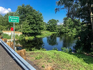
The Palmer River is a river in the U.S. states of Massachusetts and Rhode Island. It flows approximately 17 km (11 mi).

KQSF is a Top 40 radio station licensed to Dell Rapids, South Dakota; it serves the Sioux Falls, South Dakota area. It first began broadcasting in 1998 under the call sign KSOB. The station is currently owned by Duey E. Wright, through licensee Midwest Communications, Inc.

Bustillo de la Vega is a municipality located in the province of Palencia, Castile and León, Spain. According to the 2004 census (INE), the municipality has a population of 363 inhabitants.

Cantabrana is a municipality located in the province of Burgos, Castile and León, Spain. According to the 2004 census (INE), the municipality has a population of 39 inhabitants.

Bourj El Baroud is a ruined watchtower located somewhat south of the mouth of Oued Ksob near Essaouira, Morocco. This structure is located on a broad sandy beach directly across from Phoenician ruins at the southeast tip of the main islet of Iles Purpuraires. This beach is likely the one referred to in Herodotus' account of the Phoenicians' trading with the indigenous peoples of this part of western Morocco. About one kilometre inland is the village of Diabat.

Diabat is a village in western Morocco near the coast of the Atlantic Ocean about five kilometres south of the city of Essaouira. The Bordj El Berod is a ruined watchtower located somewhat south of the mouth of Oued Ksob near about one kilometre west of Diabat.

Belubula River, a perennial river that is part of the Lachlan catchment within the Murray–Darling basin, is located in the central west region of New South Wales, Australia.
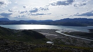
Tunulliarfik Fjord is a fjord near Qaqortoq in the Kujalleq municipality in southern Greenland. It is the inner section of Skovfjord (Skovfjorden). In times of the Norse settlement in southern Greenland, it was known as Eiriksfjord.
The New Westminster Land District is one of 59 land districts of British Columbia, Canada, which are the underlying cadastral divisions of that province, created with rest of those on Mainland British Columbia via the Lands Act of the Colony of British Columbia in 1860. The British Columbia government's BC Names system, a subdivision of GeoBC, defines a land district as "a territorial division with legally defined boundaries for administrative purposes". All land titles and surveys use the Land District system as the primary point of reference, and entries in BC Names for placenames and geographical objects are so listed.
Graptolite Island is an island 0.8 km (0.50 mi) long in the north-east part of Fitchie Bay, lying off the south-east portion of Laurie Island in the South Orkney Islands of Antarctica. James Weddell's chart published in 1825 shows two islands in essentially this position. Existence of a single island was determined in 1903 by the Scottish National Antarctic Expedition under William Speirs Bruce, who so named it because what were thought to be graptolite fossils were found there. Later analysis showed that the fossils on Graptolite Island were merely the remains of ancient plants.
The Lower Snake River Wind Project is the newest and largest wind farm operated by Puget Sound Energy, and is located in Washington’s Garfield and Columbia counties. The wind farm is made up of 149 Siemens wind turbines rated at 2.3 MW each for a maximum generating capacity of 343 MW. The project was estimated to create up to 150 temporary jobs and 25 permanent jobs.
Coolaburragundy River, a perennial stream that is part of the Talbragar catchment within the Murray–Darling basin, is located in the Orana district of New South Wales, Australia.

