Iles Purpuraires

Last updated
Iles Purpuraires
Iles Purpuraires with Mogador island in the background seen from the Essaouira citadel.jpg
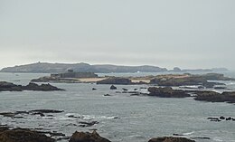
Iles Purpuraires, including Mogador island, seen from the Essaouira citadel
Morocco location map.svg
Red pog.svg
Iles Purpuraires
Geography
Location North Atlantic Ocean
Coordinates 31°29′50″N9°47′12″W / 31.49722°N 9.78667°W / 31.49722; -9.78667 Coordinates: 31°29′50″N9°47′12″W / 31.49722°N 9.78667°W / 31.49722; -9.78667
Major islands Mogador Island
Administration
Region Marrakesh-Safi
Province Essaouira Province
Official nameArchipel et dunes d'Essawira
Designated15 January 2005
Reference no.1469 [1]

Iles Purpuraires are a set of small islands off the western coast of Morocco at the bay located at Essaouira, the largest of which is Mogador Island. These islands were settled in antiquity by the Phoenicians, chiefly to exploit certain marine resources and as a promontory fort. (Hogan, 2007) Roman occupation of western Morocco beginning in the 2nd century BC continued the use of the islets, principally for manufacture of a royal blue dye from certain marine organisms. Neolithic archaeological studies in this area indicate indigenous peoples of western Morocco fished in this locale circa 3000 to 2000 BC. (Trakadas, 2002) The islands have been designated as a protected Ramsar site since 2005. [1]

Island Any piece of sub-continental land that is surrounded by water

An island or isle is any piece of sub-continental land that is surrounded by water. Very small islands such as emergent land features on atolls can be called islets, skerries, cays or keys. An island in a river or a lake island may be called an eyot or ait, and a small island off the coast may be called a holm. A grouping of geographically or geologically related islands is called an archipelago, such as the Philippines.

Morocco Country in North Africa

Morocco, officially the Kingdom of Morocco, is a country located in the Maghreb region of North West Africa with an area of 710,850 km2 (274,460 sq mi). Its capital is Rabat, the largest city Casablanca. It overlooks the Mediterranean Sea to the north and the Atlantic Ocean to the west. Morocco claims the areas of Ceuta, Melilla and Peñón de Vélez de la Gomera, all of them under Spanish jurisdiction.

Essaouira City and Wilaya in Marrakesh-Safi, Morocco

Essaouira, formerly known as Mogador, is a city in the western Moroccan economic region of Marrakesh-Safi, on the Atlantic coast. The modern name means "the little rampart", a reference to the fortress walls that still enclose part of the city.

Related Research Articles

Tyrian purple, also known as Tyrian red, Phoenician purple, royal purple, imperial purple or imperial dye, is a reddish-purple natural dye. It is a secretion produced by several species of predatory sea snails in the family Muricidae, rock snails originally known by the name Murex. In ancient times, extracting this dye involved tens of thousands of snails and substantial labor, and as a result, the dye was highly valued. The main chemical is 6,6′-dibromoindigo.

Promontory fort Fortification, usually dating from the Iron Age

A promontory fort is a defensive structure located above a steep cliff, often only connected to the mainland by a small neck of land, thus using the topography to reduce the ramparts needed. Although their dating is problematic, most seem to date to the Iron Age. They are mainly found in Brittany, Ireland, the Orkney Islands, the Isle of Man, Devon and Cornwall.

El Jadida Place in Casablanca-Settat, Morocco

El Jadida is a port city on the Atlantic coast of Morocco, located 106 km south of the city of Casablanca in the region of Doukkala-Abda and the province of El Jadida. It has a population of 194,934. From the sea, El Jadida's old city has a very "un-Moorish" appearance; it has massive Portuguese walls of hewn stone.

A Ramsar site is a wetland site designated to be of international importance under the Ramsar Convention.

The Canary Current is a wind-driven surface current that is part of the North Atlantic Gyre. This eastern boundary current branches south from the North Atlantic Current and flows southwest about as far as Senegal where it turns west and later joins the Atlantic North Equatorial Current. The current is named after the Canary Islands. The archipelago partially blocks the flow of the Canary Current.

Larne Lough lake in the United Kingdom

Larne Lough is a sea lough or inlet in County Antrim, Northern Ireland. The lough lies between Islandmagee and the mainland. At its mouth is the town of Larne. It is designated as an area of special scientific interest, a special protection area, and a Ramsar site to protect the wetland environment, particularly due to the presence of certain bird species and shellfish.

Elizabeth and Middleton Reefs Marine National Park Reserve geographical object

Elizabeth and Middleton Reefs Marine National Park Reserve is a former Marine protected area consisting of waters around Elizabeth and Middleton Reefs located at the south-eastern end of the Coral Sea Islands, an Australian territory in the Coral Sea and the north-western Tasman Sea. It was incorporated into the new Lord Howe Commonwealth Marine Reserve in December 2012. The two reefs also form a Ramsar site, having been listed as Ramsar Site 1223, on 21 October 2002, under the Ramsar Convention as a wetland of international importance.

Marrakesh-Tensift-El Haouz Region in Morocco

Marrakesh-Tensift-El Haouz was formerly one of the sixteen regions of Morocco from 1997 to 2015. It was situated in central Morocco. It covered an area of 31,160 km² and had a population of 3,576,673. The capital is Marrakesh. In 2015, the region annexed Safi and Youssoufia Provinces to become the Region of Marrakesh-Safi.

Punics people from Ancient Carthage

The Punics, also known as Carthaginians, were a people from Ancient Carthage who traced their origins to the Phoenicians. Punic is the English adjective, derived from the Latin adjective punicus to describe anything Carthaginian. Their language, Punic, was a dialect of Phoenician.

Port Phillip Heads Marine National Park Protected area in Victoria, Australia

The Port Phillip Heads Marine National Park is a marine protected area located in the vicinity of the bay of Port Phillip, between the Bellarine and Mornington Peninsulas, in Victoria, Australia. The 3,580-hectare (8,800-acre) marine national park comprises six separate sites located approximately 60 kilometres (37 mi) south-west of Melbourne and stretches along 40 kilometres (25 mi) of coastline of Victoria.

Oued Ksob river in Morocco

Oued Ksob is a river in western Morocco that discharges to the Atlantic Ocean on a broad beach slightly south of the city of Essaouira and slightly north of the village of Diabat. The mouth of the river along with the nearby Iles Purpuraires is known for sighting of the rare species Eleonora's falcon. To the south of the Ksob mouth is a ruined watchtower known as the Bordj El Berod.

Bordj El Berod

Bourj El Baroud is a ruined watchtower located somewhat south of the mouth of Oued Ksob near Essaouira, Morocco. This structure is located on a broad sandy beach directly across from Phoenician ruins at the southeast tip of the main islet of Iles Purpuraires. This beach is likely the one referred to in Herodotus' account of the Phoenicians' trading with the indigenous peoples of this part of western Morocco. About one kilometre inland is the village of Diabat.

Diabat human settlement in Morocco

Diabat is a village in western Morocco near the coast of the Atlantic Ocean about five kilometres south of the city of Essaouira. The Bordj El Berod is a ruined watchtower located somewhat south of the mouth of Oued Ksob near about one kilometre west of Diabat.

R301 is a coastal highway in Western Morocco connecting the cities of Essaouira and El Jadida. This paved highway varies between two and four lanes of travel. In many locations views of the Atlantic Ocean coastline are available. There are a number of coastal bridges spanned by the B301 including one over the Wadi Oum er-Rbia estuary at Azemmour. At the southern part of the R301 lies some of the earliest recorded settlement history in Morocco: the archaeological ruins of Mogador, which were originally Phoenician from at least as early as the first millennium BC.

Churchill Island Marine National Park Protected area in Victoria, Australia

The Churchill Island Marine National Park is a protected marine national park located in Western Port, Victoria, Australia. The 670-hectare (1,700-acre) marine park is located south of Rhyll, on the north-eastern shore of Phillip Island, in Western Port.

André Jodin is an archaeologist known for explorations and excavations in North Africa, especially in Morocco. André Jodin (1921-2003) studied Phoenician and Punic sites in Morocco in the 1960s and 1970s. Mogador (Essaouira) (Kerné?) became then the most extreme place of Phoenician merchants in the South Atlantic African coast. His contribution to Volubilis followed Carcopino’s thesis about the regia of king Juba II in Morocco. In the 1980s André Jodin participated in the archaeological study of the Iberian necropolis of Cabezo Lucero. References: -A. Jodin: Mogador. Comptoir phénicien du Maroc atlantique, Rabat, 1966. -A. Jodin: Volubilis Regia Iubae, Paris, 1987. -A. Jodin et al.: La nécropole ibérique de Cabezo Lucero, Madrid, 1993.

Mogador Island island

Mogador Island is the main island of the Iles Purpuraires near Essaouira in Morocco. It is about 3 kilometres long and 1.5 kilometres wide, and lies about 1.5 kilometres from Essaouira.

Trevelgue Head Headland in Cornwall

Trevelgue Head, also known as Porth Island, is a headland a short distance north-east of Newquay, in Cornwall, England. It is adjacent to Porth and is at the eastern end of Newquay Bay.

Granite Island (Victoria) island in Western Australia, Australia

Granite Island is a small, uninhabited granite island in Corner Inlet near the northern coast of Wilsons Promontory, in Victoria, Australia.

References

  1. 1 2 "Archipel et dunes d'Essawira". Ramsar Sites Information Service. Retrieved 11 September 2018.