
The Medjerda River, the classical Bagrada, is a river in North Africa flowing from northeast Algeria through Tunisia before emptying into the Gulf of Tunis and Lake of Tunis. With a length of 450 km (280 mi), it is the longest river of Tunisia. It is also known as the Wadi Majardah or Mejerha.
Lac Léré is one of two departments in Mayo-Kebbi Ouest, a region of Chad. Its capital is Léré.
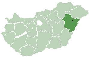
Mezőpeterd is a village in Hajdú-Bihar county, in the Northern Great Plain region of eastern Hungary.

Villasbuenas de Gata is a municipality located in the province of Cáceres, Extremadura, Spain. According to the 2005 census (INE), the municipality has a population of 490 inhabitants.
Hohe Rhön is a Verwaltungsgemeinschaft in the district Schmalkalden-Meiningen, in Thuringia, Germany. The seat of the Verwaltungsgemeinschaft is in Kaltennordheim.

Icebreaker Glacier is a large valley glacier 10 miles (16 km) northeast of Mount Monteagle that flows southeast from the Mountaineer Range to Lady Newnes Bay, Victoria Land, Antarctica. Below Hermes Point its flow coalesces with that of Fitzgerald Glacier. The glacier was named by the New Zealand Geological Survey Antarctic Expedition, 1958–59, as a tribute to the work of the complements of U.S. Navy, and U.S. Coast Guard icebreakers in Antarctic exploration, in supporting scientists and in aiding other ships.
Aurora Glacier is a large glacier draining that part of Ross Island between Mount Erebus and Mount Terra Nova, and flowing south into McMurdo Ice Shelf. It was named by A.J. Heine in 1963 after the Aurora, the ship of the Ross Sea Party of the British expedition under Ernest Shackleton, 1914–17.

Dybków is a village in the administrative district of Gmina Sieniawa, within Przeworsk County, Subcarpathian Voivodeship, in south-eastern Poland. It lies approximately 2 kilometres (1 mi) south of Sieniawa, 14 km (9 mi) north-east of Przeworsk, and 47 km (29 mi) east of the regional capital Rzeszów.
Łąków is a village in the administrative district of Gmina Krzeszyce, within Sulęcin County, Lubusz Voivodeship, in western Poland. It lies approximately 19 kilometres (12 mi) north of Sulęcin and 15 km (9 mi) south-west of Gorzów Wielkopolski.
Czyżewka is a settlement in the administrative district of Gmina Choszczno, within Choszczno County, West Pomeranian Voivodeship, in north-western Poland. It lies approximately 15 kilometres (9 mi) east of Choszczno and 75 km (47 mi) east of the regional capital Szczecin.
Hořesedly is a village and municipality in Rakovník District in the Central Bohemian Region of the Czech Republic.
Betzenberg (Schönbuch) is a mountain in Baden-Württemberg, Germany.
Sugalepa is a village in Järva Parish, Järva County in northern-central Estonia.
Barrett Glacier is a glacier draining from the north slopes of the Prince Olav Mountains, about 15 nautical miles (30 km) long, flowing between the Longhorn Spurs and the Gabbro Hills to the Ross Ice Shelf. It was named by the Southern Party of the New Zealand Geological Survey Antarctic Expedition (1963–64) for Peter Barrett, a geologist with that party.
Mount Terra Nova is a snow-covered inactive volcanic mountain, 2,130 m (6,990 ft), between Mount Erebus and Mount Terror on Ross Island. It was first mapped by the Discovery expedition in 1901–04, and named for Terra Nova, the relief ship for this expedition and the British Antarctic Expedition, 1910–13.

Rachel Glacier is a glacier on the east coast of Graham Land, 6 nautical miles (11 km) long, flowing east between Krupen Ridge and Padesh Ridge to enter Exasperation Inlet southwest of Mihaylovski Crag. The name, applied by United Kingdom Antarctic Place-Names Committee (UK-APC), is taken from Herman Melville's Moby Dick, the Rachel being a ship from Nantucket which met the Pequod and brought news of a lost whaleboat.
Lammers Glacier is a large glacier flowing east along the north side of Godfrey Upland into the Traffic Circle and Mercator Ice Piedmont, on the east coast of Graham Land, Antarctica. This glacier appears indistinctly in an aerial photograph taken by Sir Hubert Wilkins on December 20, 1928, but shows more clearly in aerial photographs taken by Lincoln Ellsworth in 1935 and the United States Antarctic Service in 1940. It was resighted in 1947 by the Ronne Antarctic Research Expedition under Finn Ronne, who named it for Lester Lammers, who had contributed nine grown husky dogs and four puppies to the expedition.

Sulakyurt (Sarzep) is a village in the central district (Ardahan) of Ardahan Province, Turkey. It is situated in a high plateau at 41°10′N42°37′E. Distance to Ardahan is 10 kilometres (6.2 mi). The population of Sulakyurt is 999 as of 2010.
The Oued Zitoun is a river of Tunisia, North Africa.

Henchir el Merazguia is a location in Tunisia, North Africa.
