Mount Rexford is a prominent 2,329-metre (7,641-foot) mountain summit located in the Cascade Mountains of southwestern British Columbia, Canada. It is situated 3.5 km (2 mi) north of the Canada–United States border, 7 km (4 mi) west of Chilliwack Lake, and 5.5 km (3 mi) east of Slesse Mountain, which is its nearest higher neighbor. Precipitation runoff from the peak drains into Nesakwatch and Centre Creeks, both tributaries of the Chilliwack River. Originally known as Ensawkwatch, the mountain was named for an early settler in the area, Rexford, who had a cabin near Slesse Creek and had trap lines in the vicinity. The mountain has two subsidiary peaks known as the Nesakwatch Spires. The mountain's name was officially adopted on June 2, 1950, by the Geographical Names Board of Canada. Mount Rexford was first climbed in July 1951 by Herman Genschorek and Walt Sparling via the West Ridge.

Monster Tower is a 600-foot (180-meter) tall sandstone tower located in the Island in the Sky District of Canyonlands National Park, in San Juan County, Utah, United States.

Candlestick Tower is a 450-foot-tall (140 m) sandstone butte located in the Island in the Sky District of Canyonlands National Park, in San Juan County, Utah. Its descriptive name comes from its resemblance to a candlestick. Candlestick Tower is composed of Wingate Sandstone, which is the remains of wind-borne sand dunes deposited approximately 200 million years ago in the Late Triassic.

Washer Woman is a 500-foot (150-meter) tall sandstone arch and tower located in the Island in the Sky District of Canyonlands National Park, in San Juan County, Utah. It is situated 300 feet northwest of the slightly higher Monster Tower. Washer Woman is so named because the feature gives the appearance of a washerwoman bent over a washtub. This geographical feature's name was officially adopted in 1986 by the U.S. Board on Geographic Names after previously having similar names such as Washer-Woman Arch and The Washer Woman. Washer Woman and Monster Tower are an eroded fin composed of Wingate Sandstone, which is the remains of wind-borne sand dunes deposited approximately 200 million years ago in the Late Triassic. Airport Tower is set 1.6 mi (2.6 km) to the east, and Mesa Arch is situated 1.5 mi (2.4 km) to the west. A short hike to Mesa Arch provides the easiest view of Washer Woman. Access to this formation is via the four-wheel drive White Rim Road, which is the other option to see it. The top of this geological formation rises 1,300 feet above the road in approximately one mile. Precipitation runoff from Washer Woman drains southeast into the nearby Colorado River via Buck Canyon.
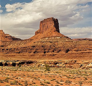
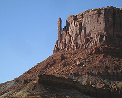
Airport Tower is a 700-foot (210-meter) tall sandstone butte located in the Island in the Sky District of Canyonlands National Park, in San Juan County, Utah. It is situated 1.64 mile east of Washer Woman, which is a towering arch similar in height. Each are composed of Wingate Sandstone, which is the remains of wind-borne sand dunes deposited approximately 200 million years ago in the Late Triassic. The nearest higher neighbor is Monster Tower, 1.6 mi (2.6 km) to the west, Tiki Tower is one-half mile northwest, and Mesa Arch is situated 3.2 mi (5.1 km) to the west. A short hike to Mesa Arch provides the easiest view of Airport Tower. Access to this tower is via the four-wheel drive White Rim Road, which is another option to see Airport Tower. The top of this geological formation rises 1,400 feet above the road in less than one mile. Precipitation runoff from Airport Tower drains southeast into the nearby Colorado River via Buck and Lathrop Canyons. This geographical feature's name was officially adopted in 1986 by the U.S. Board on Geographic Names. It was so named because the rock formation resembles the appearance of an airport control tower.

Zeus and Moses are a pair of 500-foot-tall (150 m) sandstone formations located in the Island in the Sky District of Canyonlands National Park, in San Juan County, Utah, United States. These rock towers' names refer to Zeus, a god in Greek mythology, and Moses, an important prophet in several religious traditions. Zeus and Moses are composed of Wingate Sandstone, which is the remains of wind-borne sand dunes deposited approximately 200 million years ago in the Late Triassic. This formation is situated in Taylor Canyon, 3 mi (4.8 km) north-northeast of Upheaval Dome. Access to the towers is via the four-wheel-drive White Rim Road, and a spur road into Taylor Canyon. The top of this geological formation rises 900 feet above the canyon floor at road's end, approximately one-half mile away. Precipitation runoff from Zeus and Moses drains into the nearby Green River via Taylor Canyon.

Buttes of the Cross is two sandstone summits located in the northern reach of Glen Canyon National Recreation Area, in Wayne County of Utah, United States. The larger and higher south butte reaches an elevation of 5,642 feet, whereas the north butte rises to 5,569 feet, with approximately 0.6 miles (0.97 km) separation between them. When viewed from the north-northeast near Labyrinth Canyon, they align to form the shape of a cross, creating the appearance of a single butte. The name "Butte of the Cross" was first applied by John Wesley Powell during the Powell Geographic Expedition of 1869. A few miles further down the Green River, Powell finds that this geographical feature is two buttes when viewed from the east, so it was renamed Buttes of the Cross. Buttes of the Cross towers over 1,400 feet above its surrounding terrain. It is situated 6.8 miles west of Candlestick Tower, and one-half mile outside the boundary of Canyonlands National Park.

Ekker Butte is a 6,260-foot (1,910-meter) elevation summit located in the northern reach of Glen Canyon National Recreation Area, in Wayne County of Utah, United States. It is situated seven miles southeast of Buttes of the Cross, six miles northeast of Elaterite Butte, and less than two miles outside the boundary of Canyonlands National Park, where it towers over 1,400 feet above the surrounding terrain. Distant views of this remote butte can be seen from the Grand View Point and Green River Overlooks at Island in the Sky of Canyonlands National Park. This geological landmark is named for the pioneering Art Ekker family which operated the nearby Robbers Roost Ranch and grazed cattle on land adjacent to the nearby Maze. Arthur Benjamin Ekker (1911–1978) took Robert Redford on a tour of nearby Robbers Roost, the hideout of outlaw Butch Cassidy and the Wild Bunch.

Chip and Dale Towers are two 300-foot (91-meter) tall sandstone towers located in the Island in the Sky District of Canyonlands National Park, in San Juan County, Utah. Dale Tower rises to an elevation of 5,620 feet, whereas the lower Chip Tower is 5,420-feet. Airport Tower is set 2.5 mi (4.0 km) to the southwest, and Dead Horse Point State Park overlook is situated 4.5 mi (7.2 km) to the north-northeast. Chip and Dale Towers are an eroded fin composed of hard, fine-grained Wingate Sandstone, which is the remains of wind-borne sand dunes deposited approximately 200 million years ago in the Late Triassic. This Wingate Sandstone overlays a softer layer of the Chinle Formation. Access to the towers is via the four-wheel drive White Rim Road, and a scramble to reach the base. The top of the towers rise over 1,000 feet above the road in approximately one-half mile. Precipitation runoff from Chip and Dale Towers drains east to the nearby Colorado River.

The Sixshooter Peaks are two iconic sandstone summits located in Bears Ears National Monument in San Juan County, Utah, United States. The larger and higher North Sixshooter Peak rises to an elevation of 6,379 feet, whereas South Sixshooter Peak rises to 6,154 feet, with approximately 1.5 miles (2.4 km) separation between the two. These buttes tower nearly 1,400 feet above the surrounding terrain, and are historic landmarks visible from State Route 211 between Newspaper Rock and the Needles District of Canyonlands National Park. They are situated 1.5 mile outside the boundary of the park, and four miles northwest of Bridger Jack Butte. Variant names for the peaks include "North Six-Shooter Peak", "South Six-shooter Peak", "Six Shooter Peaks", and "Six-shooter Peak". They are so named because of their resemblance to a pair of revolvers pointing skyward.

Bridger Jack Butte is a sandstone butte located in Bears Ears National Monument, in San Juan County, Utah, United States. Set at the northern tip of Bridger Jack Mesa and above the confluence of Indian and Lavender Creeks, the summit rises to an elevation of 5,890 feet, and towers over 700 feet above the surrounding terrain and floor of Lavender Canyon to its west. This landmark is situated four miles southeast of the Sixshooter Peaks, and is visible from State Route 211 between Newspaper Rock and the Needles District of Canyonlands National Park. "Bridger Jack" was a Paiute medicine man.

Tiki Tower is a thin 300-foot (91-meter) tall sandstone pinnacle located in the Airport Tower/Monster Tower/Washer Woman area of the Island in the Sky District of Canyonlands National Park, in San Juan County, Utah. It is situated one-half mile northwest of Airport Tower, and is composed of Wingate Sandstone, which is the remains of wind-borne sand dunes deposited approximately 200 million years ago in the Late Triassic. Access to this tower is via the four-wheel-drive White Rim Road. The top of this spire rises 1,100 feet above the road in a little more than one mile. Precipitation runoff from Tiki Tower drains southeast into the nearby Colorado River via Buck and Lathrop Canyons. The first ascent of Tiki Tower was made in November 1991 by Jeff Widen and Mitch Allen, via Brave Little Toaster, with Fred Lifton and Paul Frank working the first pitch.
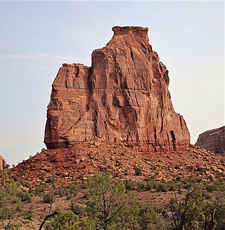
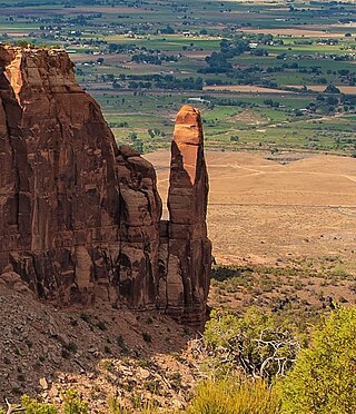
Independence Monument is a 5,739-foot-elevation sandstone pillar located in Colorado National Monument, in Mesa County of western Colorado, United States. This iconic 450-foot-high landmark is situated one mile southeast of the monument's visitor center, and 9 miles (14 km) west of the community of Grand Junction, where it towers above the floor of Monument Canyon and Wedding Canyon. It is a popular climbing destination, and can be seen from Rim Rock Drive.
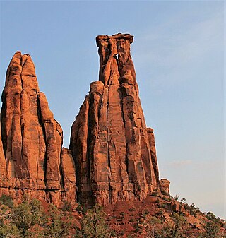
Kissing Couple is a 5,815-foot-elevation (1,772-meter) sandstone pillar located in Colorado National Monument, in Mesa County of western Colorado, United States. This iconic 400-foot-high tower is situated on the west side of Monument Canyon, 1.5 mile southeast of the monument's visitor center, and nine miles (14 km) west of the community of Grand Junction. It is also a half-mile south-southeast of another popular climbing destination, Independence Monument, and both can be seen from viewpoints along Rim Rock Drive. It is so named because it resembles an embracing couple. This geographical feature's name was officially adopted in 1982 by the United States Board on Geographic Names. Older USGS maps have the feature's name misplaced by about one-half mile to the southeast. The first ascent of the summit was made May 4, 1960, by Layton Kor, Harvey Carter, and John Auld via the five pitch, class 5.11a route named Long Dong Wall. The first free ascent was made in 1977 by Andy Petefish, Tom Stubbs, and Jim Pearson. Some climbers alternatively refer to Kissing Couple as "Bell Tower."

Pipe Organ is a 5,731-foot-elevation (1,747-meter) sandstone pillar located in Colorado National Monument, in Mesa County of western Colorado, United States. This 400+ foot tower is situated in Wedding Canyon, less than one-half mile east of the monument's visitor center, and 9 miles (14 km) west of the community of Grand Junction. It is also immediately northwest of another popular climbing destination, Independence Monument, and both can be seen from viewpoints along Rim Rock Drive. The first ascent of the summit was made January 31, 1961, by John Auld, Gary Ziegler, Jim Dyson, and John Kuglin. Pipe Organ has a subsidiary summit unofficially named Organ Pipe Spire on the east aspect, which the National Park Service refers to as Praying Hands. This 325-foot-high subsidiary peak was originally named Squall Spire in 1976 by Harvey T. Carter of the first ascent party.
Sentinel Spire is a 5,500-foot-elevation (1,676-meter) sandstone pillar located in Colorado National Monument, in Mesa County of western Colorado, United States. This 200-foot freestanding tower is situated in Wedding Canyon, one-half mile east of the monument's visitor center, and 9 miles (14 km) west of the community of Grand Junction. It is also immediately south of Window Rock, and north of another climbing destination, Pipe Organ, both of which can be seen from viewpoints along Rim Rock Drive. The first ascent of the summit was made May 3, 1960, by Layton Kor, Harvey Carter, and John Auld via the class 5.10 route, Fast Draw. This was the day before the climbers also made the first ascent of nearby Kissing Couple. The first solo ascent was made by Ron Olevsky in March 1976, and the first free ascent was made by Andy Petefish and John Christenson in 1978. Some climbers refer to Sentinel Spire as Watusi Spear.

Grand View Spire is a 5,821-foot-elevation (1,774-meter) sandstone pillar located in Colorado National Monument, in Mesa County of western Colorado, United States. This 400-foot tower is situated on the west side of Monument Canyon, one mile southeast of the monument's visitor center, and 9 miles (14 km) west of the community of Grand Junction. It is also 0.32 mile immediately south of Independence Monument, and 0.27 mile northwest of another climbing destination, Kissing Couple. Its unofficial name relates to its position at the tip of Grand View Overlook, one of several scenic viewpoints along Rim Rock Drive.

Terra Tower is a 5,790-foot-elevation (1,760-meter) sandstone pillar located in Colorado National Monument, in Mesa County of western Colorado, United States. This 350-foot-high tower is situated on the Redlands escarpment, approximately seven miles west of the community of Grand Junction. Topographic relief is significant as it rises 1,000 feet above the Tiara Rado Golf Course in approximately one-half mile. The first ascent of the summit was made in 1979 by Harvey Carter and Tom Merrill via the class 5.11 route, Way Bazaar.

Royal Tower is an 8,130-foot-elevation (2,478-meter) mountain summit in Alaska.

Islet in the Sky is a sandstone pillar located within Canyonlands National Park, in San Juan County, Utah, United States. It is situated in the Island in the Sky District of the park, one mile (1.6 km) east of the Island in the Sky paved road that leads to Grand View Point. This spire is composed of Wingate Sandstone, which is the remains of wind-borne sand dunes deposited approximately 200 million years ago in the Late Triassic. Precipitation runoff from Islet in the Sky drains east to the nearby Colorado River via Buck Canyon. Access is via the White Rim Road which traverses between this remote spire and the river.