Notes
Coordinates: 46°01′03″N121°10′25″W / 46.01750°N 121.17361°W
| | This Klickitat County, Washington state location article is a stub. You can help Wikipedia by expanding it. |
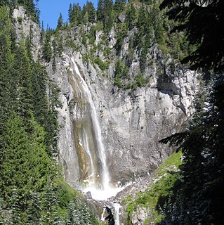
Outlet Falls is a 69-foot plunge fed by Outlet Creek which flows out of farmland in Klickitat County, Washington. Its watercourse, Outlet Creek, is fed by several springfed tributaries and agricultural runoff (manure and fertilizer). The perennial drop is formed as Outlet Creek erodes into the 200-foot-deep Klickitat Canyon and hurtles itself into a huge bowl. [1] It is located several miles east of the town of Glenwood. [2]
Coordinates: 46°01′03″N121°10′25″W / 46.01750°N 121.17361°W
| | This Klickitat County, Washington state location article is a stub. You can help Wikipedia by expanding it. |

Dallesport is an unincorporated community and census-designated place (CDP) in Klickitat County, Washington, United States. The population was 1,202 at the 2010 census.

The Snoqualmie River is a 45-mile (72 km) long river in King County and Snohomish County in the U.S. state of Washington. The river's three main tributaries are the North, Middle, and South Forks, which drain the west side of the Cascade Mountains near the town of North Bend and join near the town of Snoqualmie just above the Snoqualmie Falls. After the falls the river flows north through rich farmland and the towns of Fall City, Carnation, and Duvall before meeting the Skykomish River to form the Snohomish River near Monroe. The Snohomish River empties into Puget Sound at Everett. Other tributaries of the Snoqualmie River include the Taylor River and the Pratt River, both of which enter the Middle Fork, the Tolt River, which joins at Carnation, and the Raging River at Fall City.

The Klickitat River is a tributary of the Columbia River, nearly 96 miles (154 km) long, in south-central Washington in the United States. It drains a rugged plateau area on the eastern side of the Cascade Range northeast of Portland, Oregon. In 1986, 10 miles (16 km) of the river were designated Wild and Scenic from the confluence with Wheeler Creek, near the town of Pitt, to the confluence with the Columbia River.

Uvas Canyon County Park is a 1,147-acre (464 ha) natural park located in upper Uvas Canyon on the eastern side of the Santa Cruz Mountains, west of Morgan Hill, California. The park has several small waterfalls, some of which flow perennially, that feed into tributaries confluent with Uvas Creek. The park is part of the Santa Clara County Parks System, and facilitates picnics, hiking and overnight camping. It is one of the few parks in the area that allows dogs in the campgrounds.
The Klickitat Trail is a 31-mile (50 km) rail trail along the Klickitat River in southern Washington in the Columbia River Gorge. The cycling and hiking trail offers river and canyon views throughout its length. It follows an old railroad corridor that at one time linked the towns of Lyle and Goldendale.

Bridal Veil Falls is a 1,328-foot (405 m) waterfall that flows from Lake Serene directly to the South Fork Skykomish River on the creek of the same name in the U.S. state of Washington. It is a perennial 150-foot (46 m) wide drop with four tiers, two of which are clearly visible. It is at 47.78950°N 121.56924°W.
Foss River Falls is a 650-foot (200 m) drop on the West Fork Foss River in the Alpine Lakes Wilderness Area, King County, Washington. Its sources are at Delta Lake, and the 70-foot (21 m)-wide drop flows year-round. The waterfall is split into two parts. Each part is split into several tiers.
Jordan Creek Falls drops 588 feet (179 m) along Jordan Creek in Skagit County, Washington. The cascade has a run of 250 feet (76 m) and is fed by two large lakes and a large watershed. The falls' elevation is at 3,086 feet (941 m).
There are four prominent waterfalls in the basin of a short tributary of Sulphide Creek, on the southeast flank of 9,127-foot (2,781m) Mount Shuksan in North Cascades National Park, Washington. Seahpo Peak Falls and Cloudcap Falls, the taller two of the three, are located on separate streams that converge and plunge over Rockflow Canyon Falls. The unnamed outlet stream from these waterfalls flows into Sulphide Creek, which flows into the Baker River. Another waterfall is Jagged Ridge Falls, on a tributary of the unnamed stream.
Berdeen Falls is a series of three waterfalls located in Whatcom County, Washington. The 850-foot (260 m) falls are on a stretch of Bacon Creek downstream of Berdeen Lake.The drops include a 400-foot (120 m) horsetail, a 200-foot (61 m) bedrock slide, and a 250-foot (76 m) plunge waterfall.
Blum Creek is a small glacial tributary of the Baker River in Washington state, in the United States. It is sourced from the Hagan Glacier and another unnamed glacier on the north face of Mount Blum, and flows approximately 1.5 miles (2.4 km) from there to its mouth at the Baker River. Hagan Glacier is located below Mount Blum and the creek is also fed by runoff from the Blum Lakes, a set of six lakes south of Bacon Peak. The creek joins the Baker River two drainages downstream of Sulphide Creek, another Baker River glacial tributary. Blum Creek forms the waterfall Blum Basin Falls as it tumbles down a 1,680-foot (510 m) glacial cliff. The creek's watershed is an overwintering location for the local Rocky mountain goats.
The Taylor River is a river in King County in Washington.
Van Trump Creek, also called Van Trump Falls Creek or the Van Trump Fork of the Nisqually River, is a creek in Pierce County, Washington. It is a tributary of the Nisqually River, joining the river just above the mouth of the Paradise River. The creek is known for having several well known waterfalls along its course.

Christine Falls is a waterfall on Van Trump Creek in Pierce County, Washington. The falls are 69 feet (21 m) feet high and are best known for the Christine Falls Bridge spanning the lower drop. The upper drop is 32 feet (9.8 m) high and is almost impossible to film in tandem with the oft-photographed 37-foot (11 m) lower tier. The lower tier is probably one of the most commonly photographed locations in the Mount Rainier area.

Kautz Creek is a tributary of the Nisqually River, flowing from the Kautz Glacier, with its watershed in the Mount Rainier National Park of Washington. It drains southwest from Mount Rainier for about 6 miles (9.7 km) before it joins the Nisqually River near Mount Rainier Highway. It is notable for being a severe flooding hazard due to the volume of summer glacier melt and its frequently changing course. The 400-foot (120 m) Kautz Creek Falls on the headwaters of the creek was formed by the retreat of the Kautz Glacier in the past 50 years.

Eagle Creek is a tributary of the Columbia River in Multnomah and Hood River counties in the U.S. state of Oregon. It cuts through a narrow canyon in its 3,200 feet (980 m) descent to the Columbia River Gorge and is known for its concentration of 13 waterfalls in about 5 miles (8.0 km) distance. Eight major falls are on Eagle Creek and the East Fork Eagle Creek itself, while five are on its tributaries.
The Paradise River in Washington state, United States, is known for having a total of eight major waterfalls.
The Green Bowl is a gorge just southeast of Kinuseo Falls at the north end of Monkman Provincial Park in the Northern Rockies of British Columbia, Canada, northeast of the city of Prince George and south of the community of Tumbler Ridge.
Washington's 14th Legislative District is one of forty-nine districts in Washington state for representation in the state legislature.
Little Klickitat Falls is a 16-foot (4.9 m) waterfall that flows from Little Klickitat River, a tributary of Klickitat River, approximately 1095 feet above sea level, located in the U.S. state of Washington. Shortly downstream Little Klickitat River joins the Blockhouse Creek on the basalt tabletop of Horseshoe Bend canyon. While flow runs dry in the early season, Little Klickitat Falls may reach up to 100 feet wide in the flood seasons. Little Klickitat Falls is located north of Interstate 84 in the heart of steep canyons in central Klickitat County.