
In aviation, instrument flight rules (IFR) is one of two sets of regulations governing all aspects of civil aviation aircraft operations; the other is visual flight rules (VFR).
In aviation, visual flight rules (VFR) are a set of regulations under which a pilot operates an aircraft in weather conditions generally clear enough to allow the pilot to see where the aircraft is going. Specifically, the weather must be better than basic VFR weather minima, i.e., in visual meteorological conditions (VMC), as specified in the rules of the relevant aviation authority. The pilot must be able to operate the aircraft with visual reference to the ground, and by visually avoiding obstructions and other aircraft.

Air traffic control (ATC) is a service provided by ground-based air traffic controllers who direct aircraft on the ground and through a given section of controlled airspace, and can provide advisory services to aircraft in non-controlled airspace. The primary purpose of ATC is to prevent collisions, organize and expedite the flow of traffic in the air, and provide information and other support for pilots.

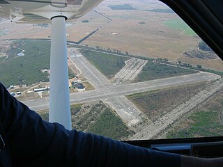
According to the International Civil Aviation Organization (ICAO), a runway is a "defined rectangular area on a land aerodrome prepared for the landing and takeoff of aircraft". Runways may be a human-made surface or a natural surface. Runways, taxiways and ramps, are sometimes referred to as "tarmac", though very few runways are built using tarmac. Takeoff and landing areas defined on the surface of water for seaplanes are generally referred to as waterways. Runway lengths are now commonly given in meters worldwide, except in North America where feet are commonly used.

An airfield traffic pattern is a standard path followed by aircraft when taking off or landing while maintaining visual contact with the airfield.
In aviation, a go-around is an aborted landing of an aircraft that is on final approach or has already touched down. A go-around can either be initiated by the pilot flying or requested by air traffic control for various reasons, such as an unstabilized approach or an obstruction on the runway.

A precision approach path indicator (PAPI) is a system of lights on the side of an airport runway threshold that provides visual descent guidance information during final approach. It is generally located on the left-hand side of the runway approximately 300 metres (980 ft) beyond the landing threshold of the runway.

In aviation, an instrument approach or instrument approach procedure (IAP) is a series of predetermined maneuvers for the orderly transfer of an aircraft operating under instrument flight rules from the beginning of the initial approach to a landing, or to a point from which a landing may be made visually. These approaches are approved in the European Union by EASA and the respective country authorities and in the United States by the FAA or the United States Department of Defense for the military. The ICAO defines an instrument approach as "a series of predetermined maneuvers by reference to flight instruments with specific protection from obstacles from the initial approach fix, or where applicable, from the beginning of a defined arrival route to a point from which a landing can be completed and thereafter, if landing is not completed, to a position at which holding or en route obstacle clearance criteria apply."

Perth Airport is a general-aviation airport located at New Scone, 3 nautical miles northeast of Perth, Scotland. The airport is used by private and business aircraft, and for pilot training. There are no commercial scheduled flights from the airport.

In aviation, holding is a maneuver designed to delay an aircraft already in flight while keeping it within a specified airspace; i.e. "going in circles."

In aviation, a crosswind landing is a landing maneuver in which a significant component of the prevailing wind is perpendicular to the runway center line.
In aviation, a run and break is a procedure used by high-performance aircraft to join an airfield traffic pattern without requiring the aircraft to spend a long time flying at low speed. As such, it is a procedure normally used by military aircraft at military airfields, however because it is also used by ex-military types it may sometimes be performed at civilian airfields, although it can be seen as comedic when performed by slow moving civilian aircraft, such as a PA-28.This maneuver is also known as initial and pitch; or in the US as an overhead maneuver or overhead break.
A portable collision avoidance system (PCAS) is a proprietary aircraft collision avoidance system similar in function to traffic collision avoidance system (TCAS). TCAS is the industry standard for commercial collision avoidance systems but PCAS is gaining recognition as an effective means of collision avoidance for general aviation and is in use the world over by independent pilots in personally owned or rented light aircraft as well as by flight schools and flying clubs. PCAS was manufactured by Zaon. Its main competitor is FLARM.

China Southern Airlines Flight 3456 (CZ3456/CSN3456) was a scheduled domestic passenger flight from Chongqing Jiangbei International Airport to Shenzhen Huangtian Airport. On 8 May 1997, the Boeing 737 performing this route crashed during the second attempt to land in a thunderstorm. The flight number 3456 is still used by China Southern and for the Chongqing-Shenzhen route but now with the Airbus A320 family or Boeing 737 Next Generation aircraft.
The Cotswold Gliding Club (CGC) is based at Aston Down airfield, between Cirencester and Stroud in Gloucestershire, South West England. The club maintains a fleet of aircraft for training purposes, and is a centre for cross-country gliding and competitions.
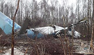
Aviastar-TU Flight 1906 was a Tupolev Tu-204 that crashed while attempting to land at Domodedovo International Airport, Moscow, Russia, in heavy fog on 22 March 2010. The aircraft was on a ferry flight from Hurghada International Airport, Egypt to Moscow, and had no passengers on board; all eight crew survived the accident, four with serious injuries requiring hospitalization and four with minor injuries. The accident was the first hull loss of a Tu-204 and the first hull loss for Aviastar-TU.

A signal square is an aerodrome equipment internationally defined at the annex 14 of the Convention on International Civil Aviation by the International Civil Aviation Organization.

West Auckland Airport Parakai West Auckland Airport is a general aviation (GA) airport on the North Western edge of Auckland, New Zealand. It is close to the town of Parakai and 2 nautical miles (3.8 km) northwest of Helensville at the southern end of the Kaipara Harbour. The Airport is operated by West Auckland Airport Company Ltd, under 'Airport Authority' status.
Cape Winelands Airport is an ex-South African Air Force airfield built circa 1943, and used to operate Lockheed Ventura bombers. It is located approximately 13 kilometres (8.1 mi) northeast of Durbanville. It has been in private ownership since 1993.
Aeroflot Flight N-36 was a scheduled domestic Aeroflot passenger flight from Chernivtsi International Airport to Zhuliany Airport, Ukrainian Soviet Socialist Republic that crashed on 17 December 1976 near Kiev Airport, resulting in 48 fatalities and 7 survivors.