Owenbeg

Last updated
Two pictures of the same house in Owenbeg, County Sligo (Ireland): One in 1977 while it was still occupied, the second in 2007 after it had been abandoned and was about to be demolished. House in Owenbeg, County Sligo, Ireland, 30 years on.jpg
Two pictures of the same house in Owenbeg, County Sligo (Ireland): One in 1977 while it was still occupied, the second in 2007 after it had been abandoned and was about to be demolished.

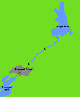
Owenbeg (Irish : An Abhainn Bheag, meaning "the little river") is a town in [[County Sligo Ireland]] in Ireland situated on the N59 national highway section between Ballina, County Mayo, and Sligo Town, County Sligo, near the junction of the road with R297. The name is an anglicisation of the Irish-language words abhainn beag, or "little river", after the river on which it is situated.

Irish language Goidelic (Gaelic) language spoken in Ireland and by Irish people

Irish is a member of the Goidelic (Gaelic) language branch of the Celtic languages originating in Ireland and historically spoken by the Irish people. Irish is spoken as a first language in substantial areas of counties Galway, Kerry, Cork and Donegal, smaller areas of Waterford, Mayo and Meath, and a few other locations, and as a second language by a larger group of non-habitual speakers across the country.

County Sligo County in the Republic of Ireland

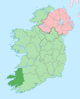
County Sligo is a county in Ireland. It is located in the Border Region and is part of the province of Connacht. Sligo is the administrative capital and largest town in the county. Sligo County Council is the local authority for the county. The population of the county is 65,535 according to the 2016 census, making it the 3rd most populated county in the province. It is noted for Benbulben Mountain, one of Ireland’s most distinctive natural landmarks.

Republic of Ireland Ireland, a country in north-western Europe, occupying 5/6 of the island of Ireland; succeeded the Irish Free State (1937)

Ireland, also known as the Republic of Ireland, is a country in north-western Europe occupying 26 of 32 counties of the island of Ireland. The capital and largest city is Dublin, which is located on the eastern side of the island. Around a third of the country's population of 4.8 million people resides in the greater Dublin area. The sovereign state shares its only land border with Northern Ireland, a part of the United Kingdom. It is otherwise surrounded by the Atlantic Ocean, with the Celtic Sea to the south, St George's Channel to the south-east, and the Irish Sea to the east. It is a unitary, parliamentary republic. The legislature, the Oireachtas, consists of a lower house, Dáil Éireann, an upper house, Seanad Éireann, and an elected President who serves as the largely ceremonial head of state, but with some important powers and duties. The head of government is the Taoiseach, who is elected by the Dáil and appointed by the President; the Taoiseach in turn appoints other government ministers.

Owenbeg is located at Latitude 54.2336 and Longitude -8.9467 at an altitude of 83 m above sea level. The namesake river of the town shares its name with, among others, Owenbeg Rivers in County Londonderry and County Kerry. [1]

Sea level Average level for the surface of the ocean at any given geographical position on the planetary surface

Mean sea level (MSL) is an average level of the surface of one or more of Earth's oceans from which heights such as elevation may be measured. MSL is a type of vertical datum – a standardised geodetic datum – that is used, for example, as a chart datum in cartography and marine navigation, or, in aviation, as the standard sea level at which atmospheric pressure is measured to calibrate altitude and, consequently, aircraft flight levels. A common and relatively straightforward mean sea-level standard is the midpoint between a mean low and mean high tide at a particular location.

County Londonderry Place in Northern Ireland, United Kingdom

County Londonderry, also known as County Derry, is one of the six counties of Northern Ireland. Prior to the partition of Ireland, it was one of the counties of the Kingdom of Ireland from 1613 onward and then of the United Kingdom after the Acts of Union 1800. Adjoining the north-west shore of Lough Neagh, the county covers an area of 2,074 km² and today has a population of about 247,132.

County Kerry County in the Republic of Ireland

County Kerry is a county in Ireland. It is located in the South-West Region and forms part of the province of Munster. It is named after the Ciarraige who lived in part of the present county. Kerry County Council is the local authority for the county and Tralee serves as the county town. The population of the county was 147,707 at the 2016 census.

Related Research Articles

Sligo Town in Connacht, Ireland

Sligo is a coastal seaport and the county town of County Sligo, Ireland, within the western province of Connacht. With a population of approximately 20,000 in 2016, it is the second largest urban centre in the West of Ireland, with only Galway being larger. The Sligo Borough District constitutes 61% (38,581) of the county's population of 63,000.

Enniscrone Town in Connacht, Ireland

Enniscrone – also spelt Inniscrone and officially named Inishcrone – is a small seaside town in County Sligo, Ireland. Its sandy beach, tourist campsite, and golf course all attract a large number of visitors. The Enniscrone area includes the localities of Muckduff, Lacken, Lacknaslevia, Frankford, Carrowhubbock South and Carrowhubbock North. Recently, local David McGowan has begun construction of a "glamping" village, with the main focus being the Boeing 767 he bought to convert into accommodation.

Ballinhassig Village in Munster, Ireland

Ballinhassig is a village in County Cork, Ireland, situated 10.6 km south of Cork City just off the N71 Bandon road and near the source of the River Owenabue.

River Avoca river in County Wicklow, Ireland

The Avoca is a river in County Wicklow, Ireland. It is contained completely within the county. Its length is 35 miles (56.3 km).

River Bandon river in County Cork, Ireland

The River Bandon is a river in County Cork, Ireland. It rises at Nowen Hill, to the north of Drimoleague. The river then flows to Dunmanway, before turning eastward towards the twin villages of Ballineen and Enniskean. It then makes its way through the centre of Bandon town, and on to Innishannon and Kilmacsimon, before draining into Kinsale Harbour on Ireland's south coast.

River Erne river in Ireland and the UK

The River Erne in the northwest of the island of Ireland, is the second-longest river in Ulster flowing through Northern Ireland and the Republic of Ireland. It rises on the east shoulder of Slieve Glah mountain three miles south of Cavan in County Cavan, Republic of Ireland, and flows 80 miles (129 km) through Lough Gowna, Lough Oughter and Upper and Lower Lough Erne, County Fermanagh, Northern Ireland, to the sea at Ballyshannon, County Donegal back in the Republic. For 30 miles from Crossdoney in County Cavan to Enniskillen in County Fermanagh, it is difficult to distinguish the river as it winds its way through interconnected loughs or parts of loughs nestling among the drumlin hills of Cavan and south Fermanagh. The river is 120 kilometres long and is used for fly fishing for trout and salmon, with a number of fisheries along both the river itself and its tributaries. The town of Enniskillen is mostly situated on an island in the river, between Upper and Lower Lough Erne. It is linked to the River Shannon by the Shannon–Erne Waterway. The total catchment area of the River Erne is 4,372 km2. The long-term average flow rate of the River Erne is 101.7 cubic metres per second (m3/s)

Easky Village in Connacht, Ireland

Easky or Easkey is a village in County Sligo, Ireland. It is on the Atlantic coast, 26 miles from Sligo and 15 miles from Ballina, County Mayo. The village name derives from the Irish language term for fish ("iasc") and "Iascaigh" literally means "abounding in fish", due to the Easky River that lies adjacent to the village itself. Easky, as a parish, was originally called "Imleach Iseal". The area is a popular tourist destination due to its scenery and water sport options. Easky is a designated area on Ireland's Wild Atlantic Way tourist route.

Riverstown Village in Connacht, Ireland

Riverstown, historically called Ballyederdaowen, is a village in County Sligo, Ireland. It is located at a bridging point of the River Unshin (Arrow), about 19 km south of Sligo town and 4 km east of the N4 road.

Dowra Village in Ireland

Dowra is a village in northwest County Cavan, Ireland. Nested to a valley on Lough Allen, it is the first village on, and marks the most uppermost navigable point of, the River Shannon. On one side of its bridge is County Cavan; on the other is County Leitrim. The nucleus of the village is situated in the Cavan side. It is located on the junction of the R200 and R207 regional roads.

Hazelwood, County Sligo

Hazelwood is located just over 2 miles outside the town of Sligo in northwest Ireland, in the parish of Calry. It is the setting for W.B.Yeats's The Song of Wandering Aengus.

River Garavogue river in Ireland

The Garavogue is a river located in County Sligo, Ireland. From Lough Gill, it winds its way through Sligo town and into Sligo Bay. The river has a large estuary with a shipping channel capable of taking ships up to 10,000 tons, but now fallen into disuse and used mainly by smaller pleasure craft. The River Garavogue is 31.5 miles (50.7 km) long.

Sligo University Hospital is an acute general hospital serving the northwest of Ireland. It is situated in the town of Sligo. It is part of the Saolta University Hospital Group, within the HSE.

Roman Catholic Diocese of Elphin diocese of the Catholic Church

The Diocese of Elphin is a Roman Catholic diocese in the western part of Ireland. It is in the Metropolitan Province of Tuam and is subject to the Metropolitan Archdiocese of Tuam. The current Bishop is Kevin Doran who was appointed in 2014.

Sooey, meaning abounding in the plant Sorrel, is a village in County Sligo, Republic of Ireland. The village is situated near Riverstown, on the R284 road which runs between Sligo and Leitrim village in County Leitrim.

Castlelyons Village in Munster, Ireland

Castlelyons is a small village in the east of County Cork, Ireland. It is also a civil parish in the barony of Barrymore. The name is derived from a stronghold of the Uí Liatháin - an early medieval kingdom. It is situated 6 km (3.7 mi) south of Fermoy. In the 2002 census it recorded a population of 211.

River Eske river in Ireland

The River Eske is a river in the northwest of Ireland in County Donegal in Ulster, beginning at Lough Eske in southeast County Donegal before flowing mainly westwards to the town of Donegal and into the Atlantic via Donegal Bay.

Ballisodare River river in Ireland

The Ballisodare River is a river in Ireland, flowing through County Sligo.

River Erriff

The River Erriff is a river in Ireland, flowing through County Mayo. A spate river, it is characterised by lively streams and deep fish-holding pools..Near the mouth of the river a spectacular wallfall called Aasleagh Falls is situated.

Owenmore River (County Sligo)

The Owenmore River is a river in County Sligo, Ireland. Its source is in the far south of Sligo, near Gorteen and Lough Gara, from which it runs for 52.3 km to its juncture with the Unshin River near Collooney to form the Ballisodare River. Its catchment covers 655 square kilometres (253 sq mi), predominantly located in Sligo but with small parts in County Mayo and County Roscommon. The catchment is underlain by limestone, and the total length of all the rivers in the Greater Owenmore Basin Area is 639 kilometres (397 mi). There are approximately 1,470 hectares (5.7 sq mi) of lakes in the catchment, with Lough Arrow comprising most of this.

References

  1. Cassells Gazetteer of Great Britain and Ireland, London 1900

See also

Coordinates: 54°14′01″N8°56′48″W / 54.23361°N 8.94667°W / 54.23361; -8.94667

Geographic coordinate system Coordinate system

A geographic coordinate system is a coordinate system that enables every location on Earth to be specified by a set of numbers, letters or symbols. The coordinates are often chosen such that one of the numbers represents a vertical position and two or three of the numbers represent a horizontal position; alternatively, a geographic position may be expressed in a combined three-dimensional Cartesian vector. A common choice of coordinates is latitude, longitude and elevation. To specify a location on a plane requires a map projection.