
Iganga is a town in the Eastern Region of Uganda. It is the main municipal, administrative, and commercial center of Iganga District, and the district headquarters are located there.

NGC 7380 is an open cluster discovered by Caroline Herschel in 1787. William Herschel included his sister's discovery in his catalog, and labelled it H VIII.77. It is also known as 142 in the 1959 Sharpless catalog (Sh2-142). This reasonably large nebula is located in Cepheus. It is extremely difficult to observe visually, usually requiring very dark skies and an O-III filter.
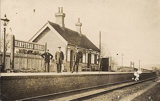
Hampstead Norris railway station was a station on the Didcot, Newbury and Southampton Railway in England. It served the village of Hampstead Norreys in Berkshire. The station closed in 1962.
Hallaryd is a locality situated in Älmhult Municipality, Kronoberg County, Sweden.
Pulan District is one of eleven districts of the province Santa Cruz in Peru.
Ebi Station is a train station in Kofu, Tottori Prefecture, Japan.
Psary-Lechawa is a village in the administrative district of Gmina Wolbórz, within Piotrków County, Łódź Voivodeship, in central Poland.

Marianów is a village in the administrative district of Gmina Biała Rawska, within Rawa County, Łódź Voivodeship, in central Poland. It lies approximately 5 kilometres (3 mi) north-west of Biała Rawska, 14 km (9 mi) north-east of Rawa Mazowiecka, and 66 km (41 mi) east of the regional capital Łódź.
Stanisławów is a village in the administrative district of Gmina Biała Rawska, within Rawa County, Łódź Voivodeship, in central Poland.
Zygmuntów is a village in the administrative district of Gmina Fałków, within Końskie County, Świętokrzyskie Voivodeship, in south-central Poland.
Janówek is a village in the administrative district of Gmina Mszczonów, within Żyrardów County, Masovian Voivodeship, in east-central Poland.
Małachowszczyzna is a village in the administrative district of Gmina Mszczonów, within Żyrardów County, Masovian Voivodeship, in east-central Poland.
Nowe Poręby is a village in the administrative district of Gmina Mszczonów, within Żyrardów County, Masovian Voivodeship, in east-central Poland.
Olszewek is a village in the administrative district of Gmina Mszczonów, within Żyrardów County, Masovian Voivodeship, in east-central Poland.
Wymysłów is a village in the administrative district of Gmina Mszczonów, within Żyrardów County, Masovian Voivodeship, in east-central Poland.

Nogale Manor is a manor house in Neo-Classicism style in Ārlava parish, in the Talsi municipality of the historical region of Courland, western Latvia. It was built around 1880 according to the project by the architect T. Seiler.

The Diocletian Aqueduct is an ancient Roman aqueduct near Split, Croatia constructed during the Roman Empire to supply water to the Palace of Emperor Diocletian.
Vintervegen is a glacier in Oscar II Land at Spitsbergen, Svalbard. It has a length of about 7.5 kilometers (4.7 mi). The glacier borders to the mountain of Klampen, merges with Osbornebreen and other glaciers, and the merged glacier stream debouches into the head of St. Jonsfjorden.

Colney Heath Local Nature Reserve is a 22.5 hectare Local Nature Reserve in Colney Heath in Hertfordshire. It is owned by St Albans City Council and managed by Colney Heath Parish Council. The site was acquired in the 1950s and 1960s, and it is a Hertfordshire Heritage Site.

Tiger and Turtle – Magic Mountain is an art installation and landmark in Angerpark, Duisburg, Germany, built in 2011. It is 21 meters tall, made of galvanized steel, and cost two million Euros to build. It was designed by Ulrich Genth and Heike Mutter. It resembles a roller coaster, but it is a walkway with stairs. Its vertical loop continues the walkway and stairs, but it is unwalkable and is blocked off. In 2013, Tiger and Turtle – Magic Mountain was ranked as #6 on HuffPost's list of Most Extreme Staircases.


