The A194 road is a road in Tyne and Wear, England. It runs northeast from its start at junction 65 of the A1(M) near Washington, and the first 3 miles (4.8 km) are motorway standard, designated the A194(M). There are intermediate junctions with the A182 and the A195 before the motorway section ends at the A184 junction. The junctions were unnumbered until 2013 when they were designated J1 to J3.
Maimecha River, also known as Medvezh'ya River, is a river in Evenk and Taymyr Autonomous Okrugs of Krasnoyarsk Krai in Russia, right composite of the Kheta River. The length of the river is 650 kilometres (400 mi). The area of its drainage basin is 26,500 square kilometres (10,200 sq mi).

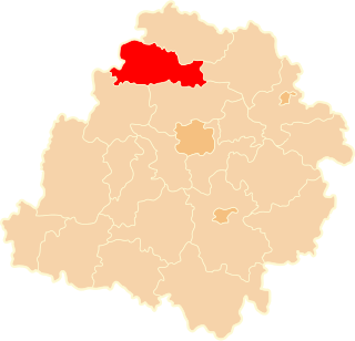
The Archdiocese of Częstochowa is an archdiocese located in the city of Częstochowa in Poland.
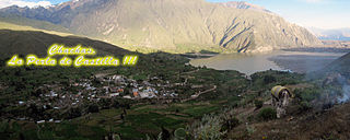
Chachas District is one of fourteen districts of the province Castilla in Peru.
Łążyn is a village in the administrative district of Gmina Zławieś Wielka, within Toruń County, Kuyavian-Pomeranian Voivodeship, in north-central Poland.
Golska Huta is a village in the administrative district of Gmina Lubień Kujawski, within Włocławek County, Kuyavian-Pomeranian Voivodeship, in north-central Poland.
Sławęcin is a village in the administrative district of Gmina Lubień Kujawski, within Włocławek County, Kuyavian-Pomeranian Voivodeship, in north-central Poland.
Wiktorowo is a village in the administrative district of Gmina Lubień Kujawski, within Włocławek County, Kuyavian-Pomeranian Voivodeship, in north-central Poland.
The Roman Catholic Diocese of Bongaigaon is a diocese located in the city of Bongaigaon in the Ecclesiastical province of Guwahati in India.

Antoninów is a village in the administrative district of Gmina Gostynin, within Gostynin County, Masovian Voivodeship, in east-central Poland. It lies approximately 11 kilometres (7 mi) north-east of Gostynin and 105 km (65 mi) west of Warsaw.
Białotarsk is a village in the administrative district of Gmina Gostynin, within Gostynin County, Masovian Voivodeship, in east-central Poland. It lies approximately 11 kilometres (7 mi) west of Gostynin and 118 km (73 mi) west of Warsaw.
Bolesławów is a village in the administrative district of Gmina Gostynin, within Gostynin County, Masovian Voivodeship, in east-central Poland. It lies approximately 6 kilometres (4 mi) north-east of Gostynin and 104 km (65 mi) west of Warsaw.
Górki Drugie is a village in the administrative district of Gmina Gostynin, within Gostynin County, Masovian Voivodeship, in east-central Poland.
Leśniewice is a village in the administrative district of Gmina Gostynin, within Gostynin County, Masovian Voivodeship, in east-central Poland. It lies approximately 4 kilometres (2 mi) south of Gostynin and 107 km (66 mi) west of Warsaw.
Lucień is a village in the administrative district of Gmina Gostynin, within Gostynin County, Masovian Voivodeship, in east-central Poland. The village has a population of 24.
Sałki is a village in the administrative district of Gmina Gostynin, within Gostynin County, Masovian Voivodeship, in east-central Poland.
Lenarty is a village in the administrative district of Gmina Olecko, within Olecko County, Warmian-Masurian Voivodeship, in northern Poland. It lies approximately 12 kilometres (7 mi) north of Olecko and 138 km (86 mi) east of the regional capital Olsztyn.
Kozluk is a village located in the Zvornik Municipality, Bosnia and Herzegovina. Kozluk is an ethnic Bosniak majority village.

The Käthe Kollwitz Museum in Berlin owns one of the largest collections of works by the German artist Käthe Kollwitz (1867–1945). Kollwitz lived and worked in Berlin's Prenzlauer Berg for over 50 years.
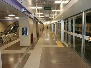
Istria is a station on Line 5 of Milan Metro.