PP-format

Last updated

The PP-format (Post Processing Format) is a proprietary file format for meteorological data developed by the Met Office, the United Kingdom's national weather service. [1]

A file format is a standard way that information is encoded for storage in a computer file. It specifies how bits are used to encode information in a digital storage medium. File formats may be either proprietary or free and may be either unpublished or open.

Met Office United Kingdoms national weather service

The Met Office is the United Kingdom's national weather service. It is an executive agency and trading fund of the Department for Business, Energy and Industrial Strategy led by CEO, Penelope Endersby, who took on the role as Chief Executive in December 2018, the first woman to do so. The Met Office makes meteorological predictions across all timescales from weather forecasts to climate change.

United Kingdom Country in Europe

The United Kingdom (UK), officially the United Kingdom of Great Britain and Northern Ireland, and sometimes referred to as Britain, is a sovereign country located off the north-western coast of the European mainland. The United Kingdom includes the island of Great Britain, the north-eastern part of the island of Ireland, and many smaller islands. Northern Ireland is the only part of the United Kingdom that shares a land border with another sovereign state, the Republic of Ireland. Apart from this land border, the United Kingdom is surrounded by the Atlantic Ocean, with the North Sea to the east, the English Channel to the south and the Celtic Sea to the south-west, giving it the 12th-longest coastline in the world. The Irish Sea lies between Great Britain and Ireland. With an area of 242,500 square kilometres (93,600 sq mi), the United Kingdom is the 78th-largest sovereign state in the world. It is also the 22nd-most populous country, with an estimated 66.0 million inhabitants in 2017.

Simulations of the weather are performed by the Met Office's Unified Model, which can be used for Numerical Weather Prediction or Climatology, and data is collected. This data is usually meteorological in nature and may include averaged data for parameters like global surface temperatures or accumulations of rainfall for locations inside the model, though the Unified Model is capable of outputting many sophisticated diagnostics to PP-format. These files are binary streams, structured in a proprietary file format which can then be processed and transformed into other, more portable, formats. The main reason for using such a format is to increase the rate at which data can be written from the model to disk, a major consideration when running a simulation that must be timely and efficient.

Weather Short-term state of the atmosphere

Weather is the state of the atmosphere, describing for example the degree to which it is hot or cold, wet or dry, calm or stormy, clear or cloudy. Most weather phenomena occur in the lowest level of the atmosphere, the troposphere, just below the stratosphere. Weather refers to day-to-day temperature and precipitation activity, whereas climate is the term for the averaging of atmospheric conditions over longer periods of time. When used without qualification, "weather" is generally understood to mean the weather of Earth.

The Unified Model is a Numerical Weather Prediction and climate modeling software suite originally developed by the United Kingdom Met Office, and now both used and further developed by many weather-forecasting agencies around the world. The Unified Model gets its name because a single model is used across a range of both timescales and spatial scales. The models are grid-point based, rather than wave based, and are run on a variety of supercomputers around the world. The Unified Model atmosphere can be coupled to a number of ocean models. At the Met Office it is used for the main suite of Global Model, North Atlantic and Europe model (NAE) and a high-resolution UK model (UKV), in addition to a variety of Crisis Area Models and other models that can be run on demand. Similar Unified Model suites with global and regional domains are used by many other national or military weather agencies around the world for operational forecasting.

Climatology The scientific study of climate, defined as weather conditions averaged over a period of time

Climatology or climate science is the scientific study of climate, scientifically defined as weather conditions averaged over a period of time. This modern field of study is regarded as a branch of the atmospheric sciences and a subfield of physical geography, which is one of the Earth sciences. Climatology now includes aspects of oceanography and biogeochemistry. Basic knowledge of climate can be used within shorter term weather forecasting using analog techniques such as the El Niño–Southern Oscillation (ENSO), the Madden–Julian oscillation (MJO), the North Atlantic oscillation (NAO), the Northern Annular Mode (NAM) which is also known as the Arctic oscillation (AO), the Northern Pacific (NP) Index, the Pacific decadal oscillation (PDO), and the Interdecadal Pacific Oscillation (IPO). Climate models are used for a variety of purposes from study of the dynamics of the weather and climate system to projections of future climate. Weather is known as the condition of the atmosphere over a period of time, while climate has to do with the atmospheric condition over an extended to indefinite period of time.
Related Research Articles

Meteorology Interdisciplinary scientific study of the atmosphere focusing on weather forecasting

Meteorology is a branch of the atmospheric sciences which includes atmospheric chemistry and atmospheric physics, with a major focus on weather forecasting. The study of meteorology dates back millennia, though significant progress in meteorology did not occur until the 18th century. The 19th century saw modest progress in the field after weather observation networks were formed across broad regions. Prior attempts at prediction of weather depended on historical data. It was not until after the elucidation of the laws of physics and more particularly, the development of the computer, allowing for the automated solution of a great many equations that model the weather, in the latter half of the 20th century that significant breakthroughs in weather forecasting were achieved. An important domain of weather forecasting is marine weather forecasting as it relates to maritime and coastal safety, in which weather effects also include atmospheric interactions with large bodies of water.

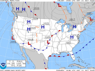
Surface weather analysis

Surface weather analysis is a special type of weather map that provides a view of weather elements over a geographical area at a specified time based on information from ground-based weather stations.

Weather forecasting application of science and technology to predict the conditions of the atmosphere for a given location and time

Weather forecasting is the application of science and technology to predict the conditions of the atmosphere for a given location and time. People have attempted to predict the weather informally for millennia and formally since the 19th century. Weather forecasts are made by collecting quantitative data about the current state of the atmosphere at a given place and using meteorology to project how the atmosphere will change.

SPSS Statistical analysis software

SPSS Statistics is a software package used for interactive, or batched, statistical analysis. Long produced by SPSS Inc., it was acquired by IBM in 2009. The current versions (2015) are named IBM SPSS Statistics.

Weather station set of sensors that record and provide physical measurements and meteorological parameters

A weather station is a facility, either on land or sea, with instruments and equipment for measuring atmospheric conditions to provide information for weather forecasts and to study the weather and climate. The measurements taken include temperature, atmospheric pressure, humidity, wind speed, wind direction, and precipitation amounts. Wind measurements are taken with as few other obstructions as possible, while temperature and humidity measurements are kept free from direct solar radiation, or insolation. Manual observations are taken at least once daily, while automated measurements are taken at least once an hour. Weather conditions out at sea are taken by ships and buoys, which measure slightly different meteorological quantities such as sea surface temperature (SST), wave height, and wave period. Drifting weather buoys outnumber their moored versions by a significant amount.

National Weather Service United States weather agency

The National Weather Service (NWS) is an agency of the United States federal government that is tasked with providing weather forecasts, warnings of hazardous weather, and other weather-related products to organizations and the public for the purposes of protection, safety, and general information. It is a part of the National Oceanic and Atmospheric Administration (NOAA) branch of the Department of Commerce, and is headquartered in Silver Spring, Maryland, within the Washington metropolitan area. The agency was known as the United States Weather Bureau from 1890 until it adopted its current name in 1970.

Computer simulation simulation, run on a single computer, or a network of computers, to reproduce behavior of a system; modeling a real physical system in a computer

Computer simulation is the reproduction of the behavior of a system using a computer to simulate the outcomes of a mathematical model associated with said system. Since they allow to check the reliability of chosen mathematical models, computer simulations have become a useful tool for the mathematical modeling of many natural systems in physics, astrophysics, climatology, chemistry, biology and manufacturing, human systems in economics, psychology, social science, health care and engineering. Simulation of a system is represented as the running of the system's model. It can be used to explore and gain new insights into new technology and to estimate the performance of systems too complex for analytical solutions.

The High-level architecture (HLA) is a standard for distributed simulation, used when building a simulation for a larger purpose by combining (federating) several simulations. The standard was developed in the 90’s under the leadership of the US Department of Defense and was later transitioned to become an open international IEEE standard. It is a recommended standard within NATO through STANAG 4603. Today the HLA is used in a number of domains including defense and security and civilian applications. The architecture specifies the following components.

Numerical weather prediction uses mathematical models of the atmosphere and oceans to predict the weather based on current weather conditions

Numerical weather prediction (NWP) uses mathematical models of the atmosphere and oceans to predict the weather based on current weather conditions. Though first attempted in the 1920s, it was not until the advent of computer simulation in the 1950s that numerical weather predictions produced realistic results. A number of global and regional forecast models are run in different countries worldwide, using current weather observations relayed from radiosondes, weather satellites and other observing systems as inputs.

The Bureau of Meteorology (BOM) is an Executive Agency of the Australian Government responsible for providing weather services to Australia and surrounding areas. It was established in 1906 under the Meteorology Act, and brought together the state meteorological services that existed before then. The states officially transferred their weather recording responsibilities to the Bureau of Meteorology on 1 January 1908.

GRIB is a concise data format commonly used in meteorology to store historical and forecast weather data. It is standardized by the World Meteorological Organization's Commission for Basic Systems, known under number GRIB FM 92-IX, described in WMO Manual on Codes No.306. Currently there are three versions of GRIB. Version 0 was used to a limited extent by projects such as TOGA, and is no longer in operational use. The first edition is used operationally worldwide by most meteorological centers, for Numerical Weather Prediction output (NWP). A newer generation has been introduced, known as GRIB second edition, and data is slowly changing over to this format. Some of the second-generation GRIB are used for derived product distributed in Eumetcast of Meteosat Second Generation. Another example is the NAM model.

CAD data exchange is a modality of data exchange used to translate data between different Computer-aided design (CAD) authoring systems or between CAD and other downstream CAx systems.

Atmospheric model mathematical model based on the dynamical equations which govern atmospheric motions

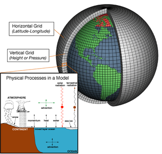
An atmospheric model is a mathematical model constructed around the full set of primitive dynamical equations which govern atmospheric motions. It can supplement these equations with parameterizations for turbulent diffusion, radiation, moist processes, heat exchange, soil, vegetation, surface water, the kinematic effects of terrain, and convection. Most atmospheric models are numerical, i.e. they discretize equations of motion. They can predict microscale phenomena such as tornadoes and boundary layer eddies, sub-microscale turbulent flow over buildings, as well as synoptic and global flows. The horizontal domain of a model is either global, covering the entire Earth, or regional (limited-area), covering only part of the Earth. The different types of models run are thermotropic, barotropic, hydrostatic, and nonhydrostatic. Some of the model types make assumptions about the atmosphere which lengthens the time steps used and increases computational speed.

The NAME atmospheric pollution dispersion model was first developed by the UK's Met Office in 1986 after the nuclear accident at Chernobyl, which demonstrated the need for a method that could predict the spread and deposition of radioactive gases or material released into the atmosphere.

Norwegian Meteorological Institute

The Norwegian Meteorological Institute, also known internationally as MET Norway, is Norway's national meteorological institute. It provides weather forecasts for civilian and military uses and conducts research in meteorology, oceanography and climatology. It is headquartered in Oslo and has offices and stations in other cities and places. It has around 500 full-time staff and was founded in 1866.

MOZART is a chemistry transport model (CTM) developed jointly by the (US) National Center for Atmospheric Research (NCAR), the Geophysical Fluid Dynamics Laboratory (GFDL), and the Max Planck Institute for Meteorology (MPI-Met) to simulate changes in ozone concentrations in the Earth's atmosphere. MOZART was designed to simulate tropospheric chemical and transport processes, but has been extended into the stratosphere and mesosphere. It can be driven by standard meteorological fields from, e.g.,

yEd

yEd is a general-purpose diagramming program with a multi-document interface.

The Navy Global Environmental Model (NAVGEM) is a global numerical weather prediction computer simulation run by the United States Navy's Fleet Numerical Meteorology and Oceanography Center. This mathematical model is run four times a day and produces weather forecasts. Along with the NWS's Global Forecast System, which runs out to 16 days, the ECMWF's Integrated Forecast System (IFS) and the CMC's Global Environmental Multiscale Model (GEM), both of which run out 10 days, and the UK Met Office's Unified Model, which runs out to 98 days, it is one of five synoptic scale medium-range models in general use.

References

  1. "PP file format". British Atmospheric Data Centre. Natural Environment Research Council . Retrieved 27 October 2016.