Pacific Slope

Last updated
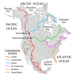
The Pacific Slope is west of the continental divide (red line) in North and Central America. NorthAmerica-WaterDivides.png
The Pacific Slope is west of the continental divide (red line) in North and Central America.

The Pacific Slope describes geographic regions in North American, Central American, and South American countries that are west of the continental divide and slope down to the Pacific Ocean. In North America, the Rocky Mountains mark the eastern border of the Pacific Slope. In Central and South America, the region is much narrower, confined by the Sierra Madre Occidental in Central America, [1] [2] and by the Andes in South America. [3] The phrase is still used today mostly for scientific purposes to refer to regions inhabited by specific species. [4] [5]

It was and is still occasionally used to describe the region in North America during the 19th century and the expansion of the Old West. It includes the states and territories west of the continental divide that runs down the Rocky Mountains in North America. This included the territories and the states that emerged from them, including California, Oregon Territory, Washington Territory, Nevada Territory, Idaho Territory, Colorado Territory, and Utah Territory. The region is drained by the Columbia, Sacramento, San Joaquin and Colorado River systems. [6] [7] In the United States, the Pacific-slope flycatcher takes its name from the region it inhabits.

In Central America, it includes the mountain and coastal regions west of the Continental Divide in Mexico and southern Guatemala, southwestern Honduras, western Nicaragua, and western/southwestern Costa Rica, and southern Panama. In Guatemala, the Pacific Slope region is a humid plain of fertile land divided into widespread plantations (fincas) that grow abundant crops including sugarcane, bananas, and rubber. [8] In Costa Rica, the Pacific Slope refers to the region west of the continental divide at Monteverde, Costa Rica. [9]

In South America, the Pacific Slope is the narrow region west of the highest points of the Andes, including western Colombia, central Ecuador, western and southwestern Peru, and eastern Chile.

Related Research Articles

<span class="mw-page-title-main">Continental Divide of the Americas</span> Principal hydrological divide of North and South America

The Continental Divide of the Americas is the principal, and largely mountainous, hydrological divide of the Americas. The Continental Divide extends from the Bering Strait to the Strait of Magellan, and separates the watersheds that drain into the Pacific Ocean from those river systems that drain into the Atlantic and Arctic Ocean, including those that drain into the Gulf of Mexico, the Caribbean Sea, and Hudson Bay.

<span class="mw-page-title-main">Mountain Time Zone</span> Time zone of North America

The Mountain Time Zone of North America keeps time by subtracting seven hours from Coordinated Universal Time (UTC) when standard time (UTC−07:00) is in effect, and by subtracting six hours during daylight saving time (UTC−06:00). The clock time in this zone is based on the mean solar time at the 105th meridian west of the Greenwich Observatory. In the United States, the exact specification for the location of time zones and the dividing lines between zones is set forth in the Code of Federal Regulations at 49 CFR 71.

<span class="mw-page-title-main">Classification of the Indigenous peoples of the Americas</span>

The classification of the Indigenous peoples of the Americas is based upon cultural regions, geography, and linguistics. Anthropologists have named various cultural regions, with fluid boundaries, that are generally agreed upon with some variation. These cultural regions are broadly based upon the locations of the Indigenous peoples of the Americas from early European and African contact beginning in the late 15th century. When Indigenous peoples have been forcibly removed by nation-states, they retain their original geographic classification. Some groups span multiple cultural regions.

<span class="mw-page-title-main">Northwestern United States</span> Geographical region of the United States

The Northwestern United States, also known as the American Northwest or simply the Northwest, is an informal geographic region of the United States. The region consistently includes the states of Oregon, Washington, Idaho, Montana and Wyoming. Some sources include Southeast Alaska in the Northwest. The related but distinct term "Pacific Northwest" generally excludes areas from the Rockies eastward, whereas the term "Inland Northwest" excludes areas west of the Cascades.

<span class="mw-page-title-main">UTC−07:00</span> Identifier for a time offset from UTC of −7

UTC−07:00 is an identifier for a time offset from UTC of −07:00. In North America, it is observed in the Mountain Time Zone during standard time, and in the Pacific Time Zone during the other eight months. Some locations use it year-round.

<span class="mw-page-title-main">UTC−06:00</span> Identifier for a time offset from UTC of −6

UTC−06:00 is an identifier for a time offset from UTC of −06:00. In North America, it is observed in the Central Time Zone during standard time, and in the Mountain Time Zone during the other eight months. Several Latin American countries and a few other places use it year-round.

<span class="mw-page-title-main">North American Cordillera</span> North American portion of the American Cordillera mountain chain

The North American Cordillera, sometimes also called the Western Cordillera of North America, the Western Cordillera, or the Pacific Cordillera, is the North American portion of the American Cordillera, the mountain chain system along the Pacific coast of the Americas. The North American Cordillera covers an extensive area of mountain ranges, intermontane basins, and plateaus in Western and Northwestern Canada, Western United States, and Mexico, including much of the territory west of the Great Plains.

<span class="mw-page-title-main">Americas (terminology)</span> Geographical term

The Americas, also known as America, are lands of the Western Hemisphere, composed of numerous entities and regions variably defined by geography, politics, and culture.

<i>Hackelia</i> Genus of flowering plants in the borage family Boraginaceae

Hackelia (stickseeds) is a genus of plants in the borage family, Boraginaceae. It includes 54 species found in North America, western South America, temperate Eurasia, and Australia. 12 species are native to California.

<span class="mw-page-title-main">Geography of North America</span>

North America is the third largest continent, and is also a portion of the third largest supercontinent if North and South America are combined into the Americas and Africa, Europe, and Asia are considered to be part of one supercontinent called Afro-Eurasia. With an estimated population of 580 million and an area of 24,709,000 km2 (9,540,000 mi2), the northernmost of the two continents of the Western Hemisphere is bounded by the Pacific Ocean on the west; the Atlantic Ocean on the east; the Caribbean Sea on the south; and the Arctic Ocean on the north.

<i>Muhlenbergia</i> Genus of plants

Muhlenbergia is a genus of plants in the grass family.

The Central America bioregion is a biogeographic region comprising southern Mexico and Central America.

<span class="mw-page-title-main">Continental divide</span> Drainage divide on a continent

A continental divide is a drainage divide on a continent such that the drainage basin on one side of the divide feeds into one ocean or sea, and the basin on the other side either feeds into a different ocean or sea, or else is endorheic, not connected to the open sea. Every continent on earth except Antarctica has at least one continental drainage divide; islands, even small ones like Killiniq Island on the Labrador Sea in Canada, may also host part of a continental divide or have their own island-spanning divide. The endpoints of a continental divide may be coastlines of gulfs, seas or oceans, the boundary of an endorheic basin, or another continental divide. One case, the Great Basin Divide, is a closed loop around an endorheic basin. The endpoints where a continental divide meets the coast are not always definite since the exact border between adjacent bodies of water is usually not clearly defined. The International Hydrographic Organization's publication Limits of Oceans and Seas defines exact boundaries of oceans, but it is not universally recognized. Where a continental divide meets an endorheic basin, such as the Great Divide Basin of Wyoming, the continental divide splits and encircles the basin. Where two divides intersect, they form a triple divide, or a tripoint, a junction where three watersheds meet.

<span class="mw-page-title-main">Watersheds of North America</span>

Watersheds of North America are large drainage basins which drain to separate oceans, seas, gulfs, or endorheic basins. There are six generally recognized hydrological continental divides which divide the continent into seven principal drainage basins spanning three oceans and one endorheic basin. The basins are the Atlantic Seaboard basin, the Gulf of Mexico basin, the Great Lakes-St. Lawrence basin, the Pacific basin, the Arctic basin, the Hudson Bay basin, and the Great Basin. Together, the principal basins span the continent with the exception of numerous smaller endorheic basins.

<span class="mw-page-title-main">Mountain states</span> Region of the United States

The Mountain states form one of the nine geographic divisions of the United States that are officially recognized by the United States Census Bureau. It is a subregion of the Western United States.

<span class="mw-page-title-main">Geology of North America</span>

The geology of North America is a subject of regional geology and covers the North American continent, the third-largest in the world. Geologic units and processes are investigated on a large scale to reach a synthesized picture of the geological development of the continent.

Lists of mountains can be organized by continent and more specifically by country and province/state:

References

  1. Browne, John Ross (1869). Resources of the Pacific Slope. San Francisco: H. H. Bancroft and Company.
  2. Richard, Jerome S. (February 1908). "Meteorology on the Pacific Slope". 16. Popular Astronomy: 92–98.{{cite journal}}: Cite journal requires |journal= (help)
  3. Leibel, Wayne. "South America - A Continent of Extreme Contrasts". Archived from the original on 2011-07-11.
  4. "The Angiosperm Phylogeny Group. An ordinal classification for the families of flowering plants". The Cutting Edge. VI (1). Missouri Botanical Garden: 531–553. January 1999.
  5. Margarita Caso; Charlotte González-Abraham; Exequiel Ezcurra (May 17, 2007). "Divergent ecological effects of oceanographic anomalies on terrestrial ecosystems of the Mexican Pacific coast". Albuquerque, NM: University of New Mexico. Archived from the original on September 24, 2015.{{cite journal}}: Cite journal requires |journal= (help)
  6. Rivers of the Pacific Slope (film). Coronet Instructional Films. 1947. Archived from the original on 2016-02-05.
  7. Pomeroy, Earl (2003). The Pacific Slope: a History of California, Oregon, Washington, Idaho, Utah, and Nevada. Reno: University of Nevada Press. p. 488. ISBN   978-0-87417-518-9.
  8. "Map of Pacific Slope". Archived from the original on 2012-07-16.
  9. Savage, Jay Mathers. (2002). The Amphibians and Reptiles of Costa Rica : a Herpetofauna Between Two Continents, Between Two Seas . Chicago: University of Chicago Press. p. 954. ISBN   978-0-226-73537-5.