


Page Street is a street in Pimlico, in the City of Westminster, that runs from Regency Street in the west to the junction of John Islip Street and Dean Ryle Street in the east, parallel with Horseferry Road. It is crossed midway by Marsham Street.
Page Street is a street in Pimlico, in the City of Westminster, that runs from Regency Street in the west to the junction of John Islip Street and Dean Ryle Street in the east, parallel with Horseferry Road. It is crossed midway by Marsham Street.
Though mostly undeveloped riverine marsh until the late eighteenth century, as evidenced by Horwood's map of 1792, [1] development was rapid in the nineteenth and the area became a notorious slum. On the night of 6 January 1928 much of the area flooded with loss of life, and later that year the Westminster Medical Officer of Health declared a Clearance Area to remove the slums and improve drainage.
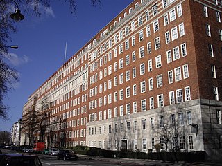
The street is notable for its social housing blocks. These are of two phases. The first, facing Regency Street and Page Street were commenced in 1902 and were considered of sufficient significance for the Prince of Wales to ceremonially lay the foundation stone in 1903. They are of red brick, similar in design to the nearby Pimlico Estate developed by the London County Council and the architects were Nathan S. Joseph and Charles James Smithem.
The second phase were designed by Sir Edwin Lutyens who was commissioned as consultant to the Grosvenor Estate, freeholder of the land, who granted a 999-year lease to Westminster and donated £120,000 towards the cost, provided the site was used for "housing for the working class," as part of the Westminster Housing Scheme. [2] [3] The flats have a conventional tenement plan and have striking and unusual chess-board facades of rectangles in buff-grey brick and rendered panels, covering the entirety of their outer facades. Accessed by balconies to the courtyard elevations, in the manner of much social housing of the period, the blocks were built in 1928–30 and front much of the western end of Page Street. The U-shaped internal courtyards face Page Street on the N side but are turned away from the street on the S side. The courtyards are narrower than most of those of London County Council blocks of the period, something which was partly mitigated by the partial demolition of Tothill and Rogers Houses in about 1970, due to war damage, which created a recreational space. As a result of this partial demolition the remaining Lutyens blocks and their lodges and gates were all Listed as early as 1970, when protection of social housing scheme was highly unusual. The landscaped areas are entered through wrought iron gates beside classical pavilion lodges, in typical Lutyens style; the lodges are in Portland stone with grey-buff brick under pyramidal roofs and were formerly small shops and a management office, but are now in a variety of uses. [4] The estate combines an unusual mixture of balcony access tenement architecture and the Lutyens detailing more often associated with the architect's country house architecture. It was Lutyen's only social housing design. [5]
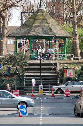
The former Westminster Hospital Nurses Home is located in the street. At the eastern end on the north side is St John's Gardens.
The Paviours Arms public house with its Art Deco interior was located in Neville House until both were demolished in 2003. [6]
Page Street was designated Westminster's 56th conservation area in 2010. [7]

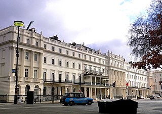
Pimlico is an area of Central London in the City of Westminster, built as a southern extension to neighbouring Belgravia. It is known for its garden squares and distinctive Regency architecture. Pimlico is demarcated to the north by Victoria Station, by the River Thames to the south, Vauxhall Bridge Road to the east and the former Grosvenor Canal to the west. At its heart is a grid of residential streets laid down by the planner Thomas Cubitt, beginning in 1825 and now protected as the Pimlico Conservation Area. The most prestigious are those on garden squares, with buildings decreasing in grandeur away from St George's Square, Warwick Square, Eccleston Square and the main thoroughfares of Belgrave Road and St. George's Drive. Additions have included the pre–World War II Dolphin Square and the Churchill Gardens and Lillington and Longmoore Gardens estates, now conservation areas in their own right. The area has over 350 Grade II listed buildings and several Grade II* listed churches. At the western edge of Pimlico, on the borders of Chelsea, Pimlico Road has become known in recent years for its interiors and design stores.
Millbank is an area of central London in the City of Westminster. Millbank is located by the River Thames, east of Pimlico and south of Westminster. Millbank is known as the location of major government offices, Burberry headquarters, the Millbank Tower and prominent art institutions such as Tate Britain and the Chelsea College of Art and Design.

An apartment, flat, or unit is a self-contained housing unit that occupies part of a building, generally on a single storey. There are many names for these overall buildings. The housing tenure of apartments also varies considerably, from large-scale public housing, to owner occupancy within what is legally a condominium or leasehold, to tenants renting from a private landlord.

Urban renewal is a program of land redevelopment often used to address urban decay in cities. Urban renewal involves the clearing out of blighted areas in inner cities in favour of new housing, businesses, and other developments.
Dolphin Square is an estate of private flats with some ground floor business units near the River Thames in Pimlico, Westminster, London built between 1935 and 1937. Until the building of Highbury Square, it was the most developed garden square in London built as private housing. At one time, it was home to more than 70 MPs and at least 10 Lords.

A tenement is a type of building shared by multiple dwellings, typically with flats or apartments on each floor and with shared entrance stairway access. They are common on the British Isles, particularly in Scotland. In the medieval Old Town, in Edinburgh, tenements were developed with each apartment treated as a separate house, built on top of each other. Over hundreds of years, custom grew to become law concerning maintenance and repairs, as first formally discussed in Stair's 1681 writings on Scots property law. In Scotland, these are now governed by the Tenements Act, which replaced the old Law of the Tenement and created a new system of common ownership and procedures concerning repairs and maintenance of tenements. Tenements with one- or two-room flats provided popular rented accommodation for workers, but in some inner-city areas, overcrowding and maintenance problems led to shanty towns, which have been cleared and redeveloped. In more affluent areas, tenement flats form spacious privately owned houses, some with up to six bedrooms, which continue to be desirable properties.
Grosvenor Group Limited is an internationally diversified property group, which traces its origins to 1677 and has its headquarters in London, England. It has a global reach, now in 62 international cities, with offices in 14 of them, operated on behalf of its owners, the Duke of Westminster and his family. It has four regional development and investment businesses and a portfolio of indirect investments. Its sectors include residential, office, retail, industrial, along with hotels.

The Golden Triangle is a wedge-shaped area within the southwestern suburbs of Norwich, United Kingdom. The base of the Triangle is at the Colman Road stretch of the outer ring road, which is one mile southwest of the city's inner ring, with the other two sides – Earlham Road and Newmarket Road – pointing into the city centre. The Unthank Road runs down the middle, forming the backbone and main shopping area of the Triangle. The Golden Triangle's terraces house professionals, families and many students from the nearby University of East Anglia; its friendly atmosphere has resulted in the Golden Triangle being dubbed the Norwich version of London's Notting Hill.

Victoria is an area of Central London in the City of Westminster. It is named after Victoria Station, which is a major transport hub. The station was named after the nearby Victoria Street, opened 1851.

London's architectural heritage involves many architectural styles from different historical periods. London's architectural eclecticism stems from its long history, continual redevelopment, destruction by the Great Fire of London and The Blitz, and state recognition of private property rights which have limited large-scale state planning. This sets London apart from other European capitals such as Paris and Rome which are more architecturally homogeneous. London's architecture ranges from the Romanesque central keep of The Tower of London, the great Gothic church of Westminster Abbey, the Palladian royal residence Queen's House, Christopher Wren's Baroque masterpiece St Paul's Cathedral, the High Victorian Gothic of The Palace of Westminster, the industrial Art Deco of Battersea Power Station, the post-war Modernism of The Barbican Estate and the Postmodern skyscraper 30 St Mary Axe 'The Gherkin'.
The Boundary Estate is a housing development in the London Borough of Tower Hamlets, in the East End of London.
Detmar Jellings Blow was a British architect of the early 20th century, who designed principally in the arts and crafts style. His clients belonged chiefly to the British aristocracy, and later he became estates manager to the Duke of Westminster.

Churchill Gardens is a large housing estate in the Pimlico area of Westminster, London. The estate was developed between 1946 and 1962 to a design by the architects Powell and Moya, replacing Victorian terraced houses extensively damaged during the Blitz.

St James the Less is a Church of England parish church in Pimlico, Westminster, built in 1858–61 by George Edmund Street in the Gothic Revival style. A Grade I listed building, it has been described as "one of the finest Gothic Revival churches anywhere". The church was constructed predominantly in brick with embellishments from other types of stone. Its most prominent external feature is its free-standing Italian-style tower, while its interior incorporates design themes which Street observed in medieval Gothic buildings in continental Europe.
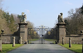
Belgrave is a historic village in Cheshire, England. The area is part of the estates owned the Dukes of Westminster who have their seat at Eaton Hall, Cheshire. The village has a few houses and the Grosvenor Garden Centre. Belgrave Lodge is located at the western end of the 1.7 mi (2.7 km) main approach to Eaton Hall, which is known as the Belgrave Avenue. The name Belgrave is based on the Anglo-Saxon meaning for “beautiful grove”, which Normans replaced after the Conquest from the old name “Medregrave” which in Old French meant “filth grove”.

The Ossulston Estate is a multi-storey council estate built by the London County Council on Chalton Street in Somers Town between 1927 and 1931. It was unusual at the time both in its inner-city location and in its modernist design, and all the original parts of the estate are now Grade II listed buildings.
Leonard Rome Guthrie was a Scottish architect. His parents were the decorator John Guthrie and his wife Jessie Finlay Stark, Scots who had married in London in 1876 and would later return there. He joined the Wimperis & Simpson partnership in 1925 to form Wimperis, Simpson and Guthrie.

Westminster City Council v Duke of Westminster was a case between Westminster City Council and the 6th Duke of Westminster heard in November 1990. The dispute concerned 532 flats in Page Street, Vincent Street and Regency Street, Pimlico, London. These had been designed by architect Sir Edwin Lutyens and erected between 1928 and 1930 for the 2nd Duke and the other family trustees. In 1937 the trustees leased them to the council on a 999-year lease containing the stipulation that they be used only as "dwellings for the working classes... and no other purpose."

Public housing in the United Kingdom, also known as council housing or social housing, provided the majority of rented accommodation until 2011, when the number of households in private rental housing surpassed the number in social housing. Dwellings built for public or social housing use are built by or for local authorities and known as council houses. Since the 1980s non-profit housing associations became more important and subsequently the term "social housing" became widely used, as technically council housing only refers to housing owned by a local authority, though the terms are largely used interchangeably.
London County Council cottage estates are estates of council houses, built by London County Council, in the main between 1918 and 1939.
![]() Media related to Page Street at Wikimedia Commons
Media related to Page Street at Wikimedia Commons