Geography
The valley is approximately 45 miles (72 km) long. At its widest, across from New Market Gap near Luray, the valley is about 10 miles (16 km) wide, while at its narrowest north of Luray near Compton, it is only 3.25 miles (5.23 km). Similarly to the south of Luray, at Ingham, the valley narrows to 3.5 miles (5.6 km) wide.
The valley encompasses primarily the Page County, Virginia area and the southern portion of Warren County, Virginia, near the northern terminus, a few miles south of Front Royal, Virginia.
The South Fork of the Shenandoah River flows along the western side of the Page Valley, along the eastern foot of the ridge-like Massanutten Mountain.
Transportation
U.S. Route 340 runs north-south through the valley, while U.S. Route 211 cuts east-west across the valley from Thornton Gap in the Blue Ridge, through Luray to New Market Gap in the Massanutten.

Waynesboro is an independent city in the Commonwealth of Virginia. As of the 2020 census, the population was 22,196.

Rockingham County is a county located in the U.S. state of Virginia. As of the 2020 census, the population was 83,757. Its county seat is the independent city of Harrisonburg.

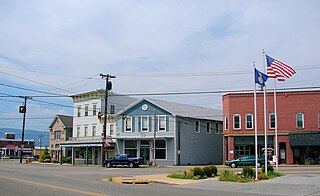
Luray is the county seat of Page County, Virginia, United States, in the Shenandoah Valley in the northern part of the Commonwealth. The population was 4,895 at the 2010 census.

Shenandoah is a town in Page County, Virginia, United States. The population was 2,373 at the 2010 census.
Elkton is an incorporated town in Rockingham County, Virginia, United States. It is included in the Harrisonburg Metropolitan Statistical Area. The population was 2,762 at the 2010 census. Elkton was named for the Elk Run stream.
New Market is a town in Shenandoah County, Virginia, United States. Founded as a small crossroads trading town in the Shenandoah Valley, it has a population of 2,146 as of the most recent 2010 U.S. census. The north–south U.S. 11 and the east–west U.S. 211 pass near it and cross Massanutten Mountain at the town's titular gap.

The Shenandoah Valley is a geographic valley and cultural region of western Virginia and the Eastern Panhandle of West Virginia in the United States. The valley is bounded to the east by the Blue Ridge Mountains, to the west by the eastern front of the Ridge-and-Valley Appalachians, to the north by the Potomac River and to the south by the James River. The cultural region covers a larger area that includes all of the valley plus the Virginia highlands to the west, and the Roanoke Valley to the south. It is physiographically located within the Ridge and Valley province and is a portion of the Great Appalachian Valley.

The Great Appalachian Valley, also called The Great Valley or Great Valley Region, is one of the major landform features of eastern North America. It is a gigantic trough—a chain of valley lowlands—and the central feature of the Appalachian Mountain system. The trough stretches about 1,200 miles (1,900 km) from Quebec to Alabama and has been an important north-south route of travel since prehistoric times.

The Shenandoah River is a tributary of the Potomac River, 55.6 miles (89.5 km) long with two forks approximately 100 miles (160 km) long each, in the U.S. states of Virginia and West Virginia. The principal tributary of the Potomac, the river and its tributaries drain the central and lower Shenandoah Valley and the Page Valley in the Appalachians on the west side of the Blue Ridge Mountains, in northwestern Virginia and the Eastern Panhandle of West Virginia.
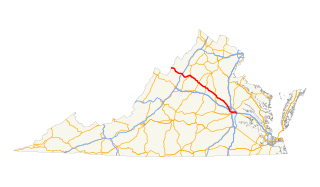
U.S. Route 211 is a spur of US 11 in the U.S. state of Virginia. Known for most of its length as Lee Highway, the U.S. Highway runs 59.09 miles (95.10 km) from Interstate 81 (I-81) and Virginia State Route 211 in New Market east to US 15 Business, US 29 Business, and US 211 Business in Warrenton. US 211 connects the Shenandoah Valley with the Piedmont town of Warrenton via Luray and Sperryville, where the highway runs concurrently with US 340 and US 522, respectively.
U.S. Route 340 is a spur route of US 40, and runs from Greenville, Virginia to Frederick, Maryland. In Virginia, it runs north–south, parallel and east of US 11, from US 11 north of Greenville via Waynesboro, Grottoes, Elkton, Luray, Front Royal, and Berryville to the West Virginia state line. A short separate piece crosses northern Loudoun County on its way from West Virginia to Maryland.

Massanutten Mountain is a synclinal ridge in the Ridge-and-Valley Appalachians, located in the U.S. state of Virginia. It is near the West Virginia state line.
Swift Run Gap is a wind gap in the Blue Ridge Mountains located in the U.S. state of Virginia.
Thornton Gap is a wind gap located in the Blue Ridge Mountains in Virginia separating the Shenandoah Valley from the Piedmont region of the state.
U.S. Route 33 is a part of the U.S. Highway System that runs from Elkhart, Indiana to Richmond, Virginia. In Virginia, the U.S. Highway runs 135.60 miles (218.23 km) from the West Virginia state line near Rawley Springs east to its eastern terminus at SR 33 in Richmond. US 33 is the primary east–west highway of Rockingham County, which lies in the Shenandoah Valley. The highway connects the independent city of Harrisonburg, the town of Elkton, and an entrance to Shenandoah National Park. East of the Blue Ridge Mountains, US 33 connects the Piedmont communities of Stanardsville, Gordonsville, and Louisa. The U.S. Highway is a major suburban and urban route in the Richmond metropolitan area. Within Richmond, US 33 runs concurrently with US 250. SR 33 continues from US 33's eastern terminus as a state-numbered extension of the U.S. Highway that connects Richmond with Virginia's Middle Peninsula.

Fort Valley is a mountain valley located primarily in Shenandoah County, Virginia. It is often called "valley within a valley" as it lies between the two arms of the northern part of the Blue Ridge mountain range in the Shenandoah Valley in the Ridge-and-Valley Appalachians geological zone.

New Market Gap is a wind gap in the Massanutten Mountain in Virginia. The 1,804 feet (550 m) gap is located approximately in the middle of the range, dividing it into north and south sections.
Smith Creek is a 35.5-mile-long (57.1 km) tributary stream of the North Fork of the Shenandoah River in the Shenandoah Valley of Virginia. Its watershed comprises 106 square miles (270 km2) within Shenandoah and Rockingham counties on the western slope of the Massanutten Mountain ridge. Its headwaters lie in Rockingham County just north of Harrisonburg, and its confluence with the North Fork of the Shenandoah River is located just south of Mount Jackson.

Fishers Gap is a wind gap of the Blue Ridge Mountains located on the border of Madison County and Page County in Virginia in the Shenandoah National Park. Both Skyline Drive and the Appalachian Trail pass across the gap.
