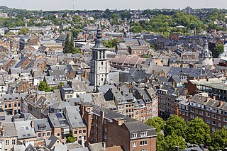
Namur is a city and municipality in Wallonia, Belgium. It is the capital both of the province of Namur and of Wallonia, hosting the Parliament of Wallonia, the Government of Wallonia and its administration.

The County of Hainaut, sometimes spelled Hainault, was a territorial lordship within the medieval Holy Roman Empire that straddled the present-day border of Belgium and France. Its most important towns included Mons, now in Belgium, and Valenciennes, now in France.

Namur was a county of the Carolingian and later Holy Roman Empire in the Low Countries, a region in northwestern Europe. Its territories largely correspond with the present-day French-speaking Belgian arrondissement Namur together with the northwestern part of the arrondissement Dinant, which are both part of the modern province of Namur. The modern provincial boundaries are based on the French Republican department of Sambre-et-Meuse.
Albert I the son of Robert I, was a count who held the castle of Namur and a county in the Lommegau. His county came to be referred to as the County of Namur in records during his lifetime.

The County of Loon was a county in the Holy Roman Empire, which corresponded approximately with the modern Belgian province of Limburg. It was named after the original seat of its count, Loon, which is today called Borgloon. During the middle ages the counts moved their court to a more central position in Kuringen, which today forms part of Hasselt, capital of the province.

The Condrusi were an ancient Belgic-Germanic tribe dwelling in what is now eastern Belgium during the Gallic Wars and the Roman period. Their ethnic identity remains uncertain. Caesar described them as part of the Germani Cisrhenani, but their tribal name is probably of Celtic origin. Like other Germani Cisrhenani tribes, it is possible that their old Germanic endonym came to be abandoned after a tribal reorganization, that they received their names from their Celtic neighbours, or else that they were fully or partially assimilated into Celtic culture at the time of the Roman invasion of the region in 57 BC.
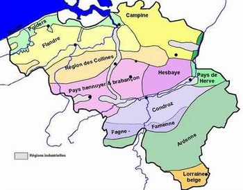
The Hesbaye, or Haspengouw, is a traditional cultural and geophysical region in eastern Belgium. It is a loamy plateau region which forms a watershed between the Meuse and Scheldt drainage basins. It has been one of the main agricultural regions in what is now Belgium since before Roman times, and specifically named in records since the Middle Ages, when it was an important Frankish pagus or gau, called Hasbania in medieval Latin.

The County of Huy was a comital jurisdiction of Lotharingia during the early Middle Ages, centred on the town of Huy and its citadel overlooking the Meuse.
The Condroz is a natural region in Wallonia, the French-speaking part of Belgium, located between the Ardennes and the Meuse. Its unofficial capital is Ciney. The region preserves the name of the Condrusi, a Germanic tribe which inhabited the area during and before the Roman era.
Robrecht or Robert I of Namur was a 10th-century count of Namur in what is now Belgium.
Famenne is a natural region in Wallonia. Together with The Fagne or la Fagne, west of the river Meuse, it is part of the Fagne-Famenne natural region. The two regions are often grouped together because they are quite similar both geographically and naturally.
Gilbert (Giselbert), Count of Maasgau was a Frankish noble in what would become Lotharingia, during his lifetime in the 9th century. The Carolingian dynasty created this "middle kingdom" and fought over it, and he is mentioned as playing a role on both sides.
The pagus or gau of Hasbania was a large early medieval territory in what is now eastern Belgium. It is now approximated by the modern French- and Dutch-speaking region called Hesbaye in French, or Haspengouw in Dutch — both being terms derived from the medieval one. Unlike many smaller pagi of the period, Hasbania apparently never corresponded to a single county. It already contained several in the 9th century. It is therefore described as a "Großgau", like the Pagus of Brabant, by modern German historians such as Ulrich Nonn.
Count Rudolf, was a count in Lower Lotharingia, who apparently held possessions in the Hesbaye region and in the area of Meuse river north of Maastricht. It has been proposed that he was a son of Reginar II, Count of Hainaut, and thus a member of the so-called Regnarid dynasty.
Count Emmo, Immo or Immon, was the name of at least one important Lotharingian nobleman in the 10th century, described by medieval annalists as a cunning strategist. Various life events of a nobleman of this name were recorded, although historians differ about exactly which records refer to the same person or people. The first record claimed for him shows him as a young noble granting land to a new vassal in the Condroz region in 934, a member of the entourage of Duke Gilbert of Lotharingia. During the revolt of Gilbert which ended at the Battle of Andernach in 939, he switched sides. After the revolt he was personally associated with the fort at Chèvremont, near Liège. It becomes difficult later in Immo's life to be sure that all records mentioning a count of this name are referring to the same person.
Sigard (Sigehard), was a tenth-century Lotharingian count in Hainaut and Liugas, between Liège and Aachen. Various relationships to others have been proposed for him, but these are all uncertain.
Liugas, Leuwa-gau, or Luihgau, was a small pagus or gau from the late 8th to mid-11th centuries, east of the Meuse river roughly between Liège, Maastricht, and Aachen, an area where Germany, Belgium and the Netherlands meet today. There were only a small number of mentions made of this territory, all between 779 and 1059.
The pagus of Brabant was a geographical region in the early Middle Ages, located in what is now Belgium. It was the first region known to have been called Brabant, and it included the modern capital of Belgium, Brussels. It was divided between the neighbouring counties of Flanders, Hainaut and Louvain (Leuven) in the eleventh century. It was the eastern part, which went to the Counts of Louvain, which kept the name in use, becoming the primary name of their much larger lordship. This led to other regions later being named Brabant - in particular, the French and Dutch-speaking areas east of the Dyle, including Leuven and Wavre, which are still known as "Brabant"; and secondly the province of North Brabant in the Netherlands.
The Maasgau, Masao, or Maasland, was an early medieval region or pagus, on both sides of the Meuse, stretching north of the city of Maastricht.
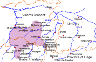
The county of Brunengeruz existed in the 10th and 11th centuries in what is now eastern Belgium, between the town of Leuven on the river Dyle and Tienen on the river Gete. It was part of the larger region known as the Hesbaye. The name is sometimes interpreted with "corrected" forms such as Brunenrode, because the Latin spellings are believed to derive from Brūninga roþa, meaning a forest clearing belonging to the kinsfolk of Bruno.