Related Research Articles
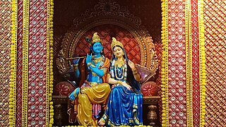
Braj, also known as Vraj, Vraja, Brij or Brijbhumi, is a region in India on both sides of the Yamuna river with its centre at Mathura-Vrindavan in Uttar Pradesh state encompassing the area which also includes Palwal, Ballabhgarh and Nuh in Haryana state, Deeg, Bharatpur, Karauli, and Dholpur in Rajasthan state and Morena District in Madhya Pradesh. Within Uttar Pradesh, it is very well demarcated culturally, the area stretches from the Mathura, Aligarh, Agra, Hathras and districts up to the Etah district. Braj region is associated with Radha and Krishna who according to scriptures were born in Barsana and Mathura respectively. It is the main centre of Krishna circuit of Hindu pilgrimage.

Hathras is a historical city in Uttar Pradesh, India. It is the headquarters of Hathras district, formed on 3 May 1997 by merging parts of Aligarh, Mathura and Agra. It is part of the Aligarh Division.
Braj is a language within the Indo-Aryan language family spoken in the Braj region in Western Uttar Pradesh centered on Mathura. Along with Awadhi, it was one of the two predominant literary languages of North-Central India before gradually merging and contributing to the development of standardized Hindi in the 19th century. It is spoken today in its unique form in many districts of west Uttar Pradesh, often referred to as 'Central Braj Bhasha'.
Govardhan also called Giriraj, is a key pilgrimage centre in India and a municipal town; a nagar panchayat; seat of an MLA of Uttar Pradesh; a Tehsil, in Mathura district in India in the state of Uttar Pradesh. About 23 kilometres from Mathura, the town is on the road link between Mathura and Deeg.

Etah district is one of the districts of Uttar Pradesh, India, since 1854. Etah City is the district headquarters. Etah district is a part of Aligarh Division.

Ayodhya district is one of the 75 districts in the northern Indian state of Uttar Pradesh. The city of Ayodhya is its administrative headquarters. The district occupies an area of 2,522 square kilometres (974 sq mi), and had a population of 2,470,996 in the 2011 census. Ayodhya district shares its borders with 6 districts of Uttar Pradesh. It is bordered by Gonda and Basti districts on the northern side, Amethi and Sultanpur districts on the south, and Ambedkar Nagar and Barabanki districts share the border on the east and west.
Mursan is a town and a Nagar Panchayat in Hathras district in the Indian state of Uttar Pradesh. The primary spoken language is a dialect of Hindi, Braj Bhasha, which is closely related to Khariboli. In past, Raja Mahendra Pratap Singh was the ruler of Mursan. At present, the Chairman of Mursan is Deshraj Singh. Former King of Mursan Kingdom:
Mathura district is situated along the banks of the river Yamuna is a district of Uttar Pradesh state of north-central India. The historic city of Mathura is the district headquarters. Mathura district is home to many important sites associated with goddess Radha and Lord Krishna, who was born in Mathura and grew up in the nearby town of Vrindavan. Both cities are some of the most sacred sites in the Vaishnava tradition, making Mathura district an important Hindu pilgrimage centre.
Chhata is a small city and a nagar panchayat in Mathura district in the state of Uttar Pradesh, India. Earlier this city was known as Chhatravan.
Musandi is a village in the Unnao district, in the Indian state of Uttar Pradesh.
Walidpur is a village in Mau district in the Indian state of Uttar Pradesh.
Chhai Pokhar is a village in the district of Agra in the Indian state of Uttar Pradesh. It is nearby Achhnera or Achnera, connected by road on three sides of the village and by rail. Khera Sandhan is the nearest railway station at about 1 km from the village on Agra- Achnera-Mathura section of NW Railway. It is also known as Three Towers' Village.

Bhidauni is a village and Gram panchayat of two villages, Kewat Nagla and Bhidauni officially known as Bhidauni Bangar located between the Yamuna river and Yamuna Expressway in the Mat Tehsil of Mathura district, Uttar Pradesh, India. It is situated approximately 45 kilometers away from Mathura City, on the Raya Road connecting via Mant to Naujheel Road.
Bhavanpura is a village in the Govardhan Tehsil in the Indian state of Uttar Pradesh. Bhawanpura is a village in the Goverdan tehsil of Mathura district of the Indian state of Uttar Pradesh. It is located about 22 km from its District headquerters Mathura.
Chhata Assembly constituency is one of the 403 constituencies of the Uttar Pradesh Legislative Assembly, India. It is a part of the Mathura district and one of the five assembly constituencies in the Mathura Lok Sabha constituency. First election in this assembly constituency was held in 1952 after the "DPACO (1951)" was passed in 1951. After the "Delimitation of Parliamentary and Assembly Constituencies Order" was passed in 2008, the constituency was assigned identification number 81.

Mant Assembly constituency is one of the 403 constituencies of the Uttar Pradesh Legislative Assembly, India. It is a part of the Mathura district and one of the five assembly constituencies in the Mathura Lok Sabha constituency. First election in this assembly constituency was held in 2012 after the "Delimitation of Parliamentary and Assembly Constituencies Order, 2008" was passed and the constituency was formed in 2008. The constituency is assigned identification number 82.
Chhata is a tehsil in Mathura district of Uttar Pradesh state, India. Its headquarters is Chhata town. It is part of Agra division. It is located 35 km north of the District headquarters Mathura, and 413 km east of the state capital Lucknow.
Mai is a village in Sadabad Block in Mahamaya Nagar District of Uttar Pradesh State, India. It belongs to Aligarh Division. It is located 40 km towards the South of the District headquarters Hathras and 16 km from Sadabad. 350 km from the State capital Lucknow. Mai Pin code is 281306 and the postal head office is Sadabad. Chirawali (1 km), Saroth (2 km), Ghooncha (2 km), Nanau (3 km), Garhumrao (3 km), Nagla Banarasi (1 km) are the nearby Villages to Mai. Mai is surrounded by Khandauli Block towards the East, Baldeo Block towards the west, Agra Block towards the South, and Sehpau Block towards the East.
Dautana is a semi-urban village situated in NH2 Delhi Agra Highway. Dautana village is located in Chhata Tehsil of Mathura district in Uttar Pradesh, India. Dautana
Kotwan is a village in the Mathura district of Uttar Pradesh, India. It is the site where according to Hinduism, Krishna spent his childhood and is one of the main places in the Braj Bhoomi region. The Village is about 100 km away from Agra.
References
- ↑ "Paigaon Village Population - Chhata - Mathura, Uttar Pradesh". www.census2011.co.in. Retrieved 19 March 2017.
27°47′N77°32′E / 27.783°N 77.533°E
| | This Mathura district location article is a stub. You can help Wikipedia by expanding it. |