Pakala, Nepal

Last updated
Pakala
पकला
Village Development Committee
Nepal location map.svg
Red pog.svg
Pakala
Location in Nepal
Coordinates: 28°00′N82°54′E / 28.00°N 82.90°E / 28.00; 82.90 Coordinates: 28°00′N82°54′E / 28.00°N 82.90°E / 28.00; 82.90
CountryFlag of Nepal.svg    Nepal
Region Mid-Western
Zone Rapti Zone
District Pyuthan District
VDC Pakala
Population (2001 Census [1] )
  Total 3,799
 719 households
Time zone Nepal Time (UTC+5:45)

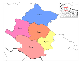
Pakala is a town and Village Development Committee in Pyuthan, a Middle Hills district of Rapti Zone, western Nepal.

Town settlement that is bigger than a village but smaller than a city


A town is a human settlement. Towns are generally larger than villages but smaller than cities, though the criteria to distinguish them vary considerably between different parts of the world.

Pyuthan District District in Nepal

Pyuthan District (Nepali: प्युठान जिल्लाListen , is a "hill" district some 250 km west of Kathmandu in Province No. 5 in midwestern Nepal. Pyuthan covers an area of 1,309 km² with population of 212,484 in 2001 and 226,796 in 2011. Pyuthan Khalanga is the district's administrative center.

Rapti Zone Zone in Nepal

Rapti Zone was one of the fourteen zones, located in the Mid-Western Development Region of Nepal. It was named after the West Rapti River which drains Rolpa, Pyuthan and part of Dang districts. The remainder of Dang and part of Salyan district are drained by the Babai. The remainder of Salyan and all of Rukum districts are drained by the Bheri.

Contents

Villages in this VDC

Ward Lat. Lon Elev.
Andherigaun अँधेरीगाउँ 9 28°01'N 82°55'E   810m
Arjam अर्जाम 8 28°00'N 82°54'E   950
Bel Pokhari बेल पोखरी 28°01'N 82°55'E   670
Bwase बवासे 27°59'N 82°53'E 1,050
Darimpata दारिमपाटा 3 28°00'N 82°53'E 1,350
Gaude गौडे 27°58'N 82°53'E 1,070
Ghorlikholagaun घोर्लीखोलागाउँ 28°00'N 82°55'E   868
Hattikhal हात्तिखाल 27°59'N 82°55'E 1,610
Jabune जाबुने 5 28°00'N 82°53'E 1,438
Jadi जाडी 28°02'N 82°54'E   710
Kaule काउले 27°59'N 82°54'E 1,550
Khara खारा 27°58'N 82°54'E   450
Khasre खस्रे 27°58'N 82°53'E   450
Kolbang कोलबाङ 7 27°59'N 82°53'E 1,150
Lumja लुम्जा 27°58'N 82°54'E 1,150
Okhari ओखारी 27°58'N 82°54'E   850
Ronmakhola gaun रोन्माखोलागाउँ 27°58'N 82°55'E   830
Sadanchaur सादनचौर 28°01'N 82°54'E   920
Salbas सालबास 27°59'N 82°53'E 1,190
Thar Damar थार दमार 27°58'N 82°53'E   550

[2]

Related Research Articles

Barjibang Village Development Committee in Mid-Western, Nepal

Barjibang is a village and Village Development Committee in Pyuthan, a Middle Hills district of Rapti Zone, western Nepal.

Bhingri Village Development Committee in Mid-Western, Nepal

Bhingri is a Village Development Committee in Pyuthan, a Middle Hills district of Rapti Zone, western Nepal.

Bijuli Village Development Committee in Mid-Western, Nepal

Bijuli is a town and Village Development Committee in Pyuthan, a Middle Hills district of Rapti Zone, western Nepal.

Chunja, Rapti Village Development Committee in Mid-Western, Nepal

Chunja is a town and Village Development Committee in Pyuthan, a Middle Hills district of Rapti Zone, western Nepal.

Damri, Nepal Village Development Committee in Mid-Western, Nepal

Damri is a town and Village Development Committee in Pyuthan, a Middle Hills district of Rapti Zone, western Nepal.

Dangbang Village Development Committee in Mid-Western, Nepal

Dangbang is a town and Village Development Committee in Pyuthan, a Middle Hills district of Rapti Zone, western Nepal.

Dharampani, Rapti Village Development Committee in Mid-Western, Nepal

Dharampani is a village and Village Development Committee in Pyuthan, a Middle Hills district of Rapti Zone, western Nepal.

Dhubang Village development committee in Mid-Western, Nepal

Dhubang is a town and village development committee in Pyuthan, a Middle Hills district of Rapti Zone, western Nepal.

Khung Village Development Committee in Mid-Western, Nepal

Khung is a village and Village Development Committee in Pyuthan District in Pyuthan, a Middle Hills district of Rapti Zone, western Nepal.

Kochibang Village Development Committee in Mid-Western, Nepal

Kochibang is a village and Village Development Committee in Pyuthan, a Middle Hills district of Rapti Zone, western Nepal.

Ligha Village Development Committee in Mid-Western, Nepal

Ligha also known as Lipa is a village and Village Development Committee in Pyuthan, a Middle Hills district of Rapti Zone, western Nepal.

Libang, Pyuthan Village Development Committee in Mid-Western, Nepal

Libang is a town and Village Development Committee in Pyuthan, a Middle Hills district of Rapti Zone, western Nepal.

Lung, Nepal Village Development Committee in Mid-Western, Nepal

Lung is a town and Village Development Committee in Pyuthan, a Middle Hills district of Rapti Zone, western Nepal.

Bangemarkot Village Development Committee in Mid-Western, Nepal

Bangemarot is a Village Development Committee in Pyuthan, a Middle Hills district of Rapti Zone, western Nepal.

Markabang Village Development Committee in Mid-Western, Nepal

Markabang is a village and Village Development Committee in Pyuthan, a Middle Hills district of Rapti Zone, western Nepal.

Naya Gaun, Rapti Village Development Committee in Mid-Western, Nepal

Naya Gaun is a village and Village Development Committee in Pyuthan, a Middle Hills district of Rapti Zone, western Nepal.

Puja, Nepal Village Development Committee in Mid-Western, Nepal

Pujan is a town and Village Development Committee in Pyuthan, a Middle Hills district of Rapti Zone, western Nepal.

Rajwara Village Development Committee in Mid-Western, Nepal

Rajwara is a town and Village Development Committee in Pyuthan, a Middle Hills district of Rapti Zone, western Nepal.

Ramdi Village Development Committee in Mid-Western, Nepal

Ramdi is a village and Village Development Committee in Pyuthan, a Middle Hills district of Rapti Zone, western Nepal.

Torbang Village Development Committee in Mid-Western, Nepal

Torbang is a town and Village Development Committee in Pyuthan, a Middle Hills district of Rapti Zone, western Nepal.

References

  1. "Nepal Census 2001". Nepal's Village Development Committees. Digital Himalaya . Retrieved 21 September 2008.
  2. "Index of Geographical Names of Nepal, Volume IV: Mid Western Development Region, List of Settlements, Pyuthan" (PDF). Government of Nepal, National Geographic Information Infrastructure Program. Archived from the original (PDF) on 2011-07-24. Retrieved 2011-03-12.