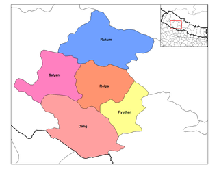
Rapti Zone was one of the fourteen zones, located in the Mid-Western Development Region of Nepal. It was named after the West Rapti River which drains Rolpa, Pyuthan and part of Dang districts. The remainder of Dang and part of Salyan district are drained by the Babai. The remainder of Salyan and all of Rukum districts are drained by the Bheri.
Dang District is a district of Lumbini Province located in the Inner Terai of midwestern Nepal. Deukhuri Valley of the district is the capital of the province and is the second largest valley of Asia surrounded by Sivalik Hills and the Mahabharata Range. The district headquarter Ghorahi is the seventh largest city and aslo the lumbini province headqatar the largest sub-metropolitan city of Nepal. Tulsipur sub-metropolitan city, the second largest city of Dang, is a major transportation hub with extensive road and air networks. The district covers an area of 2,955 km2 and has a population of 674,993.

Pyuthan District (Nepali: प्युठान जिल्ला, is a "hill" district some 427.6 km west of Kathmandu in Lumbini Province in midwestern Nepal. Pyuthan covers an area of 1,309 km2 with population of 212,484 in 2001 and 226,796 in 2011. Pyuthan Khalanga is the district's administrative center.

Ghorahi is the largest sub-metropolitan city by area and population of Lumbini Province. The city lies in Lumbini Province in the Mid-Western part of Nepal. It is the largest city of Dang Deukhuri District of southwest Nepal. Located in the Inner Terai region, it lies 413 kilometres (257 mi) south-west of Nepal's capital Kathmandu and is one of the Counter Magnets being developed as an alternative centre of growth to help ease the migration and population explosion in the Kathmandu metropolitan area. It is the largest city of the Rapti Zone and is surrounded by the Sivalik Hills to the south and Mahabharata Range to the north.

Solududhkunda (earlier:Dudhkunda) is the only municipality of Solukhumbu District. Located in Koshi Province of Nepal. The town of Salleri, which is located within the municipality is the headquarter of Solukhumbu District It was formed in 2014 by merging four VDCs: Salleri, Garma, Loding Tamakhani and Beni and was divided into 9 wards. Total area of the municipality had 254.3 square kilometres (98.2 sq mi) and population of municipality had 20,399 individuals living in 5,368 households.
Burtibang is a village development committee in Baglung District in the Dhaulagiri Zone of central Nepal. Burtibang is the second-largest commercial city in the district after Baglung.
Tulsipur is a Sub-Metropolitan City in Dang District of Lumbini Province of Nepal. It is the district's second most populous city after Ghorahi. It was established in 1992 by merging the former village development committees (VDCs) Tulsipur and Amritpur. In 2014, it was expanded with the addition of VDCs of Urahari, Tarigaun, Pawannagar and Halwar. At the 2011 Nepal census, it had a population of 141,528 people in 31,243 households. Tulsipur Old Peepal bot best place
Bijaya Nagar is a town and market center located in Pyuthan Municipality in Pyuthan, a Middle Hills district of Lumbini Province, western Nepal. The formerly Village Development Committee along with Pyuthan Khalanga, Bijubar, Dakha Kwadi, Bijaya Nagar, Dharmawati, Maranthana and Khaira was merged to form the new municipality since 18 May 2014.
Bijuwar is a town and market center in Pyuthan Municipality in Pyuthan, a Middle Hills district of Rapti Zone, western Nepal. The former Village Development Committee along with Pyuthan Khalanga, Bijubar, Dakha Kwadi, Bijaya Nagar, Dharmawati, Maranthana and Khaira were merged to form the new municipality since 18 May 2014. Bijuwar is the main commercial center in the valley of Jhimruk Khola.
Dakha Kwadi is a town and market center in Pyuthan Municipality of Pyuthan, a Middle Hills district of Rapti Zone, western Nepal. The former Village Development Committee along with Pyuthan Khalanga, Bijubar, Dakha Kwadi, Bijaya Nagar, Dharmawati, Maranthana and Khaira were merged to form the new municipality since 18 May 2014.
Dharmawati is a town and market center in Pyuthan Municipality in Pyuthan, a Middle Hills district of Rapti Zone, western Nepal. The former Village Development Committee along with Pyuthan Khalanga, Bijubar, Dakha Kwadi, Bijaya Nagar, Dharmawati, Maranthana and Khaira were merged to form the new municipality since 18 May 2014.
Dhobaghat -- also called Udayapurkot --- is a village and Village Development Committee in Pyuthan, a Middle Hills district of Rapti Zone, western Nepal.
Dhungegadhi is a town and Village Development Committee in Pyuthan, a Middle Hills district of Rapti Zone, western Nepal.
Hansapur is a Village Development Committee in Pyuthan, a Middle Hills district of Rapti Zone, western Nepal. The village lies to the northeast of the district sharing its border mainly to Aargakhanchi. The area is mostly inhabited by Brahmins and other castes, too. The village or VDC is a developing area in the district with proper facilities of electricity and communication. The place is well established for ginger (Aduwa) and bee honey.
Majhakot is a village and Village Development Committee in Pyuthan, a Middle Hills district of Rapti Zone, western Nepal.
Maranthana is a town and market center in Pyuthan Municipality in Pyuthan, a Middle Hills district of Rapti Zone, western Nepal. The formerly Village Development Committee along with Pyuthan Khalanga, Bijubar, Dakha Kwadi, Bijaya Nagar, Dharmawati, Maranthana and Khaira was merged to form the new municipality since 18 May 2014.
Okharkot is a town and Village Development Committee in Pyuthan, a Middle Hills district of Rapti Zone, western Nepal.

Musikot is a municipality and the district headquarter of Western Rukum District in Karnali Province of Nepal that was established as Musikot Khalanga on 2 December 2014 by merging the two former Village development committees Musikot and Khalanga. From 2014 until 2018, Musikot was called Musikot Khalanga and until 2017 served as the district headquarter of Rukum District. It lies on the bank of Sani Bheri River. It borders with Eastern Rukum in the east, Sanibheri rural municipality in the west, Banfikot rural municipality in the north and Tribeni rural municipality and Rolpa district in the south.

Former administrative units of Nepal are administrative divisions during Kingdom of Nepal. In 2008 Nepal was proclaimed a federal republic and old administrative units restricted after adoption of new constitution on 20 September 2015.
Jhimruk is a Rural municipality located within the Pyuthan District of the Lumbini Province of Nepal. The rural municipality spans 106.93 square kilometres (41.29 sq mi) of area, with a total population of 27,931 according to a 2011 Nepal census.


