Tiram

Last updated
Mandabi Gaupalika 1

तिराम

Dhurunga
Village Development Committee
Nepal adm location map.svg
Red pog.svg
Mandabi Gaupalika 1
Location in Nepal
Coordinates: 28°01′N82°46′E / 28.02°N 82.77°E / 28.02; 82.77 Coordinates: 28°01′N82°46′E / 28.02°N 82.77°E / 28.02; 82.77
CountryFlag of Nepal.svg    Nepal
Region Mid-Western
Zone Rapti Zone
District Pyuthan District
VDC Tiram
Wards1
Population
 (2001 Census [1] )
  Total4,926
 827 households
Time zone UTC+5:45 (Nepal Time)
28°01′04″N082°46′14″E / 28.01778°N 82.77056°E / 28.01778; 82.77056 (Tiram, Pyuthan district, Nepal)

Tiram is a town and Village Development Committee in Pyuthan, a Middle Hills district of Rapti Zone, western Nepal.

Town settlement that is bigger than a village but smaller than a city

A town is a human settlement. Towns are generally larger than villages but smaller than cities, though the criteria to distinguish them vary considerably between different parts of the world.

Pyuthan District District in Nepal

Pyuthan District(Nepali: प्युठान जिल्लाListen , is a "hill" district some 250 km west of Kathmandu in Province No. 5 in midwestern Nepal. Pyuthan covers an area of 1,309 km² with population of 212,484 in 2001 and 226,796 in 2011. Pyuthan Khalanga is the district's administrative center.

Rapti Zone Zone in Nepal

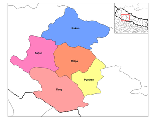
Rapti Zone was one of the fourteen zones, located in the Mid-Western Development Region of Nepal. It was named after the West Rapti River which drains Rolpa, Pyuthan and part of Dang districts. The remainder of Dang and part of Salyan district are drained by the Babai. The remainder of Salyan and all of Rukum districts are drained by the Bheri.

Contents

Tiram is a hill town surrounded by terraced rice fields with a mostly Bahun and Chhetri population. It is the home of a politically prominent family named Upadhyaya. Tiram is situated on a spur of the Mahabharat Range overlooking Mardi Khola, the largest tributary of the Rapti.

Bahun or Khas Brahmin(Nepali: खस ब्राह्मण) or Nepali Brahman is a caste among Khas ethnic Pahari people. Bahun is a local colloquial term for the Nepali-speaking hill Brahmins. According to 2011 Nepal census, Brahman/Bahun or Brahmin-Hill stands as second most populous group after Chhetri in Nepal.

Chhetri Kshatriya caste of patrilineal Khas-Aryan descent

Chhetri, historically called Kshettriya or Kshetriya, are Nepali speakers of Khas Rajput community some of whom trace their origin to migration from medieval India. Chhetri was a caste of administrators, governor and military elites in medieval Khas Kingdom and Gorkha Kingdom. The nobility of Gorkha Kingdom were mainly based from Chhetri families and they had a strong presence in civil administration affairs. The bulk of Prime Ministers of Nepal before democratization of Nepal belonged to this caste as a result of old Gorkhali aristocracy. Gorkha-based aristocratic Chhetri families were Pande dynasty, Basnyat dynasty, Thapa dynasty and Kunwars.

West Rapti River river in Nepal

West Rapti drains Rapti Zone in Mid-Western Region, Nepal, then Awadh and Purvanchal regions of Uttar Pradesh state, India before joining the Ghaghara -- a major left bank tributary of the Ganges known as the Karnali inside Nepal.

A motorable gravel road from Tribhuwannagar, Dang Deokhuri District passes through the town and descends toward a junction along Mardi Khola with a more important spur road linking the administrative centers of Pyuthan and Rolpa districts to the main east-west Mahendra Highway.

Liwang, Rolpa Municipality in Rapti Zone, Nepal

Liwang is district headquarters and municipality in Rolpa District in the Rapti Zone of southwestern Nepal. At the time of the 1991 Nepal census it had a population of 8425.

Mahendra Highway road in Nepal

Mahendra Highway, also called East-West Highway runs across the Terai geographical region of Nepal, from Mechinagar in the east to Bhim Datta in the west, cutting across the entire width of the country. It is the longest highway in Nepal and was constructed by CPWD/PWD Nepali and Indian engineers.

Villages in this VDC

Ward Lat. Lon Elev.
Amdandaआमडाँडा28°02'N82°45'E  810m
Amghatआमघाट28°01'N82°48'E  580
Arkhaleअर्खले27°58'N82°46'E1,230
Bade Chaurबडे चौर28°02'N82°45'E  690
Bhingrikholagaunभिङग्रीखोलागाउँ527°59'N82°48'E  870
Bhirkunaभिरकुना27°59'N82°48'E  910
Budhichaurबुढीचौर627°59'N82°47'E1,136
Dhaire Khapteधैरे ख्ण्टे27°58'N82°46'E1,450
Ghyakhoreघ्याखोरे27°59'N82°49'E  730
Goddharaगोद्धारा27°59'N82°46'E1,350
Kateni Chhedaकटेनी छेडा27°59'N82°47'E1,530
Kharibangखरीबाङ28°00'N82°46'E  990
Kimchaurकिमचौर728°01'N82°45'E1,198
Kumaltarकुमालटार328°02'N82°47'E  570
Mutahaमुताहा28°00'N82°49'E  615
Nigreliनिग्रेली27°59'N82°45'E1,410
Pangbangपाङबाङ828°00'N82°45'E  990
Pangkotपाङकोट927°59'N82°45'E  570
Rajjeरज्जे27°59'N82°45'E1,130
Siddhathanसिद्धथान27°58'N82°47'E1,690
Simalchaurसिमलचौर28°01'N82°47'E  605
Simleसिम्ले27°59'N82°47'E1,430
Takuraटाकुरा27°59'N82°48'E1,310
Thadi Odarठाडी ओडार28°00'N82°49'E  650
Thakeleniथक्लेनी428°01'N82°48'E  879
Timileटिमिले28°02'N82°46'E  585
Tiramतिराम128°01'N82°46'E1,225

[2]

Related Research Articles

Pyuthan Municipality Municipality in Mid-Western, Nepal

Pyuthan is municipality in Pyuthan District, a Middle Hills district of Rapti Zone, Mid-western Nepal. It is also the District Headquarter and the administrative center. The municipality was established on 18 May 2014 by merging the existing Pyuthan Khalanga, Bijubar, Dakha Kwadi, Bijaya Nagar, Dharmawati, Maranthana and Khaira village development committees.

Bangesal Village Development Committee in Mid-Western, Nepal

Bangesal is both a town and Pyuthan District, Nepal's southernmost Village Development Committee; also Pyuthan's lowest in elevation. This VDC is in the Siwalik hills north of Deukhuri Valley.

Baraula Village Development Committee in Mid-Western, Nepal

Baraula is a town and Village Development Committee in Pyuthan, a Middle Hills district of Rapti Zone, western Nepal.

Bijuwar Place in Mid-Western, Nepal

Bijuwar is a town and market center in Pyuthan Municipality in Pyuthan, a Middle Hills district of Rapti Zone, western Nepal. The former Village Development Committee along with Pyuthan Khalanga, Bijubar, Dakha Kwadi, Bijaya Nagar, Dharmawati, Maranthana and Khaira were merged to form the new municipality since 18 May 2014. Bijuwar is the main commercial center in the valley of Jhimruk Khola.

Chunja, Rapti Village Development Committee in Mid-Western, Nepal

Chunja is a town and Village Development Committee in Pyuthan, a Middle Hills district of Rapti Zone, western Nepal.

Damri, Nepal Village Development Committee in Mid-Western, Nepal

Damri is a town and Village Development Committee in Pyuthan, a Middle Hills district of Rapti Zone, western Nepal.

Dhubang Village development committee in Mid-Western, Nepal

Dhubang is a town and village development committee in Pyuthan, a Middle Hills district of Rapti Zone, western Nepal.

Khabang Village Development Committee in Mid-Western, Nepal

Khabang is a town and Village Development Committee in Pyuthan, a Middle Hills district of Rapti Zone, western Nepal.

Lung, Nepal Village Development Committee in Mid-Western, Nepal

Lung is a town and Village Development Committee in Pyuthan, a Middle Hills district of Rapti Zone, western Nepal.

Narikot Village Development Committee in Mid-Western, Nepal

Narikot is a town and Village Development Committee in Pyuthan, a Middle Hills district of Rapti Zone, western Nepal.

Okharkot RM Development Committee in Mid-Western, Nepal

Okharkot is a town and Village Development Committee in Pyuthan, a Middle Hills district of Rapti Zone, western Nepal.

Pakala, Nepal Village Development Committee in Mid-Western, Nepal

Pakala is a town and Village Development Committee in Pyuthan, a Middle Hills district of Rapti Zone, western Nepal.

Phopli Village Development Committee in Mid-Western, Nepal

Phopli is a town and Village Development Committee in Pyuthan, a Middle Hills district of Rapti Zone, western Nepal.

Puja, Nepal Village Development Committee in Mid-Western, Nepal

Pujan is a town and Village Development Committee in Pyuthan, a Middle Hills district of Rapti Zone, western Nepal.

Rajwara Village Development Committee in Mid-Western, Nepal

Rajwara is a town and Village Development Committee in Pyuthan, a Middle Hills district of Rapti Zone, western Nepal.

Raspurkot Village Development Committee in Mid-Western, Nepal

Raspurkot is a town and Village Development Committee in Pyuthan, a Middle Hills district of Rapti Zone, western Nepal.

Sari, Nepal Village Development Committee in Mid-Western, Nepal

Sari is a town and Village Development Committee in Pyuthan, a Middle Hills district of Rapti Zone, western Nepal.

Torbang Village Development Committee in Mid-Western, Nepal

Torbang is a town and Village Development Committee in Pyuthan, a Middle Hills district of Rapti Zone, western Nepal.

References

  1. "Nepal Census 2001". Nepal's Village Development Committees. Digital Himalaya . Retrieved 21 September 2008.
  2. "Index of Geographical Names of Nepal, Volume IV: Mid Western Development Region, List of Settlements, Pyuthan" (PDF). Government of Nepal, National Geographic Information Infrastructure Program. Archived from the original (PDF) on 2011-07-24. Retrieved 2011-03-12.

Dhurunga