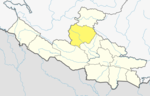
Rapti Zone was one of the fourteen zones, located in the Mid-Western Development Region of Nepal. It was named after the West Rapti River which drains Rolpa, Pyuthan and part of Dang districts. The remainder of Dang and part of Salyan district are drained by the Babai. The remainder of Salyan and all of Rukum districts are drained by the Bheri.
Okhaldhunga is the headquarters of the Okhaldhunga District in the Sagarmatha Zone of Nepal. At the time of the 1991 Nepal census it had a population of 3761 living in 790 individual households.

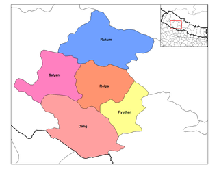
Rolpa, is a "hill" district in Lumbini Province of Nepal. Rolpa district covers an area of 1,879 km2 (725 sq mi) with population (2011) of 221,177. Rolpa town is the district's administrative center.
Rolpa is a municipality located in Rolpa District of Lumbini Province of Nepal. It is only municipality of Rolpa District. The municipality is surrounded by Sunchhahari and Swarnawati rural councils from the east, Tribeni & Madi rural councils from the West, Duikholi rural council from the North and Swarnawati & Runtigadhi from the South
Manma is the district headquarter of Kalikot District in Karnali Province, Nepal, a landlocked country of South Asia. The town is located at 29°8'60N 81°37'0E and has an altitude of 2033 metres.
Hatiya is a Village Development Committee in Baglung District in the Dhaulagiri Zone of central Nepal. At the time of the 1991 Nepal census it had a population of 6,015 and had 1131 houses in the town.
Khaskarkando is a town in Banke District in the Bheri Zone of south-western Nepal. At the time of the 1991 Nepal census it had a population of 4,582 and had 769 houses in the town. Now, it is a part of Nepalgunj sub-metropolitan city.
Neulapur is a village development committee in Bardiya District in Lumbini Province of south-western Nepal. At the time of the 1991 Nepal census it had a population of 8,194 and had 1053 houses in the town.
Kavre Nitya Chandeswori popularly known as "Kavre" is a village development committee in Kavrepalanchok District in the Bagmati Zone of central Nepal. Two of its V.D.C's are included in Dhulikhel Municipality in the year 2015 A.D. At the time of the 2011 Nepal census it had a population of 4,927 in 1,042 individual households.
Tulsipur is a Sub-Metropolitan City in Dang District of Lumbini Province of Nepal. It is the district's second most populous city after Ghorahi. It was established in 1992 by merging the former village development committees Tulsipur and Amritpur. In 2014, it was expanded and the village development committees of Urahari, Tarigaun, Pawannagar and Halwar. At the time of the 2011 Nepal census it had a population of 141,528 people living in 31,243 households.
Bijuwar is a town and market center in Pyuthan Municipality in Pyuthan, a Middle Hills district of Rapti Zone, western Nepal. The former Village Development Committee along with Pyuthan Khalanga, Bijubar, Dakha Kwadi, Bijaya Nagar, Dharmawati, Maranthana and Khaira were merged to form the new municipality since 18 May 2014. Bijuwar is the main commercial center in the valley of Jhimruk Khola.
Khalanga(Nepali: खलङ्गा) is the Headquarters of the Jajarkot District located in Karnali province of Nepal. Formerly it was a village development committee which incorporated to Bheri Municipality in 2015 when a new municipality was established.
Bajhakhet is a village development committee in Lamjung District in the Gandaki Zone of northern-central Nepal. At the time of the 1991 Nepal census it had a population of 3177 people living in 625 individual households.
Ishworpur is a Municipality in Sarlahi District in the Janakpur Zone of south-eastern Nepal. The municipality was established on 18 May 2014 by merging the existing Bela, Bhaktipur, Gaurishankar and Ishwarpur VDCs. At the time of the 1991 Nepal census it had a population of 14,014 people living in 249 individual households.
Khalanga is market center in Sharada Municipality in Salyan District of Karnali Province of Nepal. The place formerly existing as Village Development Committee was annexed to form a new municipality since 18 May 2014. It is the district headquarter of Salyan District. At the time of the 1991 Nepal census it had a population of 6380.
Malikarjun is a former village development committee that is now a Rural Municipality in Darchula District in Sudurpashchim Province of far western Nepal. Mallikarjun is named after the famous temple of lord Shiva Shree Shailyn shikar Malikarjun. At the time of the 1991 Nepal census it had a population of 1814 people living in 331 individual households.
Sakhi is a village development committee in Rolpa District in the Rapti Zone of north-eastern Nepal. At the time of the 1991 Nepal census it had a population of 2798 people living in 525 individual households.

Musikot is a municipality and the district headquarter of Western Rukum District in Karnali Province of Nepal that was established as Musikot Khalanga on 2 December 2014 by merging the two former Village development committees Musikot and Khalanga. From 2014 until 2018, Musikot was called Musikot Khalanga and until 2017 served as the district headquarter of Rukum District. It lies on the bank of Sani Bheri River. It borders with Eastern Rukum in the east, Sanibheri rural municipality in the west, Banfikot rural municipality in the north and Tribeni rural municipality and Rolpa district in the south.
Madanpokhara is a village development committee in Palpa District in the Lumbini Zone of southern Nepal. At the time of the 1991 Nepal census it had a population of 6269 people living in 1148 individual households.
Shivaraj is a Municipality in Kapilvastu District in the Lumbini Zone of southern Nepal. The former village development committee was transformed into Municipality from 18 May 2014 by merging the existing Birpur, Chanai, Bishunpur,Jawabhari and Shivapur village development committees. At the time of the 1991 Nepal census it had a population of 7241 people living in 1067 individual households.