Gokuleshwar is a Village Development Committee in Baitadi District in the Mahakali Zone of western Nepal. At the time of the 1991 Nepal census it had a population of 3,444 and had 601 houses in the town.
Manakamana is a village development committee in Gorkha District in the Gandaki Zone of northern-central Nepal. At the time of the 1991 Nepal census it had a population of 5,083 and had 889 houses in the town.
Khopasi is a village development committee in Kabhrepalanchok District in the Bagmati Zone of central Nepal. At the time of the 1991 Nepal census it had a population of 3453 in 676 individual households.
Laxmipur is a ward in the Ghorahi Sub Metropolitan which is located in Dang District in the Rapti Zone of south-western Nepal. At the time of the 1991 Nepal census it had a population of 9,075 persons residing in 1493 individual households.
Manpur is a town and Village Development Committee in Dang Deokhuri District in the Rapti Zone of south-western Nepal. At the time of the 1991 Nepal census it had a population of 9,960 persons residing in 1449 individual households.
Pawan Nagar is a town and Village Development Committee in Dang District in the Rapti Zone of south-western Nepal. At the time of the 1991 Nepal census it had a population of 11,428 persons living in 1961 individual households.Farming is adopted as the main occupation.
Bhagawati Tol is a former village development committee in Jajarkot District in the Karnali province of Nepal. At the time of the 1991 Nepal census it had a population of 2247 living in 424 individual households.
Rakhupiple is a village development committee in Myagdi District in the Dhaulagiri Zone of western-central Nepal. At the time of the 1991 Nepal census it had a population of 3538 people living in 782 individual households.
Lakhanpur, Nepal is a Village Development Committee in Ramechhap District in the Janakpur Zone of north-eastern Nepal. At the time of the 1991 Nepal census it had a population of 6058 people residing in 1100 individual households.
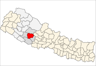
Chande is a village development committee in Salyan District in the Rapti Zone of western-central Nepal. At the time of the 1991 Nepal census it had a population of 4096 people living in 620 individual households.
Jhimpe is a village development committee in Salyan District in the Rapti Zone of western-central Nepal. At the time of the 1991 Nepal census it had a population of 5727 people living in 908 individual households.
Korbang Jhimpe is a village development committee in Salyan District in the Rapti Zone of western-central Nepal. At the time of the 2001 Nepal census it had a population of 636. According to the 2011 Nepal census Korbang Jhimpe had a population of 6,183.
Kotmala is a village development committee in Salyan District in the Rapti Zone of western-central Nepal. At the time of the 1991 Nepal census it had a population of 3735 people living in 649 individual households.
Marmaparikhanda is a village development committee in Salyan District in the Rapti Zone of western-central Nepal. At the time of the 1991 Nepal census it had a population of 3530 people living in 597 individual households.
Sibaratha is a village development committee in Salyan District in the Rapti Zone of western-central Nepal. At the time of the 1991 Nepal census it had a population of 4372 people living in 749 individual households.
Siddheswar is a village development committee in Salyan District in the Rapti Zone of western-central Nepal. At the time of the 1991 Nepal census it had a population of 3715 people living in 604 individual households.
Sinwang is a village development committee in Salyan District in the Rapti Zone of western-central Nepal. At the time of the 1991 Nepal census it had a population of 3012 people living in 538 individual households.
Inarwa is a village development committee in Saptari District in the Sagarmatha Zone of south-eastern Nepal. At the time of the 1991 Nepal census it had a population of 2582 people living in 416 individual households.
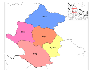
Dubring is a village development committee in Rolpa District in the Rapti Zone of north-eastern Nepal. At the time of the 1991 Nepal census it had a population of 4005 people living in 736 individual households.
Gharti Gaun is a village development committee in Rolpa District in the Rapti Zone of north-eastern Nepal. At the time of the 1991 Nepal census it had a population of 4105 people living in 734 individual households.