
Ongole is a city in Prakasam district of the Indian state of Andhra Pradesh. It is the headquarters of Prakasam district. It is famous for Ongole cattle, an indigenous breed of oxen.

Nellore district, officially known as Sri Potti Sriramulu Nellore district in Coastal Andhra Region, is one of the 26 districts in the Indian state of Andhra Pradesh. According to the 2011 Census, the district's population was 2,469,712 of which 29.07% was urban. Its administrative headquarters are located in Nellore city. Located in the Coastal Andhra region, the district is bordered by the Bay of Bengal to the east, Kadapa district and Annamayya district to the west, Prakasam district to the north, and Tirupati district to the south.

Prakasamdistrict is one of the twelve districts in the coastal Andhra region of the Indian state of Andhra Pradesh. It was formed in 1970 and reorganised on 4 April 2022. The headquarters of the district is Ongole. It is located on the western shore of Bay of Bengal and is bounded by Bapatla district and Palnadu districts in the north, Nandyal district in the west, Kadapa and Nellore districts in the south. A part of north west region also borders with Nagarkurnool district of Telangana. It is the largest district in the state with an area of 14,322 km2 (5,530 sq mi) and had a population of 22,88,026 as per 2011 Census of India.

Markapuram is a town in Prakasam district of the Indian state of Andhra Pradesh. It is a municipality and is the headquarters of Markapuram mandal in Markapuram revenue division. Markapuram is notable for the Chennakesava Swamy Temple, built by King Sri Krishnadevaraya. During Ratha Yatra there occurs a popular carnival; the town is also famous for Chenna Kesavaswamy on the day of Rathsapthami, which is attended by thousands of people coming from different parts of the state. It is the second-largest town in Prakasam district after Ongole and it is the main place within West Prakasam district to avail all facilities.
Kandukur or Kandukuru is a town in SPSR Nellore district of the Indian state of Andhra Pradesh. It is a municipality and the headquarters of Kandukur mandal as well as Kandukur revenue division. Kandukur Mandal is located at the south-east side of the Prakasam District having geographical area around 225 km2.There is only 1 city in the Kandukur Mandal, which is Kandukur Municipality having an area of 37.63 km2.
Narasaraopeta is a city and district headquarters of Palnadu District of the Indian state of Andhra Pradesh. The town is a municipality and mandal headquarters of Narasaraopet mandal and Headquarters of Narasaraopet revenue division. The town also is the seat of the court of Additional District Judge. Narasaraopet acts as a melting point for the Palnadu and Delta regions of the district. The town is also referred as the 'Gateway of Palnadu'. The main offices of Nagarjuna Sagar Jawahar Canal Operation & Maintenance Lingamguntla Circle are located in this town. Also it is considered as holy place.
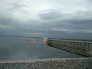
Singarayakonda is a town in Prakasam district of the Indian state of Andhra Pradesh. It is the mandal headquarters of Singarayakonda mandal. Singarayakonda is located at sea level. It is spread across 10 Grama panchayats. It is under Kandukur Revenue division. Singarayakonda is located 30 kilometers from Ongole. This is situated on the NH-5 Highway and has a connectivity of the Railway line between Vijayawada and Chennai. This gives highest revenue than any other station in this line of South Central Railway in the Prakasam district. This also has been the center for transportation for all the nearby villages which are located around a distance of the 15 kilometres (9.3 mi) from this place.

Pakala is a town in Tirupati district of the Indian state of Andhra Pradesh. It is the mandal headquarters of Pakala mandal. It comes under Tirupati revenue division.
Vinjamur is an upcoming town in Nellore district of the Indian state of Andhra Pradesh. It is the mandal headquarters of Vinjamur mandal.

Kanigiri is a town in Prakasam district of the Indian state of Andhra Pradesh. It is a municipality and the headquarters of Kanigiri mandal in Kanigiri revenue division.

Tangutur is a town in Prakasam district of the Indian state of Andhra Pradesh. It is a mandal headquarters in Ongole revenue division. Nearby towns are Singarayakonda, Kandukur, Prakasam district, Kondapi and the nearest city will be Ongole.
Seethanagaram is one of the 19 mandals in East Godavari district of the state of Andhra Pradesh, India. Its headquarters are located at Seethanagaram. The mandal is bounded by Devipatnam mandal, Korukonda mandal, Rajahmundry (rural) mandal and a part of it lies on the banks of Godavari River. It is sub urban growth of Rajamahendravaram City.
Palukuru is a village in the Kandukur mandal of the Prakasam district, from the state of Andhra Pradesh, India, located 33 kilometers south of district headquarters Ongole.
Chilakapadu is a village near Santhanuthala padu mandal, located in Prakasam district of the Indian state of Andhra Pradesh.
Kondapaturu is a village in Kakumanu Mandal in the Guntur District of Andhra Pradesh, India. It is located 35 km (22 mi) south of the main district of Guntur, 3 km (1.9 mi) from Kakumanu, and 296 km (184 mi) from Hyderabad, the state capital. Between March and April, Thirunalla is celebrated by 200,000 to 300,000 visiting worshippers every year.
Ongole mandal is one of the 56 mandals in Prakasam district of the state of Andhra Pradesh, India. It is administered under Ongole revenue division and its headquarters are located at Ongole. The mandal is bounded by Naguluppalapadu, Maddipadu, Santhanuthlapadu, and Kothapatnam Tangutur mandals. The mandals lies on the shore of Bay of Bengal.
Singarayakonda mandal is one of the 56 mandals in Prakasam district of the Indian state of Andhra Pradesh. Its headquarters are located at Singarayakonda. The mandal is bounded by Tangutur, Zarugumilli, Kandukur, and Ulavapadu mandals.
K. Rajupalem is a village in Prakasam district of Andhra Pradesh in India. It belongs to Ballikurava, Martur mandals and is inhabited by approximately 5371 people.
Mancherial district is a district located in the northern region of the Indian state of Telangana. The district comprises 18 mandals and two revenue divisions – Mancherial and Bellampalli. The district headquarters is located at Mancherial town. It is surrounded by Komaram Bheem, Nirmal, Jagtial, Peddapalli and Bhupalpally districts of Telangana and with Maharashtra state.
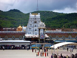
Tirupati district is one of the eight districts of Rayalaseema region in the Indian state of Andhra Pradesh. The district headquarters is located at Tirupati city. This district is known for its numerous historic temples, including the Hindu shrine of Tirumala Venkateswara Temple and Sri Kalahasteeswara temple. The district is also home to Satish Dhawan Space Centre, a rocket launch centre located in Sriharikota. The river Swarnamukhi flows through Tirupati, Srikalahasti, Naidupeta, Vakadu and join into the Bay of Bengal.

