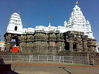
Paithan ['pəɪ.ʈʰaɳ], historically Pratiṣṭhāna [pɾə'tɪʂʈʰana], is a town with municipal council in Aurangabad district, Maharashtra, India. Paithan is located 56 kilometres (35 mi) south of present-day Aurangabad on the Godavari River. It was the capital of the Satavahana dynasty, which ruled from the second century BCE to the second century CE. It is one of the few inland towns mentioned in the famous first-century Greek book, the Periplus of the Erythraean Sea.
Mehkar is a tabletop tehsil and a municipal council situated in Buldhana district of the Indian state of Maharashtra. Located at the bank of Painganga River, Mehkar falls in the Vidarbha region of Maharashtra.

Parbhani district is one of the eight districts in the Marathawada region of Maharashtra state of India. Parbhani city is the headquarters of this district. Parbhani district is well known for religious tourism of Jainism, Hinduism.

Hingoli district is an administrative district in the state of Maharashtra in India. The district is headquartered at Hingoli. The district occupies an area of 4,526 km2 and has a population of 11,77,345 of which 15.60% were urban. Hingoli was actually known as the Nizams military base as it was bordered with Vidharbha. In that era military troops, hospitals, veterinary hospital were in operation from Hingoli. Being a military base the city was one of the important and famous places of the Hyderabad state. One of the twelve Jyotirlinga shrines, the Aundha Nagnath is located in Hingoli district about 25 km south-west from district headquarter.
Murtizapur is a Municipal council and one of the taluka of district of Akola of Amravati division of Vidarbha region of Maharashtra.
Akkalkot is a City and a municipal council in Solapur district in the Indian state of Maharashtra. It is situated 40 km southeast of Solapur and very close to the border between Maharashtra and Karnataka states.

Chiplun is a city in Ratnagiri district in the state of Maharashtra, India. It is the financial and commercial Hub of Ratnagiri, and the headquarters of Chiplun taluka. It is about 320 km south of Mumbai in the Konkan region of Maharashtra, on the Mumbai–Goa highway (NH-66). It has a long history and a strong cultural background. Recent decades have seen much industrial development in it and its and surrounding areas.

Gangakhed is a city located on banks of Godavari River and a municipal council in Parbhani district in the state of Maharashtra, India. It is also known as Dakshin Kashi. It is also the second largest city In Parbhani District.
Jintur city and a municipal council in Parbhani district in the Indian state of Maharashtra.
Loha is a town with municipal council in Nanded district in the Indian state of Maharashtra. Malegaon Yatra, is held every year in honour of Lord Khandoba in Malegoan, a village situated in Loha Taluka that is located 35 km from Nanded. Being on national highway 361 and 361F this is very well connected for the transportation for Mumbai,Goa-Raypur and Hyderabad.
Selu also known as Sailu is a city and a municipal council in Parbhani district in the Indian state of Maharashtra.
Tiosa, or Tivsa, is a town, municipal council, and tehsil in Amravati district in the state of Maharashtra, India.
Patole is a village in Sinnar taluka of Nashik district in the Indian state of Maharashtra. The current sarpanch of Patole is Shri Meghraj Suresh Avhad who is a civil engineer.
Mahagaon is a town in Gadhinglaj Taluka, Kolhapur district, situated in the southwest corner of the state of Maharashtra, India, on the banks of the Hiranyakeshi river. It is about 10 kilometres (6.2 mi) south of Gadhinglaj and 14 kilometres (8.7 mi) from the city of Kadgaon. It is managed by a town council. In 2011, it had a population of about 20,108.

Loni Kalbhor is a village 11 kilometres east of the City of Pune, Maharashtra, India.
Palam is a town and a headquarter of Palam taluka. It's located in Parbhani district which is part of State of Maharashtra in India.
Ranisawargaon also Rani Sawargaon, is a major village in Gangakhed taluka of Parbhani district in Indian state of Maharashtra.
Sayala is a village located in Palam Taluka of Parbhani district, in state of Maharashtra.
Golegaon (Palam) is a small village in Purna taluka of Parbhani district in the Marathwada region of Maharashtra, India with total 163 families residing. The Golegaon Palam village has population of 835 of which 454 are males while 381 are females as per Population Census 2011.

Jaipur is a village located in Motala Taluka of Buldhana district.


